Spent the weekend on the Withlacoochee State Trail, a paved bicycle trail that the Florida Trail shares for about 30 miles.
It's an old rail trail, so fairly straight, and gently graded up and down through this hilly area. I forgot the camera, so no pictures. Did see two turkeys, one peahen, one deer, and one silver fox, plus lots of squirrels. The trail was very busy with bicycles on Saturday morning and I spent a nice rest break at a pagoda in Floral city talking to some ex-Brits from a local cycling club. As the day started warming up though, the cyclists diminished and only us crazies were out!
Spent the night at Fort Cooper SP primitive camping area, which I shared with a Frat party. They were a little noisy late into the night, but other than that it was a good night.
The trail parrallels US41 for a lot of it's length, and there are plenty of businesses to stop by in for sodas, icecream, snacks etc., so I'm sure I didn't lose much weight this weekend!
I was hoping to make it all the way to the end of the bike trail at Gulf Jct on Sunday, but as the day started to heat up I changed plans and wimped out at Holder. I've been spending too much hiking time this summer hanging out where there is cool water, kayaking etc., and don't have the stamina for this hot blacktop stuff. Roll on cool weather!
View more photos in my Picasa album
Sunday, September 24, 2006
Saturday, August 19, 2006
Orlando Wetlands Park
Nice trail round the water impoundment ponds. Saw lots of birds and a couple of gators, then ran for our lives back to the car when we saw a very large thunderstorm coming at us.
View photos in my Picasa album
View photos in my Picasa album
Saturday, June 3, 2006
Northern Arizona trip
North Rim
My intended destination was Point Imperial, but that plan was cut short when the Park Service closed the road due to very high winds and falling trees. I spent some time at the North Rim viewpoints (carefully hanging on) instead. As my trip to Point Imperial had been cut short I had some time to wander around at Lee's Ferry where I was camped.
The timing of this trip is to attend a Grand Canyon Field Institute Photography workshop. The first hike was into Cathedral Wash for the afternoon where we all took some basic pictures to be critiqued later that evening. Stupid me fell on a rock during this hike, severely curtailing my activities for the remainder of the week. By the time we returned to the Marble Canyon Lodge my foot was bruised, swollen, and extremely painful. I stopped at the gas station to buy ice, then attempted to sleep that night in the car with my foot in a cooler. Yeah, that was comfortable!
The next day's hike was into Buckskin Gulch. I wasn't even sure if I could make it, but I had wanted to do this hike for so long that I just had to try. I used my tripod more as a crutch than a base for the camera, and I didn't get near as far down the canyon as everyone else, but I did get some decent pictures, and learned a lot about lighting techniques, which would be very useful later in the trip.

The next day I was a lot more mobile again, enough so that I led the charge up our next destination, Yellow Mountain. This location was a lot of fun for me: we were out int he sunshine, in terrain that was totally new to me and unique. I loved it. I have to add this to my bucket list of places to hike more and explore. It's an area of eroded cross bedded sandstones with limestone fins that were originally casued by higher rock layers leached down through the sandstone and depositing limestone in the cracks between sandstone blocks. As the sandstone has eroded the harder limestone erodes more slowly and leaves angular fins protruding. The fins are very fragile, requiring careful footing to prevent breakage, but they make for some interesting photographs. The mainly areas light colored rock in this area is very stained by mineral desposits leaching through the existing rock, or from layers that have since eroded away, leaving interesting patches of reds and yellows.
The news about the last day of the photo class was very disappointing to me. I was hoping to visit one of the Coyote Buttes sites, or another dramatic area such as yesterday. When I found out the plan was to visit a stream loction to photograph trees I decided to abandon the remainder of the seminar and go my own way for the next couple of days. It was too late to get my own permit for Coyote Buttes so I decided to visit a couple of nearby areas that I'd wanted to visit.
 Lower Antelope Canyon is a very narrow sinuous slot canyon of sandstone. The Navajo guide led us into the slot by sitting on the edge of a crack int he sandstone and stepping down into the narrow entrance. The canyon is very quite narrow in places and has some fairly steep natural drops which have metal steps to assist getting down into the depths of the canyon. The entire 1/2 mile length is a wonderful twisted experience of wind and water eroded sandstone. Most of the sandstone is smoothly weathered, but the are occasional stone embedded layers that add texture in the wall patterns. The footing is sometime a level sandy layer, but occasionally the slot walls slope all the way down to the floor, requiring careful footing. The Lower Canyon does not seem as popular as the Upper Canyon, but is uniquely different, quieter, and definitely worth a visit at any time of day. In 1997, eleven tourists were drowned during a flash flood in Lower Antelope Canyon. Obviously, the canyon is now closed during any chance of rain or flood.
 Upper Antelope Canyon is wider at the bottom than the lower canyon, but the very narrow top allows light to shine directly into the canyon only in a few small places, and only when the sun is directly overhead during the middle of the day. This causes shafts or beams of intense light in the very dark canyon. Breezes from above cause sand and dust to filter down through the cracks enhancing the shafts. The canyon is beautiful, has a much more level and wider floor than Lower Antelope canyon, and is very different. It is extremely busy in the canyon during the 2 hours of most intense lighting, and very difficult to get unobstructed photographs, but a beautiful place, and definitely worth a visit.
 Next, I knew there was a place somewhere on the Colorado Rim somewhere in the 15 miles between Glen Canyon Dam and Lees Ferry where there was an overlook of Horseshoe Bend, so I set out to find it, starting at Glen Canyon Dam and working my way downriver. I eventually found a trailhead with a couple of miles hike to the overlook, again well worth it.
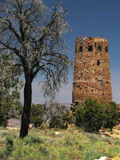 Next day I visited Walnut Canyon to see the Sinagua Cliff Dwellings. I did not find these neraly as dramatic as the ruins at Sierra Ancha I had seen last year. I also visited the South Rim of the Grand Canyon, but decided to forego the South Rim village as I'd already been there, and stopped at Desert View WatchTower instead. I enjoyed the river views available here that you don't get at the Village, and particuarly being able to look down on the wide beach at Furnace Flats where I'd slept on a rafting trip.
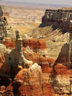 Last stop was at Coal Mine Canyon. It is like a miniature Bryce Canyon. I would have loved to hike down into the canyon, but the canyon is remote, and there were no other vehicles around at the parking area so it seemed prudent not to venture down alone. I satisfied myself with pictures from the rim.
View more photos in my Picasa album
My intended destination was Point Imperial, but that plan was cut short when the Park Service closed the road due to very high winds and falling trees. I spent some time at the North Rim viewpoints (carefully hanging on) instead. As my trip to Point Imperial had been cut short I had some time to wander around at Lee's Ferry where I was camped.
The timing of this trip is to attend a Grand Canyon Field Institute Photography workshop. The first hike was into Cathedral Wash for the afternoon where we all took some basic pictures to be critiqued later that evening. Stupid me fell on a rock during this hike, severely curtailing my activities for the remainder of the week. By the time we returned to the Marble Canyon Lodge my foot was bruised, swollen, and extremely painful. I stopped at the gas station to buy ice, then attempted to sleep that night in the car with my foot in a cooler. Yeah, that was comfortable!
The next day's hike was into Buckskin Gulch. I wasn't even sure if I could make it, but I had wanted to do this hike for so long that I just had to try. I used my tripod more as a crutch than a base for the camera, and I didn't get near as far down the canyon as everyone else, but I did get some decent pictures, and learned a lot about lighting techniques, which would be very useful later in the trip.

The next day I was a lot more mobile again, enough so that I led the charge up our next destination, Yellow Mountain. This location was a lot of fun for me: we were out int he sunshine, in terrain that was totally new to me and unique. I loved it. I have to add this to my bucket list of places to hike more and explore. It's an area of eroded cross bedded sandstones with limestone fins that were originally casued by higher rock layers leached down through the sandstone and depositing limestone in the cracks between sandstone blocks. As the sandstone has eroded the harder limestone erodes more slowly and leaves angular fins protruding. The fins are very fragile, requiring careful footing to prevent breakage, but they make for some interesting photographs. The mainly areas light colored rock in this area is very stained by mineral desposits leaching through the existing rock, or from layers that have since eroded away, leaving interesting patches of reds and yellows.
The news about the last day of the photo class was very disappointing to me. I was hoping to visit one of the Coyote Buttes sites, or another dramatic area such as yesterday. When I found out the plan was to visit a stream loction to photograph trees I decided to abandon the remainder of the seminar and go my own way for the next couple of days. It was too late to get my own permit for Coyote Buttes so I decided to visit a couple of nearby areas that I'd wanted to visit.
 Lower Antelope Canyon is a very narrow sinuous slot canyon of sandstone. The Navajo guide led us into the slot by sitting on the edge of a crack int he sandstone and stepping down into the narrow entrance. The canyon is very quite narrow in places and has some fairly steep natural drops which have metal steps to assist getting down into the depths of the canyon. The entire 1/2 mile length is a wonderful twisted experience of wind and water eroded sandstone. Most of the sandstone is smoothly weathered, but the are occasional stone embedded layers that add texture in the wall patterns. The footing is sometime a level sandy layer, but occasionally the slot walls slope all the way down to the floor, requiring careful footing. The Lower Canyon does not seem as popular as the Upper Canyon, but is uniquely different, quieter, and definitely worth a visit at any time of day. In 1997, eleven tourists were drowned during a flash flood in Lower Antelope Canyon. Obviously, the canyon is now closed during any chance of rain or flood.
  Upper Antelope Canyon is wider at the bottom than the lower canyon, but the very narrow top allows light to shine directly into the canyon only in a few small places, and only when the sun is directly overhead during the middle of the day. This causes shafts or beams of intense light in the very dark canyon. Breezes from above cause sand and dust to filter down through the cracks enhancing the shafts. The canyon is beautiful, has a much more level and wider floor than Lower Antelope canyon, and is very different. It is extremely busy in the canyon during the 2 hours of most intense lighting, and very difficult to get unobstructed photographs, but a beautiful place, and definitely worth a visit.
  Next, I knew there was a place somewhere on the Colorado Rim somewhere in the 15 miles between Glen Canyon Dam and Lees Ferry where there was an overlook of Horseshoe Bend, so I set out to find it, starting at Glen Canyon Dam and working my way downriver. I eventually found a trailhead with a couple of miles hike to the overlook, again well worth it.
 Next day I visited Walnut Canyon to see the Sinagua Cliff Dwellings. I did not find these neraly as dramatic as the ruins at Sierra Ancha I had seen last year. I also visited the South Rim of the Grand Canyon, but decided to forego the South Rim village as I'd already been there, and stopped at Desert View WatchTower instead. I enjoyed the river views available here that you don't get at the Village, and particuarly being able to look down on the wide beach at Furnace Flats where I'd slept on a rafting trip.
 Last stop was at Coal Mine Canyon. It is like a miniature Bryce Canyon. I would have loved to hike down into the canyon, but the canyon is remote, and there were no other vehicles around at the parking area so it seemed prudent not to venture down alone. I satisfied myself with pictures from the rim.
View more photos in my Picasa album
Sunday, May 7, 2006
Rodman Dam
It was a hot, humid, sticky night, and the attempts to get into the breeze didn't work! We were up fairly early in the morning, it had been a fairly restless night anyway, due to the heat, and once again we knew that the southbound hiking group would be out much earlier than we could possibly manage. They stay at civilized campgrounds, and don't have to pack up camp and load up backpacks before starting out in the morning. And they get up much earlier! We will get a chance to experience their style of hiking tomorrow as we will be shuttling up to their campground today after our hike, camping with them ,and shuttling back to todays end point to hike with them tomorrow. Today is Jack Hailman's 70th birthday and he is having a birthday dinner celebration which we don't want to miss out on. Deb Blick of the Florida Trail Association is GPS'ing a section of the trail from Lake Delancy campground this morning, and has agreed to wait for us at the trail crossing and will shuttle us to Rodman campground where the main group of day hikers will be camped.
Once again, I met up with the lead hikers very shortly after getting started out. I didn't stop for long, as I knew I'd be seeing them and have an opportunity to socialize tonight. At Grassy Pond, I took the blue blaze into the now abandoned campsite for a look around. When I returned to the trail I had no idea if Ian was now still behind me, or up in front. The morning air was already very humid, and even the early sunshine beginning to feel hot. The trail here is a “tunnel” between scrub and brush walls about 12’ high on both sides through pine forest. Visibility is mostly limited to straight ahead, and restricted by twists and turns of the trail. I was looking for a fallen tree in the shade for a suitable place for a quick water break, when I disturbed an animal that was very close, or possibly even on the trail. There was a bend in the trail at that point, and it was very shaded, but the noise receding off to the east was of a large animal, very unlike the bounding sound of a startled deer, more of a crashing, thunderous stomp. My obvious thought was “Bear”. I stopped, peered into the dense understorey, hoping to at least glimpse the famous “bear butt disappearing into the woods”, but saw nothing, no sign at all. Whatever it was had clearly retreated quite far off, but I decided to continue on a little way before I took my break. Just in case. After a fairly brisk quarter mile I decided I had put enough distance between me and my “probably a bear” to take a break, and came around a large bush to a widening of the trail where an old and apparently non-maintained trail crossed. There was no log to sit on, but the less dense cross trail allowed a little more of the cooling breeze to flow down to ground level. Removing my pack, I perched on the pack on the west side of the crossing. Ten minutes or so later, I reached around me to re-secure to the water bottle. While looking down, I heard movement coming up the trail behind the large bush. I couldn’t see round the bush, but made the natural assumption it was Ian. Surprise! Bear! Head on, on all fours, and about 3 feet tall at the withers, with a blue collar and radio transmitter. He saw me at the same time I saw him. It was a split second encounter. We were both as surprised as the other. He crashed off again to the east, I picked up and hastily shouldered the pack.
I remember thinking several things at once: “Bear!”, “That’s not Ian - Run”, “Where’s my camera?”, “Forget the water bottle – Run”, “Wish I’d had my camera ready for that”, “Run”, “Wow, I should warn Ian there’s bear”. I hastily scrawled the word “BEAR” in 12 inch high letters in the sand with my hiking pole, and set off up the trail at a fast pace. In my hurry, with my pack not properly balanced, and trying to look behind while making forward progress, I stumbled into the trailside brush, narrowly missed poking my eye out on protruding branch, and wrenching my right hamstring. After limping along a little further I came to a fallen tree at just the right height, angle, and position to take the weight of the pack while I readjusted it, and check out the minor damage, while still having a reasonable view back down the trail. I had just readjusted the backpack and was bending down to massage the back of my right thigh when I caught a glimpse of something black and moving on the shaded trail behind me. I ignored the 40lbs on my back, my straining hamstring, and my heart pounding. I ran. I think I ran for about half a mile before I reach the junction a road and ATV dirt trail, and the terrain changed from dense understoried pine to sparse/clear cut open pine. I collapsed on the grass by the road. With a clear view of open space around me, I grabbed my full 2 liter water bladder from the pack, almost drained it, then lay sprawled and cooling, heart gradually slowing, in the shade. Distance, and drop in adrenaline increases rationality. By now I was pretty sure the bear was probably just ambling along the trail minding his own business, as scared of me as I was of him. I may or may not have seen him reappear at the log, it could have just been a moving dense shadow. All I heard now were ATV motors in the distance, coming closer, headed in my direction. Ian caught up to me at my next break, around 10am as we had discussed. He had not seen any sign of the bear, but had seen my sign in the sand. As a classic example of how men think differently to women. I wrote “BEAR”, he read “BEER” and spent a few moments looking round the trail crossing for a cooler of cold ones! I’m just glad there wasn’t a hungry bear waiting in the brush for an unsuspecting, beer hunting hiker! As we approached Lake Delancy the trail enters an area of old clay pits, making it very reminiscent of the "trenches" in the beech woods near where I grew up. It was a little hilly, very pretty and would have been a pleasant place to hang out for while. Unfortunately, my wrenched hamstring was starting to bother me, as I changed my foot angle to bear my weight going downhill on the slippery oak leaf covered slope, I pulled the muscle again. At the same time, the revenge of last night's reheated prefrozen sandwich also made it's presence known. I was not a happer backpacker for a few minutes. Ian was ahead of me at this point, and must have been concerned that I hadn't caught up to him, as he kept calling down the trail to see if I was OK, but I finally caught up when he promised it was only another 1/4 mile. He lied! We saw an old blue blaze, but only a few steps down the unused trail made us think the trail marking was wrong. We turned back to the main trail and continued north. This area has ATV trails running everywhere. Thankfully, some of these have been blocked and are starting to recover from the "sandy pit" stage and start to look more like hiking trails. A little way down the trail was one of these recovering trails, and I could see the campground road at the end of it. Thinking that if the blue trail we saw was actually correct, we should go down to the road to look for Deb's truck, I set off down it. No sign of Deb or the truck, but there was a bend in the road, so I walked back east on the road for a while, but still no sign. We set off west again, Ian on the trail, and me paralleling him, hobbling along the dirt road. After a while Ian joined me down on the road. We walked west on the road a while, still no sign, so we turned round and walked east again, back the way I had come,and past where I had walked down to the road again. At the point where the road totally disintegrated into a sand pit I asked a passing ATv'er where the campground entrance was, and of course, it was back to the west, and he said it was "a long way". I'm sure I could have got a ride if I'd wanted too, but we trudged back west and picked up the trail again.
Finally, actually not too far down, but far enough for my leg, we came out to another dirt road, and found Deb and truck, and cold fresh water (thanks Deb), and cold diet Pepsi (thanks Deb), and cool shade to sit in.Deb drove us to Rodman Campground and we claimed our campsite and collapsed in the shade for afternoon siesta. Later, we set up our tents and had a shower to clean up. The birthday dinner was very enjoyable. I finally got to chat with some of the day hikers I had been crossing paths with and playing tag with over the past couple of sections The food was good, and the company pleasant. We discussed my full frontal bear sighting, and that's when I founf out that others had seen or heard him earlier as they had passed through too. I wish I'd known that, I might not have run so fast if I'd known he was just hanging out and wasn't some starved rogue bear looking for a tasty hiker morsel!
After dinner, back to the campsite, the bugs weren't too bad, and it did not seem as sticky as the previous night. We headed into the tents for an early night. I was right, the day hikers DO get up early. They are starting out for the trail at 5:30am! That means a 4:30am start for those of us that want to get tents repacked before hiking.Well we did it, we woke up at 4:30, packed everything we didn't need in my car, and snacks, water cameras, etc, in the now very light backpacks, jumped in the car and followed Jack back to the Lake Delancy trail crossing.
We started out hiking at 6am, and boy do those folkls hike fast, and without stopping. Personally I'm a stop for a water break every hour, and stop if you see something nice, unusual, etc., hiker. I knew we needed to make fairly quick time this morning, as I needed Jack and Liz's assistance to get me back to my car at the end of the hike, but I was determined to enjoy the hike too. At my first stop the majority of the pack of hikers passed me. I leapfrogged a couple of them again when I started back up again, but by my second stop I had caught up to Ian, and we both had been passed by everyone else. We have our own slow and steady, "enjoy the scenery" pace.
 I set off again leaving Ian to follow. He finally caught up to me just before we reached the lake at Rodman Dam, and together we caught up to the last day hiker who was just leaving the lake after a break as we arrived. And what a place for a break. The shallow clear lake is edged by a sandy beach covered in huge drfitwood logs. I couldn't resist going in for a swim, then relaxing a while on a log. Once we get up on the dam there will be no shade. We rested and cooled off for a while before tackling the dam road, across the dam, and then the last little shady forest stretch into the campground.
 After cooling off, realxing a while and showering, we were about to set off in Jack and Liz's van when we realized it had a flat tire. Not a big deal with five of us acting co-operatively. After the slight delay, a bit of dust and a little bit of effort we were on our way back to civilization.
I've said it several times on the last couple of hot weekend sections. It's too hot for backpacking! Seeing how the remainder of the group base camped and day hiked made a lot of sense to me after spending the past several weekend sections dragging my fully loaded pack and water around in the heat. Day hiking is definitely the way to go for the remainder of the summer!
Having got to know Ian better, he seems like a really nice guy. I'm glad I took the chance to backpack with him, on Charles and Mary's recommendation. He is also planning to hike the entire FL Trail as time allows. He is retired from the military and does not work, so has much more time available to hike than I do, but hopefully I will be able to catch up to him for some weekend hikes occasionally.
View more photos in my Picasa album
Once again, I met up with the lead hikers very shortly after getting started out. I didn't stop for long, as I knew I'd be seeing them and have an opportunity to socialize tonight. At Grassy Pond, I took the blue blaze into the now abandoned campsite for a look around. When I returned to the trail I had no idea if Ian was now still behind me, or up in front. The morning air was already very humid, and even the early sunshine beginning to feel hot. The trail here is a “tunnel” between scrub and brush walls about 12’ high on both sides through pine forest. Visibility is mostly limited to straight ahead, and restricted by twists and turns of the trail. I was looking for a fallen tree in the shade for a suitable place for a quick water break, when I disturbed an animal that was very close, or possibly even on the trail. There was a bend in the trail at that point, and it was very shaded, but the noise receding off to the east was of a large animal, very unlike the bounding sound of a startled deer, more of a crashing, thunderous stomp. My obvious thought was “Bear”. I stopped, peered into the dense understorey, hoping to at least glimpse the famous “bear butt disappearing into the woods”, but saw nothing, no sign at all. Whatever it was had clearly retreated quite far off, but I decided to continue on a little way before I took my break. Just in case. After a fairly brisk quarter mile I decided I had put enough distance between me and my “probably a bear” to take a break, and came around a large bush to a widening of the trail where an old and apparently non-maintained trail crossed. There was no log to sit on, but the less dense cross trail allowed a little more of the cooling breeze to flow down to ground level. Removing my pack, I perched on the pack on the west side of the crossing. Ten minutes or so later, I reached around me to re-secure to the water bottle. While looking down, I heard movement coming up the trail behind the large bush. I couldn’t see round the bush, but made the natural assumption it was Ian. Surprise! Bear! Head on, on all fours, and about 3 feet tall at the withers, with a blue collar and radio transmitter. He saw me at the same time I saw him. It was a split second encounter. We were both as surprised as the other. He crashed off again to the east, I picked up and hastily shouldered the pack.
I remember thinking several things at once: “Bear!”, “That’s not Ian - Run”, “Where’s my camera?”, “Forget the water bottle – Run”, “Wish I’d had my camera ready for that”, “Run”, “Wow, I should warn Ian there’s bear”. I hastily scrawled the word “BEAR” in 12 inch high letters in the sand with my hiking pole, and set off up the trail at a fast pace. In my hurry, with my pack not properly balanced, and trying to look behind while making forward progress, I stumbled into the trailside brush, narrowly missed poking my eye out on protruding branch, and wrenching my right hamstring. After limping along a little further I came to a fallen tree at just the right height, angle, and position to take the weight of the pack while I readjusted it, and check out the minor damage, while still having a reasonable view back down the trail. I had just readjusted the backpack and was bending down to massage the back of my right thigh when I caught a glimpse of something black and moving on the shaded trail behind me. I ignored the 40lbs on my back, my straining hamstring, and my heart pounding. I ran. I think I ran for about half a mile before I reach the junction a road and ATV dirt trail, and the terrain changed from dense understoried pine to sparse/clear cut open pine. I collapsed on the grass by the road. With a clear view of open space around me, I grabbed my full 2 liter water bladder from the pack, almost drained it, then lay sprawled and cooling, heart gradually slowing, in the shade. Distance, and drop in adrenaline increases rationality. By now I was pretty sure the bear was probably just ambling along the trail minding his own business, as scared of me as I was of him. I may or may not have seen him reappear at the log, it could have just been a moving dense shadow. All I heard now were ATV motors in the distance, coming closer, headed in my direction. Ian caught up to me at my next break, around 10am as we had discussed. He had not seen any sign of the bear, but had seen my sign in the sand. As a classic example of how men think differently to women. I wrote “BEAR”, he read “BEER” and spent a few moments looking round the trail crossing for a cooler of cold ones! I’m just glad there wasn’t a hungry bear waiting in the brush for an unsuspecting, beer hunting hiker! As we approached Lake Delancy the trail enters an area of old clay pits, making it very reminiscent of the "trenches" in the beech woods near where I grew up. It was a little hilly, very pretty and would have been a pleasant place to hang out for while. Unfortunately, my wrenched hamstring was starting to bother me, as I changed my foot angle to bear my weight going downhill on the slippery oak leaf covered slope, I pulled the muscle again. At the same time, the revenge of last night's reheated prefrozen sandwich also made it's presence known. I was not a happer backpacker for a few minutes. Ian was ahead of me at this point, and must have been concerned that I hadn't caught up to him, as he kept calling down the trail to see if I was OK, but I finally caught up when he promised it was only another 1/4 mile. He lied! We saw an old blue blaze, but only a few steps down the unused trail made us think the trail marking was wrong. We turned back to the main trail and continued north. This area has ATV trails running everywhere. Thankfully, some of these have been blocked and are starting to recover from the "sandy pit" stage and start to look more like hiking trails. A little way down the trail was one of these recovering trails, and I could see the campground road at the end of it. Thinking that if the blue trail we saw was actually correct, we should go down to the road to look for Deb's truck, I set off down it. No sign of Deb or the truck, but there was a bend in the road, so I walked back east on the road for a while, but still no sign. We set off west again, Ian on the trail, and me paralleling him, hobbling along the dirt road. After a while Ian joined me down on the road. We walked west on the road a while, still no sign, so we turned round and walked east again, back the way I had come,and past where I had walked down to the road again. At the point where the road totally disintegrated into a sand pit I asked a passing ATv'er where the campground entrance was, and of course, it was back to the west, and he said it was "a long way". I'm sure I could have got a ride if I'd wanted too, but we trudged back west and picked up the trail again.
Finally, actually not too far down, but far enough for my leg, we came out to another dirt road, and found Deb and truck, and cold fresh water (thanks Deb), and cold diet Pepsi (thanks Deb), and cool shade to sit in.Deb drove us to Rodman Campground and we claimed our campsite and collapsed in the shade for afternoon siesta. Later, we set up our tents and had a shower to clean up. The birthday dinner was very enjoyable. I finally got to chat with some of the day hikers I had been crossing paths with and playing tag with over the past couple of sections The food was good, and the company pleasant. We discussed my full frontal bear sighting, and that's when I founf out that others had seen or heard him earlier as they had passed through too. I wish I'd known that, I might not have run so fast if I'd known he was just hanging out and wasn't some starved rogue bear looking for a tasty hiker morsel!
After dinner, back to the campsite, the bugs weren't too bad, and it did not seem as sticky as the previous night. We headed into the tents for an early night. I was right, the day hikers DO get up early. They are starting out for the trail at 5:30am! That means a 4:30am start for those of us that want to get tents repacked before hiking.Well we did it, we woke up at 4:30, packed everything we didn't need in my car, and snacks, water cameras, etc, in the now very light backpacks, jumped in the car and followed Jack back to the Lake Delancy trail crossing.
We started out hiking at 6am, and boy do those folkls hike fast, and without stopping. Personally I'm a stop for a water break every hour, and stop if you see something nice, unusual, etc., hiker. I knew we needed to make fairly quick time this morning, as I needed Jack and Liz's assistance to get me back to my car at the end of the hike, but I was determined to enjoy the hike too. At my first stop the majority of the pack of hikers passed me. I leapfrogged a couple of them again when I started back up again, but by my second stop I had caught up to Ian, and we both had been passed by everyone else. We have our own slow and steady, "enjoy the scenery" pace.
 I set off again leaving Ian to follow. He finally caught up to me just before we reached the lake at Rodman Dam, and together we caught up to the last day hiker who was just leaving the lake after a break as we arrived. And what a place for a break. The shallow clear lake is edged by a sandy beach covered in huge drfitwood logs. I couldn't resist going in for a swim, then relaxing a while on a log. Once we get up on the dam there will be no shade. We rested and cooled off for a while before tackling the dam road, across the dam, and then the last little shady forest stretch into the campground.
  After cooling off, realxing a while and showering, we were about to set off in Jack and Liz's van when we realized it had a flat tire. Not a big deal with five of us acting co-operatively. After the slight delay, a bit of dust and a little bit of effort we were on our way back to civilization.
 I've said it several times on the last couple of hot weekend sections. It's too hot for backpacking! Seeing how the remainder of the group base camped and day hiked made a lot of sense to me after spending the past several weekend sections dragging my fully loaded pack and water around in the heat. Day hiking is definitely the way to go for the remainder of the summer!
Having got to know Ian better, he seems like a really nice guy. I'm glad I took the chance to backpack with him, on Charles and Mary's recommendation. He is also planning to hike the entire FL Trail as time allows. He is retired from the military and does not work, so has much more time available to hike than I do, but hopefully I will be able to catch up to him for some weekend hikes occasionally.
View more photos in my Picasa album
Friday, May 5, 2006
Store 88
 At the Florida Trail conference a couple of weeks ago I met several really nice people who indicated a desire to hike the FL Trail. One of these was a guy named Ian, who knows my friends Charles and Mary well. Since then he heard of a group intending to hike the length of the Ocala National Forest. They will be doing day hikes, but Ian had decided to backpack the same distance, and roughly matching his daily hiking to the same sections as theirs so he will at least bump into them, or hike a short while with them each day.
 I could not get the entire week off due to an out of town business trip, but joined in at Juniper Springs, preferring to backpack it with Ian than join the day hikers. We set off northbound from Juniper Springs campground around 6pm for the short hike into Hidden Pond where we intended to spend the night.
The trail passes through the Juniper Wilderness area, where no vehicles, bicycles, etc are allowed, and no motorized equipment is used to maintain the trail. As a result, the trail is a little rougher than most of the FL trail system, with grasses, brush, and several blown down trees, encroaching on the trail. It was a pleasant hike though, especially once the heat disappeared from the sun. We spotted a coral snake on the trail, which I mistook for a scarlett kingsnake, at least until I got home and saw the photos of it. Lucky I didn't try to pick it up! After that, we arrived at Hidden the pond and campsite quite quickly, just as it was getting dark. We quickly got camp set up, etc. I returned to the pond to collect water and wash up for the night, apparently totally oblivious to the alligator who was hanging out with me while I did so, but the next person down to the pond saw only two big red eyes staring out from a few feet out in the water. I guess I need to wear my glasses when I'm bathing!
We sat around for several hours talking, and getting eaten alive by mosquitos, then retired for the night. The night was fairly cool, but I'm told byt those that had been out camping the previous night that it was a big improvement. Next morning was cool and misty, but that just made Hidden Pond prettier as the sun rose.
 We were fairly slow getting started off in the morning. The fastest of the southbound group of hikers, hiking back to Juniper Springs campground, approached us as we filled up our water for the day. I set off again northbound as he left, and over the next 10 - 15 mins met up with the remainder of the southbound group. They had set off from the Hopkins Prairie campground crossing, and must get up early and hustle first thing in the morning!
 The hiking was pleasant while the trail was shaded, and there were many small ponds to rest by. Late morning I scared up something very large in the scrub off to the east of the trail, but could not tell what it was. After the trail left the wilderness area was an area of a mile or so that was apparently very damaged by 2004's hurricanes, and was subsequently clear cut/recovered to remove the blown down trees. It was approaching noon, the sun hot, and only a very light breeze. Fortunately, we arrived at FR86 and the Hopkins Prairie campground sinkhole. We had already decided that if the day turned out to be too hot for hiking, that we would find somewhere shady and pleasant to siesta in the heat of the day. The sinkhole was perfect. Cool water and light shade. We headed down the steps to the sinkhole. I swam a while to cool off, then we ate lunch, and napped for a while. A water snake was hanging around where I had accessed the water, but I didn't get a photo of it. Eventually, the shade moved, and our little piece of paradise became hot and sunny, so we filled up on water again, and moved back into the forest and denser shade for the remainder of the afternoon.
As the shadows moved around during the remainder of the afternoon, we kept moving our gear and our napping selves around to stay in the shade. At one stage, afetr moving to a new shady spot, we noticed a wasp buziing around us, but clearly not interested in us as much as in my pack, and the sandy ground around it. We watched it curiously for a while as it dug around on the ground shoving leaves and tree debris pieces around, obviously looking for something. Shortly afterwards, when we moved again to set up and cook dinner, I found the reason why the wasp had been so interested in my pack. I had put the cak down on the wasp's hole, and it obviously knew it was there, but just could not figure out what had happened to it.
After dinner, hoping that the heat would dissipate quickly in the breeze that had picked, we set off hiking again into Hopkins Prairie. The trail around the Prairie had been closed until very recently due to high water from the hurricanes of the past couple of years. Due to the lack of maintenance the grasses were very overgrown, over head height for the most part, and there were a couple of areas where trail markers had blown away etc. The trail was a little had to follow in places, but as the water was rarely more than 20 - 30 feet from the trees there was usually a good indication of where the trail should go. Any inconvenience on the trail was more than compensated by the beauty of the prairie. The setting sun and the wonderful cooling breeze, with no-one else around made this an idyllic hiking evening.
Around the middle of the prairie I lost the trail blazes and doubled back to the last blaze a couple of times to look for the next one. After several times around and across a clearing, I just could not spot the trail. One possible direction would take me through sludgy sticky looking mud, and another through the edge of the lake, neither of which I was particularly keen to tackle with the light starting to fade. Other options would take me through thick overgrown brush, and just didn't look right. All the possible options would take me out of sight of this last obvious trail marker, and not knowing how far behind me Ian was, the last thing I wanted was for him to reach the same point and magically see the trail, while I was off blaze hunting out of sight. I doubled back a little, hoping to meet up with him and/or see a suitable place to camp for the night. When we did meet up, obviously he did not think the light was fading as fast as I, as we decided to return to where I had lost the trail, and attempt to pick it up again.
 As we skirted round the clearing again to look for the blaze, Ian happened to look down, and at his feet was a tiny fawn resting at the base of some tall grasses. We both pulled out our cameras and spent several minutes up close photographing it. It never moved except to flare it's nostrils a couple of times. We speculated that it's Momma had told it to stay put, and staying put it was. I'm just glad we weren't a couple of gators!
 Despite the distraction of the fawn, Ian managed to find the next trail blaze up close to the trees on the opposite side of the clearing (I had been looking too far out towards the water), and we continued on the trail. A short while later, we found a nice breezy, short grass spot among the tall grasses to set up camp for the night. A nearby recently sawed blown down tree provided convenient log seats that were easily rolled the short distance to camp. We had no access to water, but were carrying sufficient to last overnight and for our initail morning needs anyway. It was perfect, and the breeze held most of the mosquitos at bay too! Just before retinring for the night Ian saw the headlights of a car in the area of the clearing where we had seen the fawn. I couldn't see the lights, but did hear the sound of engine and wheels squealing as they driver attempted to release vehicle from the mud he was obviously stuck in! The noise continued for a while, and shortly after we had settled in our respective tents, we heard the sounds of cussing and shouting, as the vehicles occupants returned back on the road they had driven in on, this time on foot! Other than that disturbance, it was a great night for camping, warmer than the previous night, but with the pleasant breeze moderating the temperature. Next morning, the sunrise was as beautiful as the sunset the night before.
We had decided we needed an early start today as the remainder of the group would likely start out very early, and we wanted to hike with them for a while. After a quick breakfast and easy pack up we were on the trail. The trail turned muddy and wet very quickly after we started out. I am in two minds about whether I would have rather have covered the wet section late in the day last night, to give my boots an opportunity to dry out, but the spot we had camped in had been so pleasant that I am glad we stopped. It may also have been not too pleasant to hike through the wet in the dark. Though apparently, last night had not been quite as dark for Ian as it had for me. When I woke this morning and reached for my glasses, I found only my sunglasses. I was sure I had changed out of them when we stopped to photograph the fawn, but obviously had not. That explains why I thought it was getting too dark to hike, and also why I couldn't see the stuck car headlights. Ian had apparently just thought I was trying to be "cool" keeping them on after dark! Thanks hon!
In any case, if we had night hiked this section we might have missed the wild blueberry bushes in the dark and as we discovered this morning, we would have had to hike at least a couple more miles before we would reach another spot suitable for camping.
Not knowing what the water situation would be for the remainder of the day, we stopped at the first fairly easily accessible water and collected, filtered and treated enough for the remainder of the day. While we were stopped the first of the day hikers passed us, stopped for a while to talk, then continued ahead. The next passed us just as I was filled up, repacked and preparing to leave. Shortly after commencing hiking again I came to the wettest area of the trail, with water around mid calf deep. It mainly had a nice packed sandy bottom though, with only a few muddy spots where there were blown down trees, so wasn't too much hassle, just the inconvenience of wet feet.
I passed the second day hiker resting on a blow down before I left the prairie, and leapfrogged with him for a while as I came off the prairie and back into the forest. I also crossed paths with two unknown backpakers. We exchanged only "Hi's", so I'm not sure how long they had been hiking, or how long they were intending to hike, but they sure looked loaded up, yet extremely fresh and clean, so I'm sure they must have just set out. A little while later I arrived at CR314, and met up with the lead day hikers again. As we sat and rested in the shade the remainder of the group trickled in, talked a while and eventually everyone shuttled off.
We arrived at CR314 while the day was still too hot to hike in the sun. However, it wasn't particularly pleasant sitting on the side of the road with trucks racing past either, so we set off northbound into the forest for just a short distance before locating a suitable shady spot to wait until the heat died down a little. At around 6pm it hadn't cooled off much, but we started up for the evening anyway. There was quite a nice breeze blowing up in the tops of the trees, but unfortunately not much was making it down to trail level, except at the frequent dirt road crossings, which we took advantage of for cooling breaks. We were hoping to stop at Store 88, a convenience store and hiker institution where we hoped to stock up on fresh commercial water, as we were uncertain where we would find the next potable water source, and knew we had a long hot dry day ahead tomorrow. At 7pm, with a couple of miles still to cover, we stopped for a dirt road break, and while checking the hiker guide, were confused by the reference to the store as available 11am - 8pm. So we put a little rush on for the next couple of miles, then encountered a blue blaze paited on a tree. The connector trail to Store 88 is marked with blue blazes, but as we had not yet passed the convergence of the East and West Connector trails, we were a little confused. We finally decided that the blue blaze was old, and ignoring it, continued on. Shortly after that we did indeed come to the trail convergence, and very shortly after that, the correct blue blazed side trail.
So we arrived at Store 88, just a little before 8pm, very sweaty, and found that the reference in the book had been to the barbeque store, which we had known was closed anyway. Store 88 is a convenience store attached to a bar, and is open till 2am. So much for rushing!
Store 88 is great. The bartender came out and offered us cold beverages, that were much appreciated. There are picnic tables outside where we could dump and spread out our gear and collapse on to recover from past hour's humid, sticky, rush. We chatted a while with the occupants of another picnic table whose opening comment had been "Are you hiking?". They were very interested and pleasant though. After cooling off a little we decided to eat here instead of worrying about cooking at camp, unfortunately the bar had no food available except re-heated pre frozen sandwiches. We managed with a selection of those, desserts and candy, but there were repercussions from that the next day! When we had eaten dinner and filled up on water and snacks we set out back down the link trail to find somewhere to camp for the night. It was now dark and we had our headlamps on to see. If you've never hiked in the forest at night with a LED headlamp, you probably have no idea how many spiders there are in a forest. But with an LED headlamp, it's like walking into a Warner Brothers cartoon scene. You know, the one where there is a darkened room, and the only thing you see are pairs of white eyes staring back at you. We investigated the closest set of eyes, to find a big wolf spider sittong on the ground. Apparently the compound eyes of a spider glow like neon in reaction to LED light. The rest of the eyes we just tried ignore or avoid! Despite the spiders we decided we would rather camp close by here, than try to get up towards grassy pond. We had full water anyway, so did not need to worry about dry camping, and it was quite late by this time. The trail was under long leaf pines and open understorey here, which would make for a decent campsite, but could make following the trail in the dark a lot more difficult: all those spider eyes would be distracting and make finding the orange blazes harder! So we headed back up the trail and uphill for a while, hoping to get some advantage from the breeze by being up on the hill, set up camp and immediately straight into the tents to avoid the mosquitos.
View more photos in my Picasa album
Sunday, April 9, 2006
Green Swamp West - Lacoochee
The weather is getting hotter and more humid, and prime Florida backpacking time is drawing to an end. There is a missing piece of the Florida Trail through Green Swamp that I was determined to complete before it becomes too hot, so I decided to try to get it done this weekend. Looking at the maps, it appears that there may be a road access in the middle of the missing section, but after last weekends 8+ mile addition to a day hike when the "road" turned out to be locked, I decided to just throw on the backpack and hike through from 471 where Deb and I left off back in early March, to the first place I knew for sure I could get the car into at Lacoochee Clay Sink Road, camping overnight somewhere in the middle. This route would duplicate about 6 miles of last weekend's hike, but I could take more time over the pieces we had hurried, and take the loop hike along the river for the last part.
The day started off cloudy, but warm and humid. The early part of the trail is through open grasslands with sparse shade, so I was grateful for the hazy cloud cover. I startled a deer in the first couple of miles, actually it was a mutual startling, and he bounded away before I had the presence of mind to grab for the camera. Today was the first time while hiking in the Green Swamp and Richloam swamp areas that I have actually encountered other hikers on the trail. My first meeting was with a Boy Scouts of America group out for a five mile hike. We arrived together at a trail junction, and thinking these young men, unencumbered and only day hiking would be travelling at a faster pace than me weighted down with backpack and about 20 lbs of spare water I stopped for a brief drink break and let their group get ahead of me. That was a mistake, as I was soon on the heels of and practically falling over their slower members. Fairly soon I got the opportunity to put on a burst of speed to re-pass them. My next encounter was lone day-hiker who passed while I was taking my lunchbreak in a shady, breezy spot slightly off the trail.
As the day got hotter the sparse shade and high humidity was very draining, and I began to wish I was day hiking. The forest road portions of the trail were on sandy roads, and the lack of rain in this area for the past month or so made for some slow and dusty slogging through the sand.
Early afternoon the trail crossed Ranch Road. This was the road that I thought may have been accesible by car, but had decided not to risk as it was marked exactly the same way as last week's fiasco at Main Line Road. Of course, having not tried it the road was indeed accessible, and there were lots of cars on it! The really bad part was that it was HORRIBLY dusty, and I had to walk along it for about 1/4 of a mile. Every car that went past kicked up a big cloud of choking dust. Several of the more courteous drivers slowed down when they saw me, but it didn't lessen the dust much. I was very thankful when the trail headed back into the woods. The next hour or so was through a beautiful deeply shaded wood of massive mature oaks dripping with spanish moss. It was wonderful cool relief after the sparse shade and the dust. I scared up a very fast black snake that was lazing in the trial, but again the encounter was too brief for the camera.
 Mid afternoon I arrived at the Foster Bridge campsite, my home for the night. As soon as I arrived I collapsed on the bench and stretched out for a cool break. The mosquitos immediately homed in. There were enough of them out in broad daylight that I realized I was going to have to get my camp all set up and dinner, etc. completed before the sun went down so I could take refuge in the tent when the bugs really came out! I set up the tent, but it was warm enough and with little enough chance it would rain that I decided to forego the rain fly tonight so I could be out of the bugs, but hopefully get some breeze relief from the humidity too. Next chore was to go down to the river to refill my water bottles and take a cool dip if possible. As I set off for the river I immediately came to another recently burnt area. The wildfires have been quite bad recently due to all the dry weather we have been having. I had walked through so many burnt out patches today I had just not noticed the burnt smell here. As I continued I noticed that the fire here had been very recent. In fact, several areas were still smoldering. My tent was now set up less than 1/10th of a mile downwind on this smoldering burnt area, and it was extermely breezy. Knowing that, I used my hiking pole to rake through smoldering patches until they were no longer smoking. Around the next corner was a fallen burnt out tree, not just smoking, but actually burning with 3 small fires. I used an unburned log I found nearby to beat at the burning areas, and my hiking pole to rake through the dropped embers until the fire was out and nothing was smoking. Eventually I made it down to river to refill my water and wash up, which was even more needed now I was black and sooty! On the return to the campsite I checked all the previously smoking areas and the burnt out tree, but there was now no sign of smoke. I seriously considered repacking my tent and moving elsewhere to camp, but the next marked campsite was a further 6 miles up the trail, and I was not sure of the non site camping restrictions here. Knowing that it was turkey hunting season made me not too keen on remote camping, and seeing as the underbrush in this area was already all burnt out I decided to stay where I was. There are so many burnt out patches in this area anyway, and I hadn't noticed this one smoking until I was almost on top of it, so it is highly likely that anywhere else I chose to camp may also have the same danger anyway.
So I set up my own small fire in the fire ring to cook dinner, and enjoyed the early evening. My assumption had been correct, and as soon as the sun droppd the bugs began to increase, so I took refuge in the tent. The wind has also died down a lot, relieving my fire fears somewhat. Not having the rain fly on increased my visibility outside too, and as it got dark I took another careful look out into the darkness for signs of flames, but there were none. I pottered around in the tent for a while then tried to settle down for the night. It was hot and sticky, and the whining sound of mosquitos was all around the tent.
Of course, a night without the rain fly is a guaranteed drought breaker, and I was awoken by the first shower a little after midnight. I scrambled for the rain fly, jumped out of the tent to attach and stake it out. The most persistent of the mosquitos who had hung around waiting for me to leave the safety of my mesh cocoon were rewarded by my few unprotected minutes outside the tent, but I was fortunate not to let any back in there with me. The rain continued lightly for a while and I must have drifted back to sleep, but was awoken at 3am by an outright downpour accompanied by lightning and thunder. It was hot and humid in the tent, but I was dry and the rain was cooling the tent down rapidly. I got inside the sleeping bag for the first time and eventually managed a couple more hours of broken sleep.
The rain had stopped by the time I got up, but everything was soaked and very muddy and it was extremely humid. The areas around trhe campsite that had looked drab, dirty and dusty yesterday were now somewhat brightened by the overnight soaking. I am fascinated at the way the palmettos recover so quickly after ebing burned and this morning is no different. I had noticed the new green growth yesterday, but this morning it seems liker all the re-growing plants had sprouted the green beginnings of flowerheads. Maybe they had been there before and I just had not noticed. The contrast between burnt black, rust brown damage, and vibrant was beautiful. Anyway, I couldn't resist a few pictures.
 I soon reached and crossed Main Line Road, and was now hiking the same area we hiked last weekend. Today however, it is still early, and I have time to enjoy the views and take short breaks on the buffs above the Withlacoochee. On one such break I took off my shoes to dangle my feet in the river and find a tick that has embedded itself in my toe! Nice!
Another break was at a small rapid on the river. There was a Cypress growing against the bank with all its roots and knees exposed and hanging out over the river. I climbed out onto the exposed roots and sat 15 feet above the rapid watching the water flowing underneath me. A much nicer experience than the tick removal.
Despite the rain last night the swamp areas are still very dry, thought there seems to be much more grass than last week. It is above knee high in a lot of places, and I do not remember that from last week, though it seems like it couldn't have grown that high just since last night! There is one little stream crossing on this stretch, and surprisingly the water level actually seems lower this morning.
 My final stops for today are along the river loop trail. I'm not sure which river this is, it didn't seem to have enough flow to be the Withlacoochee, but more likely a feeder. The swamp area around the river was a vibrant mas off green grass carpeting around the Cypress trees. The river was serene and clear and seemed to have a good amount of flow. I could hear children's voices and expected to see a canoe appear at any time, but never saw the actual source of the noise, nor anyone for that matter.
View more photos in my Picasa album
The day started off cloudy, but warm and humid. The early part of the trail is through open grasslands with sparse shade, so I was grateful for the hazy cloud cover. I startled a deer in the first couple of miles, actually it was a mutual startling, and he bounded away before I had the presence of mind to grab for the camera. Today was the first time while hiking in the Green Swamp and Richloam swamp areas that I have actually encountered other hikers on the trail. My first meeting was with a Boy Scouts of America group out for a five mile hike. We arrived together at a trail junction, and thinking these young men, unencumbered and only day hiking would be travelling at a faster pace than me weighted down with backpack and about 20 lbs of spare water I stopped for a brief drink break and let their group get ahead of me. That was a mistake, as I was soon on the heels of and practically falling over their slower members. Fairly soon I got the opportunity to put on a burst of speed to re-pass them. My next encounter was lone day-hiker who passed while I was taking my lunchbreak in a shady, breezy spot slightly off the trail.
As the day got hotter the sparse shade and high humidity was very draining, and I began to wish I was day hiking. The forest road portions of the trail were on sandy roads, and the lack of rain in this area for the past month or so made for some slow and dusty slogging through the sand.
Early afternoon the trail crossed Ranch Road. This was the road that I thought may have been accesible by car, but had decided not to risk as it was marked exactly the same way as last week's fiasco at Main Line Road. Of course, having not tried it the road was indeed accessible, and there were lots of cars on it! The really bad part was that it was HORRIBLY dusty, and I had to walk along it for about 1/4 of a mile. Every car that went past kicked up a big cloud of choking dust. Several of the more courteous drivers slowed down when they saw me, but it didn't lessen the dust much. I was very thankful when the trail headed back into the woods. The next hour or so was through a beautiful deeply shaded wood of massive mature oaks dripping with spanish moss. It was wonderful cool relief after the sparse shade and the dust. I scared up a very fast black snake that was lazing in the trial, but again the encounter was too brief for the camera.
 Mid afternoon I arrived at the Foster Bridge campsite, my home for the night. As soon as I arrived I collapsed on the bench and stretched out for a cool break. The mosquitos immediately homed in. There were enough of them out in broad daylight that I realized I was going to have to get my camp all set up and dinner, etc. completed before the sun went down so I could take refuge in the tent when the bugs really came out! I set up the tent, but it was warm enough and with little enough chance it would rain that I decided to forego the rain fly tonight so I could be out of the bugs, but hopefully get some breeze relief from the humidity too. Next chore was to go down to the river to refill my water bottles and take a cool dip if possible. As I set off for the river I immediately came to another recently burnt area. The wildfires have been quite bad recently due to all the dry weather we have been having. I had walked through so many burnt out patches today I had just not noticed the burnt smell here. As I continued I noticed that the fire here had been very recent. In fact, several areas were still smoldering. My tent was now set up less than 1/10th of a mile downwind on this smoldering burnt area, and it was extermely breezy. Knowing that, I used my hiking pole to rake through smoldering patches until they were no longer smoking. Around the next corner was a fallen burnt out tree, not just smoking, but actually burning with 3 small fires. I used an unburned log I found nearby to beat at the burning areas, and my hiking pole to rake through the dropped embers until the fire was out and nothing was smoking. Eventually I made it down to river to refill my water and wash up, which was even more needed now I was black and sooty! On the return to the campsite I checked all the previously smoking areas and the burnt out tree, but there was now no sign of smoke. I seriously considered repacking my tent and moving elsewhere to camp, but the next marked campsite was a further 6 miles up the trail, and I was not sure of the non site camping restrictions here. Knowing that it was turkey hunting season made me not too keen on remote camping, and seeing as the underbrush in this area was already all burnt out I decided to stay where I was. There are so many burnt out patches in this area anyway, and I hadn't noticed this one smoking until I was almost on top of it, so it is highly likely that anywhere else I chose to camp may also have the same danger anyway.
 So I set up my own small fire in the fire ring to cook dinner, and enjoyed the early evening. My assumption had been correct, and as soon as the sun droppd the bugs began to increase, so I took refuge in the tent. The wind has also died down a lot, relieving my fire fears somewhat. Not having the rain fly on increased my visibility outside too, and as it got dark I took another careful look out into the darkness for signs of flames, but there were none. I pottered around in the tent for a while then tried to settle down for the night. It was hot and sticky, and the whining sound of mosquitos was all around the tent.
Of course, a night without the rain fly is a guaranteed drought breaker, and I was awoken by the first shower a little after midnight. I scrambled for the rain fly, jumped out of the tent to attach and stake it out. The most persistent of the mosquitos who had hung around waiting for me to leave the safety of my mesh cocoon were rewarded by my few unprotected minutes outside the tent, but I was fortunate not to let any back in there with me. The rain continued lightly for a while and I must have drifted back to sleep, but was awoken at 3am by an outright downpour accompanied by lightning and thunder. It was hot and humid in the tent, but I was dry and the rain was cooling the tent down rapidly. I got inside the sleeping bag for the first time and eventually managed a couple more hours of broken sleep.
The rain had stopped by the time I got up, but everything was soaked and very muddy and it was extremely humid. The areas around trhe campsite that had looked drab, dirty and dusty yesterday were now somewhat brightened by the overnight soaking. I am fascinated at the way the palmettos recover so quickly after ebing burned and this morning is no different. I had noticed the new green growth yesterday, but this morning it seems liker all the re-growing plants had sprouted the green beginnings of flowerheads. Maybe they had been there before and I just had not noticed. The contrast between burnt black, rust brown damage, and vibrant was beautiful. Anyway, I couldn't resist a few pictures.
 I soon reached and crossed Main Line Road, and was now hiking the same area we hiked last weekend. Today however, it is still early, and I have time to enjoy the views and take short breaks on the buffs above the Withlacoochee. On one such break I took off my shoes to dangle my feet in the river and find a tick that has embedded itself in my toe! Nice!
 Another break was at a small rapid on the river. There was a Cypress growing against the bank with all its roots and knees exposed and hanging out over the river. I climbed out onto the exposed roots and sat 15 feet above the rapid watching the water flowing underneath me. A much nicer experience than the tick removal.
Despite the rain last night the swamp areas are still very dry, thought there seems to be much more grass than last week. It is above knee high in a lot of places, and I do not remember that from last week, though it seems like it couldn't have grown that high just since last night! There is one little stream crossing on this stretch, and surprisingly the water level actually seems lower this morning.
 My final stops for today are along the river loop trail. I'm not sure which river this is, it didn't seem to have enough flow to be the Withlacoochee, but more likely a feeder. The swamp area around the river was a vibrant mas off green grass carpeting around the Cypress trees. The river was serene and clear and seemed to have a good amount of flow. I could hear children's voices and expected to see a canoe appear at any time, but never saw the actual source of the noise, nor anyone for that matter.
View more photos in my Picasa album
Saturday, April 1, 2006
The Fool's Hike

Just judging by the date, we should have known this was going to be one of those days.
First off, it was only supposed to be a short 7 - 8 mile walk, so I'd scoped out a road on the map that crossed the trail so we could shuttle a car to each end for an easy day. Unfortunately, when we turned onto the road in question, it had a locked gate across it! Ooops. Undaunted, we figured we could add the 4 - 5 miles to where I estimated the trail crossed the road, making the hike 12 - 13 miles, and still only take an extra couple of hours. So off we set....
30 minutes or so later when we saw a truck driving the road we're walking, curious, I waved and asked him if it was possible to drive the road instead of walking. Apparently you have to be a hunter with a padlock on the gate. Oh, and by the way, today is the first day of Turkey Hunting Season. Hmmm. how did I miss that one? Still, we decide to continue on, my backpack isn't blaze orange, but it is bright yellow, and we're going to be on the main road for some time anyway, the hunters are likely all off in the woods. So on we walk....
...and walk. You see, I thought we were going to be in the car driving down the road, and figured we'd see the place where the trail crossed the road fairly easily, and park nearby and set off with no problems. So I didn't measure or mark the actual loaction of the trail crossing very accurately on my map. All I vaguely remembered was 4 or 5 miles. After walking 6 miles I began to doubt myself. I hadn't seen any sign of the crossing, and surely we'd gone way too far by now. Perhaps it was the last trail that went off to the north, despite us having not seen the southbound trail, or an orange blaze in sight!
So we doubled back, set off on the trail to the north, and still no blazes in sight. I checked the map, The trail we were on looped northwest for a couple of miles, then back to Main Line Road. Surely it must cross the Florida Trail, and if not, when we get back to Main Line, we can just walk back to the car. We continued. We looked for potential trail crossings and orange blazes. We stopped to eat lunch (Did I mention I forgot my lunch? Thanks Olga for bringing extra). We crossed several sand roads, but nothing that is blazed. We even got into quite an indepth discussion about why some roads and trails are marked on the maps and some are not. We don't see anything orange.
Eventually we arrive back at Main Line Road, and still no sign of the trail! Hearing a train whistle, we stop for a break and take some GPS and map readings. We're now 7 1/2 miles from the car, but only 3 or 4 miles from Lacoochee and highway 301 in the same direction we're travelling. We have hiked 10 miles and not yet seen a sign of the Withlacoochee, or anything even close to the scenic walk we were expecting. We're hot, and more than halfway through our water. There was not a drop of water on the road walk in. The thought of a long break by the river (now only 1/2 mile away) and the chance to replenish water and a 4 mile walk out to the road is very tempting. So Plan B is hatched. We will continue on Main Line Road to US301 and call for a ride back to the cars.
Ever been following a road that you originally thought was a road, and turn a corner to where it crosses the river only to find that someone stole the bridge? No? Believe me, not a great sight when you're now 8 miles from the car, and salvation was a mere 3 or so away! The water level is currently very low. It was quite a challenge to find a spot where I could dangle over the water where it was deep enough to fill water bottles without stirring up the bottom sediment too much. Finally, when I found a suitable spot, the thought of crossing the low water obviously crossed my mind. And I tried. The water was indeed not too deep, and I probably could have got myself across, but the mud close under the shallow water was quite deep, and eventually I was persuaded to return to my companions on the bank. I think if I'd been alone I'd have just repacked the contents of my daypack safely into my garbage bag and swum across.
Decision reached, we begin the 8 mile trudge back to the car. We expect it to be hot, the old railroad grade provides little shade, and it's sandy and dry.
Of course, as we pass the sand road where we had returned to Main Line Road from our loop to the north, there, less than a couple of tenths of a mile, on either side of the road are the wonderfully obvious orange blazes marking the point where the Florida Trail crosses main line road. We had turned back exactly 1/2 mile too soon, but we're still confused how we could have looped around, and across this trail without seeing it!
So, now we are on Plan C, which is actually Plan A. The distance to either car is approximately the same, but the trail has shade, access to the river, etc. The road, while probably providing better footing and a more direct route is the less preferred route.
 Once we actually got on the trail the hike was pleasant. We found the point where the trail had crossed our little side loop. We hadn't seen either the trail or the blazes because we were deep in conversation about why some dirt roads were on the maps and GPS and some were not. I guess we should have looked up occasionally! The newly discovered trail was nicely shaded, and very scenic in places. We reached the bluffs above the Withlacoochee River very quickly, but unfortunately we had all reached the "just walk" stage, and didn't get to enjoy it as much as we should have. We did stop for a short break on the river bank and dunked our feet for a while to cool off. I took the camera out only for this initial stop in the high river bluffs, but after the break we all just concentrated on hiking back to the car.
We finally reached the car at Ricloam Fire Tower around 6pm. Our total mileage was 17.4 miles. Hopefully Dick and Olga will still talk to me tomorrow!
View more photos in my Picasa album
Subscribe to:
Posts (Atom)