Monday, June 23, 2008

off the grid -White House Landing


Our first three days in the 100 mile wilderness have been rainy, muddy, buggy and downright gruelling at times. This hike is much harder than I imagined that it would be. There is little opportunity to establish a rhythm to the hiking, and too much stepping over roots, rocks and thick black muddy bogs to consider it normal hiking. The swarms of mosquitoes that home in whenever you pause for anything are annoying. Fortunately we have Lemon Eucalyptus bug spray. This stuff, unlike deet , which just masks your scent from the bugs, this actually repels them. If there are multiple people around you can see instantly the effect it has on the bugs. It's become a race to see who can get the spray on first when a particularly voracious bug cloud drifts upon us.

The upside however is that the scenery is wonderful, and in the occasional moments when it's not pouring with rain the vistas are immense and beautiful. One such moment was the summit of Nesuntabunt mountain. We had arrived at the top in the late evening and had a last light glimpse og Mt Katahdin in the distance. It was enough of a thrill to see it at last that we decided to risk a night on the top of the mountain. It was an awesome night for it: cool, dry and clear. It was so quiet up there we could hear the slight breeze coming up the back side of the mountain and voices from the fishing camp below drifting over the lake. Later in the night we heard loons and coyotes calling. A perfect lullaby. Wakeup call was very early, 3:30am to be precise. It was defintely worth it for the view of the sun coming up, lighting up Mt Katahdin and the lake below us.

We arrived yesterday afternoon here at White House Landing. It's an old Maine logging camp, and it's amazing. Not only is the location on Pemadumcock lake beautiful, but the camp is entirely off grid. No phone lines, no grid electric service or city water. The power is supplied by windmill and batteries, and a well spring provides clear fresh water. The owners provided a bunkroom, hot showers, and meals to hikers. They also have primitive laundry facilities, a tub, washboard and mangle, and they let us use their canoe to take a paddle out on the lake for the afternoon. The main food fare is a 1lb cheeseburger with all the trimmings. Yes, I actually ate a burger, the first time in who knows how long, and it contained a whole pound of meat! It was delicious, as was the home made brownie I ate as an appetiser. Today we've also enjoyed an all you can eat pancake breakfast and a home made pizza for lunch. We were the only guests here last night, but today more hikers have been trickling in since breakfast and now there is quitre a large group of SOBOs here.


View more photos in my Picasa album

Thursday, June 19, 2008

Abol Bridge, ME

Hiking in the rain is obviously going to be a theme on this trip. Today we made the short and relatively easy trip from Katahdin Stream Campground to Abol Bridge.

We actually didn't get rained on for the first couple of miles. We crossed our first non-bridged stream crossing. Maine has the "wildest" trail on the AT. The mountains generally do not have switchbacks, trails are not "groomed" and the majority of stream and river crossings are "au naturel" as in, they do not have bridges. Hikers have to get across these rivers by crossing in the water, or fording, them. Many of the crossings are over small streams, but there are also some sizeable rivers which must be crossed. Some of these can be dangerous to cross in high water, but in low water it may be possible to pick a route across using rocks and logs to traverse. Our fords today were mild compared to many of the fords we will have to make, but I was still nervous about them. It has been raining hard for several days, and I knew I'd probably be getting wet.

The first crossing of the stream was actually dry, but pretty unstable. There was a log jam of fallen trees, about the size of my wrist, caught up on a couple of large rocks in midstream. Not an official bridge, but, if it held, at least a way to stay dry as I crossed. Lucky for me, it did!

The next crossing, to get us back off the island was a different matter. It had started raining hard shortly before the river, and it was cold too. The river water was ice cold. We watched two other hikers crossing as we arrived at the near bank. They were teenage boys, and the older had already crossed once with his pack and returned to the bank to collect his brother's backpack so the younger boy could cross unencumbered. He was shivering hard and they began crossing immediately before he chilled too much. The water was waist high on both boys until almost on the other bank when it suddenly reached mid chest. That got me a little worried.

Rather than cross immediatley, I decided to look upstream a little to see if there was an easier crossing. I walked maybe 1/10th of a mile upstream, seeing several places where you could probably get most of the way across on rocks, but nothing that would get me all the way. As the distance from the trail crossing increased, I also realised I would have difficulty getting back to it on the opposite bank, which was steep and heavily wooded. Returning to the trail crossing I wondered if maybe there was an easier possibility just downstream. Granted it was closer to where this stream joined an even larger river, however it looked like there may be a possible crossing, not dry but it looked shallower, and seemed to avoid the very deep hole near the opposite bank. That assumption turned out to be correct. I crossed safely, with the water between knee and thigh level, and only one tricky spot around some rocks and onto some deadfall at the opposite bank.

Later in the day we arrived at our last bastion of "civilization" for a while, the Abol Bridge campsite. It's not much to write about, but there is a small general store and coin operated hot showers. Arriving and setting up camp in pouring rain, nothing felt so good as 10 minutes worth of hot shower!

We never saw the two young boys again today, or any other hikers, but late this afternoon three other southbound (SOBO) AT hikers that we had met yesterday arrived: Chris, Wes and Bob.

View more photos in my Picasa album

Wednesday, June 18, 2008

Baxter State Park, ME

I summitted Mt Katahdin!

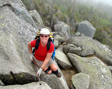
It was quite a climb, which started out in the pouring rain. The main effect of the rain, other than making wet hikers, is that the trai, which is generally the lowest point in the immediate area, becomes a stream. In the case of the ascent of Mt Katahdin was steep mountain boulder filled stream.


By the time we reached the treeline the rain had slowed to a drizzly mist with occasional heavier outbursts. But the weather wasn't the problem at this stage,it was the rocks. The rocks that I had to climb up and over on this thing they call a trail up the mountain! They ranged from huge slabs of slickrock that had iron rungs to assist clambering up them, to steep cliffs of rough limestone, to boulders of all sizes.
The mist obscured the mountain we were climbing, and mainly we could only see the next outcrop to be climbed. For several hours my utterances were mainly "there is no way they're expecting me to climb THAT" and "this has got to be the last one" and "we must be at the top after this", but there was always another steep pile of rocks waiting for me in the mist.

Maybe it was a good thing that the mist was there. This mountain was high - over 4000 ft of elevation change from the campsite at the bottom to the summit, in a little over 5 miles of hiking. The top, when we got there, was cold, wet, misty, and totally worth the hike!

The sign at the summit is the official start of the Appalachian Trail for me. Apparently the five mile uphill slog doesn't even count in my mileage. We spent a short while on the summit, during which time the sky brightened for a few moments and it seemed to get warmer. Of course, as soon as I had removed a few outer clothing layers the mist turned to hail and I immediately bundled up again.

As we descended down on the the plateau below the summit the sun did actually break through briefly. Even better, the hole in the cloud revealed the landscape below, far below us. It is very high up! Fortunately the cloud closed up again for the descent back down to the treeline. I think not being able to see around and below me during the descent was probably easier.


View more photos in my Picasa album
Monday, June 16, 2008

Millinocket, ME

We made it to Maine. It was kind of long and involved a taxi, two planes, a rental car, an overnight in Bangor, a bus, and a shutle provided by the Appalachian Trail Lodge in Millinocket. The most nerve racking part was hoping the boxes with our backpacks and their contents made the same flight cnnections as we did. It may be anal, but I actually stood in the window of both airports watching the baggage loading and unloading processes for the boxes. It worked. They made it.

The AT Lodge is great, a hiker bunkhouse which at this time of year caters mainly to hopeful southboud (SOBO) hikers headed for Katahdin. The lodge provides shuttles from the bus stop out on Interstate 95, and to Baxter State park for hikers. They owners also own a cafe in town, the AT Cafe, which provides a great breakfast and other meals. Our driver Paul handed us menus when we got in his truck then called in our dinner orders so our food was ready when we arrived. They provide a great service.

We spent today hunting down more bug protection. We have bug spray, but we met a hiker here who is absolutely covered in mosquito bites. Both of us had considered bug net clothing for the hike, but had rejected the idea as overkill. We've kind of changed our policy on that, and were fortunate to find suitable bug shirts, pants and headnets in the local hardware store. We aslo picked up the last few things we needed for the hike, and our fuel canisters which had been mailed ground to ourselves.


The adventure begins...

View more photos in my Picasa album

Tuesday, June 10, 2008

Pisgah National Forest, NC

Plans change, but sometimes that just works out for the best. We had intended to hike a section of the AT Hot Springs and Erwin as a shakedown hike. However it was well over 100 degrees during our weekend in Hot Springs. Being up on the top of a ridgeline with limited access to water and potential afternoon thunderstorms just didn't sound so much fun in those temperatures. I know I'm supposed to be testing myself and especially my knee, but we're going to be doing enough suffering the elements during the actual AT hike. I'd just as soon concentrate on testing my knees for a couple of days as my sweat glands!

Ed and Karen suggested that hiking in the Pisgah NF would provide the terrain we needed to test out my knee, plus provide a number of pleasant loop hikes along creeks that would probably be more fun. I was easily convinced. They offered their houise to us for a night, during which time we poured over maps and selected a couple of trails to try.

In the late afternoon we set out for Harper Creek. We arrived around 6pm and hiked a mile or so before making camp. We were very lucky to see first a single blue firefly and then several of them, glowing long and low to the ground. They are quite rare and we felt very lucky to see them. Soon after that we were hurried to bed by a thunderstorm. We had agreat couple of days hiking in and around the creek, up steep slippery ravine slopes, through rocky boulder creeks and over slickrock. Best of all we really had no schedule and ended up relaxing away the hot afternoons by the creek resting and swimming in waterholes.

My knee has proved itself: it's borne the weight of the pack, it's been jolted, twisted, jerked and put under strain under realistic backpacking conditions and it's acted just like a knee should. I have no pain or swelling. It's time to quit lollygagging around and get ourselves up to Katahdin to start hiking the Appalachian Trail!

Saturday, June 7, 2008

Hot Springs, NC

I know why they call it Hot Springs! It's definitely hot.

We've arrived in Hot Springs for a hammock hangout meeting here. My hiking partner Brian wanted to spend a weekend here hanging out with his buddies before we leave for the AT. As a dedicated ground dwelling tent owner I wasn't sure how I'd be welcomed, and I did actually try a hammock for an afternoon nap, but I wasn't able to fall asleep, and I'm sure I couldn't spend a whole night like that.

Our plan is to spend the weekend here, then set out on the Appalachian Trail from here to do a shakedown hike. The main purpose is to test out my knee. I've been hiking on it, but not with the full weight of my pack yet, and even if I'd had a chance to hike with it, I couldn't match the hilly/mountainous terrain of the AT while I was still in Florida. The plan is to load ourselves up with a couple of days of food and all the gear we'll need for the AT and get out to test my knee. If I can't take the uphill/downhill hiking there are several places we can bail off the trail. If I can't do it, Brian will just go on alone to Maine without me. That's a sad thought, and hard for me to accept it might happen, but there is no point going up to Maine and getting myself stuck on Mt Katahdin or in the 100 mile wilderness.

The other purpose of the shakedown is to go one last time through our gear to make sure we're not carrying anything we don't need, and are carrying everything we do need. On that point, my backpack spontaneously delaminated on both the zips tonight. So now I have a pack with a top and front zips that are useless. I'm sure I can manage just for the shakedown, but somehow I'm going to have to get my pack replaced before we can head north.

Monday, June 2, 2008

So is that good news, or bad?

My MRI came back. It's not the meniscus. Great on that. However, apparently, apart from my cartilage being old and creaky, which I knew, and there isn't much I can do about right now except keep taking the Glucosamine, I have some additional issues. A fracture, a "bone island" (doesn't that sound like somewhere you'd find skeletons and buried treasure?), a sprain, and a small tear on the ACL.
The small tear and the old cranky cartilage I've known about for a long time. The tear has always been described as "small" and doesn't appear any bigger than before, so I know it alone won't stop me hiking. The cartilage thing, as descibed above, is just wear and tear, and possibly a little bit of genetics. I have my Dad's knees, and his have been replaced when he was in his late 60s. I hope mine last that long. The bone island is apparently a patch of non growing bone or cartilage in the midst of normal bone. It is basically benign, and shows up as a light spot on xrays and MRI's and as long as it's small and stays that way and exhibits no other symptoms it can just be left alone.

So the additional issues are the fracture and the sprain. The recent injury happened while taking a gentle evening run, there was no impact or sudden onset of pain, just a "not quite right" feeling, so I can't imagine that the fracture occurred then. I suspect it occurred when I made a spectacular fall in Ft Lauderdale airport on my way to Jamaica in February. I didn't get the knee looked at then, but went back to hiking a week later with no ill effects, though I now believe that was most likely when the fracture occurred.

So, the only recent injury seems to be the sprain and associated bruising, fluid, etc. The pain from this appears to have eased off as a sprain should, with rest, icing, etc.. This is definitely a different knee than the one I flew home with a couple of weeks ago.

The result of all this is that I'm even more determined to hike in real life conditions to test if I can really hike. The backpack for a week plan still stands. We're heading for the hills of NC next week. If I can hike pain free with a fully loaded pack for 10 or so miles a day, then I'm going on up to Maine to start hiking SOBO. If I can't, well, I'll have to return to Florida and cash in my Rx for an orthopedic consult. Lets hope it doesn't come to that.