The last few days have not been good to me! Right now I'm sitting in Woodstock, VT behind the wheel of a rental car bawling my eyes out because I just had to leave my good friend and hiking partner behind on the trail to hike on without me. I feel like half of me is missing.
Since we left Hanover I have been in pain. My knees, which have given so much in the past 400 miles or so of rocks, roots, and high steps have not adapted to this new "gentler" sloping terrain. I feel at times like I'm having to learn to walk all over again. I may not have helped the situation by switching to new shoes in Hanover. They're the same as before, but these have not been mud soaked and worn to a flexibility like the previous pair. My feet just don't feel like they're making contact the ground correctly. Add my current situation and pain to the realization that we are now massively behind schedule, and in order to make up miles and have a hope of finishing (or at least getting through the high altitude of the Smokeys (NC)) before really bad winter weather, and we had already discussed the need to do longer days, in shorter daylight hours. We did some bigger faster mileage yesterday, and I paid for it last night. It's turning cooler, I was cold every time I stopped for breaks yesterday, and this morning was downright cold. A daily diet of painkillers is making sick to my stomach and I can't keep my food dowm. Having enough energy to hike when I can't eat sufficiently is a joke. I was hardly even able to function to get my pack packed in the cold this morning.
I'm feeling guilty that I'm slowing Chill down, he can hike much harder and longer than I can when his back isn't causing him pain and my slowing us down may ultimately cost him his hike. We had agreed before the hike that if this situation came up that we would split up. Now is the time to face up to that situation. I was so sure that the lower terrain and gentler trail would be the end of my knee problems, but it appears that my poor knees dislike sloping lower hills even more than jagged rocky steep mountains.
I told Brian to go on without me, but of course, he didn't want to leave me sitting there sick, so we managed to get ourselves to Woodstock, VT. Not the cheapest place on earth to be stranded with no plan! Now that I'm not hiking and and eating food that didn't have to be rehydrated, and sleeping in a warm bed I'm feeling physically better, except for my knees and back, but I know I'm not up to continuing. I have looked at options for getting back to Florida, staying somewhere round here a while, or skipping down the trail some miles and waiting out my knees a while. There is no cheap option, but in the course of looking at the options I did figure out that a one way car rental to somewhere, was probably the best option. We spent some time running errands in the car: picking up bounce boxes I'd mailed ahead, doing laundry and resupply for Brian, copying photos to CDs, etc., but we were only postponing the inevitable. Brian has a trail to hike, and I can't continue right now.
The question of where to drive to has been resolved by my good freind Mary. She is in New York state somwhere, and has offered a bed for as long as I need it. It's a couple couple hundred miles from the AT, but if I can drive there, I can drive back, right? I'd love to see her for a while, and it could still keep the possibility of returning to the trail alive, which is not likely to happen if I return to Florida for a break.
I'll be driving there as soon as I can clear my eyes enough to see the road.
View more photos in my Picasa album
Showing posts with label AT. Show all posts
Showing posts with label AT. Show all posts
Friday, September 12, 2008

Saturday, August 30, 2008
Glencliffe, NH
We're finished with the Whites, and just have a few more days to hike in New Hampshire. Since getting back on the trail at Lincoln the mountains have been slightly kinder, Mt Moosilauke was the biggest, and it was a very pleasant experience.
On our first afternoon out of Lincoln we had a strange encounter with a hiker we'll just call "dogman". Ascending Mt Kinsman, we started hearing occasional single dog barks, and assumed we were approaching the campsite. Iinstead, a lone male hiker appeared traveling in the opposite direction. Not seeing a dog, we just thought it was further up the trail, but as he passed he explained that he had heard that bears had been spotted in this area so he barks every couple of steps to scare them away. We thought that was kind of strange anyway, as we love to see and encounter wildlife on the trail, but what was really hilarious was hearing him gradually disappear down the trail below, with the barks receding in the distance. What a hoot (or a woof)!
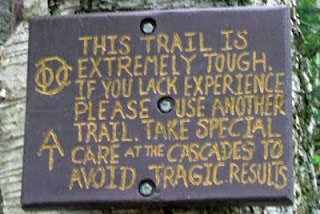
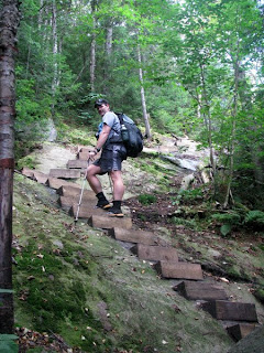
We were also amused by the dire warnings at the bottom of the Moosilauke trail, warning the inexperienced not to attempt the hike. As we ascended we became more amused; this was one of the easiest ascents we've had so far. The entire uphill along the cascades had wooden steps bolted into the slickrock, and rails, etc. Sweet!
The mountain was very busy with tourists, but apparently most had come up an easier trail which joined ours just before the summit. We had another great 360 view from the top, then a nice descent which brought us down off the mountain into our first meadow in 400 miles. That's a very strange feeling after so much mountain and forest.
View more photos in my Picasa album
On our first afternoon out of Lincoln we had a strange encounter with a hiker we'll just call "dogman". Ascending Mt Kinsman, we started hearing occasional single dog barks, and assumed we were approaching the campsite. Iinstead, a lone male hiker appeared traveling in the opposite direction. Not seeing a dog, we just thought it was further up the trail, but as he passed he explained that he had heard that bears had been spotted in this area so he barks every couple of steps to scare them away. We thought that was kind of strange anyway, as we love to see and encounter wildlife on the trail, but what was really hilarious was hearing him gradually disappear down the trail below, with the barks receding in the distance. What a hoot (or a woof)!


We were also amused by the dire warnings at the bottom of the Moosilauke trail, warning the inexperienced not to attempt the hike. As we ascended we became more amused; this was one of the easiest ascents we've had so far. The entire uphill along the cascades had wooden steps bolted into the slickrock, and rails, etc. Sweet!
The mountain was very busy with tourists, but apparently most had come up an easier trail which joined ours just before the summit. We had another great 360 view from the top, then a nice descent which brought us down off the mountain into our first meadow in 400 miles. That's a very strange feeling after so much mountain and forest.
View more photos in my Picasa album
Friday, August 22, 2008
Lincoln, NH
The White Mountains were a mixture of hot & sticky, stormy and rainy, and cold and windy. We crossed paths with a massive bull moose with a rack at least 8 feet wide, stealth camped on a really stormy night, spent the night in Zealand Falls hut as paying guests, and Brian earned himself a new trail name when he let himself get hyperthermic. We're in Lincoln, NH now, enjoying the hospitality of Chet, a former hiker who was injured in a camping stove related fire in his former home, and now allows hikers to stay in his bunkroom converted garage.
We spent a lot of this last section hiking with Abby. She had never stealth camped before, and decided that a noce dry warm night would be a good time to try it. We picked a site on the banks of Thoreau Stream, and each set up our camps on a tier od the banks. Brian is bunking in with me in my tent for the time being. He has shipped his hammock ahead to Glencliff to save carrying the weight, because there are fewer hanging opportunities in the Whites. He said he'd be fine on the ground with his tarp, but it was a little buggy, and I couldn't just leave him to feed the mosquitoes all night. Shortly after we retired to bed for the night I'm sure he became even more gald of my hospitality becasue the sky just opened, with heavy rain, constant thunder and lightning. When we woke in the morning after a fitful night's sleep, we were floating on a puddle bigger than my tent. Amazingly, the bathtub floor of my tent had saved us from wet everything. We had to be really careful extracting ourselves and all our gear to keep the floating floor (think waterbed) from collapsing in and flooding everything. Abby slept under her tarp, and managed somehow to stay mainly dry.
After such a sleepless night, wet start, and a now cold and blustery day we really didn't want to get up on the ridge in the storm. When we reached Zealand Falls hut after only a few miles we decided to pay for a night's stay there. It's expensive, but the main benefit was being able to claim a bunk immediately and climb under several heavy wool blankets for an afternoon nap. The place was OK, but I certainly wouldn't want to make a habit of staying in the huts. All you get for $100 per person is a bunk in an unheated room with 20 or so other people, 3 blankets and a pillow. There are toilets, but in the bathrooms no hot water, and signs prohibiting sponge baths! Two meals are included in the price and dinner was pretty good, but I think the portions were rather small considering everyone there had hiked in, and was paying close to $100 to stay. Abby got her work for stay, continuing in her quest to work for stay every hut in the Whites.
Next morning we got an early start out and it was actually sunny, but very windy and cold, especially on the exposed summits of the ridge we were walking. We had a scary episode of Brian suffering quite an advanced stage of hyperthermia, even though it was probably the warmest part of the day when it occurred. We had somehow got seperated, I thought he was ahead of me, and was hurrying to catch him, and he thought I was behind, so was dawdling until another hiker told him I had passed by some time ago. He ran (uphill) to catch me, and was swety when he finally found me. We stopped for a short break, and probably should have broken out the stoves to have a hot drink right there, it was very chilly and blustery, despite the sunshining. However, we decided against hot drinks, opting to walk faster to warm up instead. That was a big mistake. Brian outhikes me easily, and as I approached the next peak in my own version of hiking fast I had not seen him in quite a while.
It was the first time I had had a clear long distance view of the Presifential Range, and as I lingered on an outcropping ledge I stopped to take pictures back to Mt Washington. As I started back hiking to the summit I spotted something odd beneath the trailside bushes. At first glance I thought it was a hiker sleeping there. That seemed weird, worth a second glance. That glance brought me to a screeching halt. It was Brian, not sleeping, but laying in the mud of a waterbar runoff. He'd removed all his clothes except his shorts, and had the contents of his pack strewn all around him. His skin was white as a cotton sheet, with the exception of his face which was bright red. When I tried to get him up he was muttering strange stories about bears, making camp, having to give all his clothes and food away. Very strange, and quite scary.
I realized that he was probably hyperthermic, and managed to get him to put his clothes back on and wrap his sleeping bag around him. At the same time I was unpacking my own pack to get out my stove and boil hot water. Eventually he regained lucidity after about a liter of hot cocoa. He had little memory of what had happened, but does remember hearing about a bear that had lost it's fur and needed to borrow his clothes. He had been trying to catch the bear when he thought it had got dark, and decided to "make camp"! For the remainder of the day's hike he staggered around like a drunk, and complained of the worst "hangover" ever. Not that there was any alcohol involved, just the major headache and disassociated feeling. I think we had a close call, but we did walk several further miles to the next hut to get hot food and drink in both of us, then on to the next shelter for the night.
Next day we had some serious hiking to do. Brian was still feeling tender, but we were out of food, so had no choice but to make it to town. The last mountains Garfield and Lafayette, and the Franconia ridge we steep and hard, but very rewarding. It was a beautiful day, still breezy, but not as cold as yesterday, and quite pleasant to sit in if you could get out of the wind. Mt Lafayette was crowded with tourists. This is a steep hike up from the road below, but relatively short, and obviously very popular on a weekend for day hikes.
View more photos in my Picasa album
We spent a lot of this last section hiking with Abby. She had never stealth camped before, and decided that a noce dry warm night would be a good time to try it. We picked a site on the banks of Thoreau Stream, and each set up our camps on a tier od the banks. Brian is bunking in with me in my tent for the time being. He has shipped his hammock ahead to Glencliff to save carrying the weight, because there are fewer hanging opportunities in the Whites. He said he'd be fine on the ground with his tarp, but it was a little buggy, and I couldn't just leave him to feed the mosquitoes all night. Shortly after we retired to bed for the night I'm sure he became even more gald of my hospitality becasue the sky just opened, with heavy rain, constant thunder and lightning. When we woke in the morning after a fitful night's sleep, we were floating on a puddle bigger than my tent. Amazingly, the bathtub floor of my tent had saved us from wet everything. We had to be really careful extracting ourselves and all our gear to keep the floating floor (think waterbed) from collapsing in and flooding everything. Abby slept under her tarp, and managed somehow to stay mainly dry.
After such a sleepless night, wet start, and a now cold and blustery day we really didn't want to get up on the ridge in the storm. When we reached Zealand Falls hut after only a few miles we decided to pay for a night's stay there. It's expensive, but the main benefit was being able to claim a bunk immediately and climb under several heavy wool blankets for an afternoon nap. The place was OK, but I certainly wouldn't want to make a habit of staying in the huts. All you get for $100 per person is a bunk in an unheated room with 20 or so other people, 3 blankets and a pillow. There are toilets, but in the bathrooms no hot water, and signs prohibiting sponge baths! Two meals are included in the price and dinner was pretty good, but I think the portions were rather small considering everyone there had hiked in, and was paying close to $100 to stay. Abby got her work for stay, continuing in her quest to work for stay every hut in the Whites.
Next morning we got an early start out and it was actually sunny, but very windy and cold, especially on the exposed summits of the ridge we were walking. We had a scary episode of Brian suffering quite an advanced stage of hyperthermia, even though it was probably the warmest part of the day when it occurred. We had somehow got seperated, I thought he was ahead of me, and was hurrying to catch him, and he thought I was behind, so was dawdling until another hiker told him I had passed by some time ago. He ran (uphill) to catch me, and was swety when he finally found me. We stopped for a short break, and probably should have broken out the stoves to have a hot drink right there, it was very chilly and blustery, despite the sunshining. However, we decided against hot drinks, opting to walk faster to warm up instead. That was a big mistake. Brian outhikes me easily, and as I approached the next peak in my own version of hiking fast I had not seen him in quite a while.
It was the first time I had had a clear long distance view of the Presifential Range, and as I lingered on an outcropping ledge I stopped to take pictures back to Mt Washington. As I started back hiking to the summit I spotted something odd beneath the trailside bushes. At first glance I thought it was a hiker sleeping there. That seemed weird, worth a second glance. That glance brought me to a screeching halt. It was Brian, not sleeping, but laying in the mud of a waterbar runoff. He'd removed all his clothes except his shorts, and had the contents of his pack strewn all around him. His skin was white as a cotton sheet, with the exception of his face which was bright red. When I tried to get him up he was muttering strange stories about bears, making camp, having to give all his clothes and food away. Very strange, and quite scary.
I realized that he was probably hyperthermic, and managed to get him to put his clothes back on and wrap his sleeping bag around him. At the same time I was unpacking my own pack to get out my stove and boil hot water. Eventually he regained lucidity after about a liter of hot cocoa. He had little memory of what had happened, but does remember hearing about a bear that had lost it's fur and needed to borrow his clothes. He had been trying to catch the bear when he thought it had got dark, and decided to "make camp"! For the remainder of the day's hike he staggered around like a drunk, and complained of the worst "hangover" ever. Not that there was any alcohol involved, just the major headache and disassociated feeling. I think we had a close call, but we did walk several further miles to the next hut to get hot food and drink in both of us, then on to the next shelter for the night.
Next day we had some serious hiking to do. Brian was still feeling tender, but we were out of food, so had no choice but to make it to town. The last mountains Garfield and Lafayette, and the Franconia ridge we steep and hard, but very rewarding. It was a beautiful day, still breezy, but not as cold as yesterday, and quite pleasant to sit in if you could get out of the wind. Mt Lafayette was crowded with tourists. This is a steep hike up from the road below, but relatively short, and obviously very popular on a weekend for day hikes.
View more photos in my Picasa album
Sunday, August 17, 2008
Crawford Notch, NH
My trip over the Presidentials was fun, and not nearly as hard as I had expected, mainly due to a change in the weather.
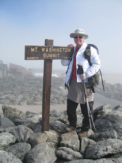 Finally, after all the rain, I lucked out with decent waether in the area with the most unpredictable weather on the trail! That's not to say it was all sunny, and the wind didn't howl, but it was at least clear for the most part, and particularly on my traverse over Mt Washington. The summit of Washington was totally socked in in fog and cloud when I arrived. It was just barely above freezing, and I was wearing literally everything I was carrying: long pants, sweater, vest and down jacket, buff ear cover, wool hat, gloves. Everything! But as I stood waiting for my summit shot the sun started to break through, apparently for the first time in several weeks, and the temps rose a little.
It was still windy though. I managed to remove a couple of the layers, coat, gloves and the hat I think. I spent the night at Lakes of the Clouds hut doing a work for stay. This hut was definitely a different experience than Carter Hut. The croo were at least civil to the hikers, though I still wouldn't consider it actually friendly. The food was better than Carter hut too. We even got brownies, and a couple of differnt meats with our dinner. It's a much more satisfying meal when it's not all carbs. I actually almost missed the dinner call becasue I was outside, where it was extremely wind and cold again, but there was a beautiful sunset.
 I cleaned the stove for my work for stay. I didn't mind the work, but was worried about getting my only clothes all greasy from the stove. I met Abby, another female SOBO at the hut. She's a lot younger, and is hiking solo, which is very courageous at her age and with little backpacking experience.
The remainder of the Presidentials was pretty routine. Yes, there were sttep rocky trails, but soome gorgeous scenery, and it was predominantly warm and sunny. I had left Brian behind in Gorham. He had some kind of a funk on, and decided he wanted more time in town. He didn't seem sick or anything, so I figured this was his way of telling me it was time for us to go our seperate ways. That's OK with me, because that was our agreement in the beginning, to just hike together as long as we both wanted it, and if the time came to split up we would do so. I just wish he could have actually said that instead of just hanging back though!
I actually enjoyed hiking alone. I think I talked to more people on this stretch than I have on others, but that's probably just because there are more people here than we have seen so far. This a very popular area, and of course it is the middle of summer (freezing temperatures and all!).
The trickiest part of this hike was the descent down Webster Cliffs. It wasn't as bad as many of the slick descents I've had so far, but some of the NOBOs had made it out to be much more dangerous than it was. Boy, are they in for a surprise when they hit Maine! The only reason it was tricky for me is that I had decided to tackle it late in the day, instead of stopping at Mizpah hut, which would have been the smart thing to do. There was a storm brewing and the top of the cliffs were very exposed, so I continued down in a light rain instead of being stuck on the top in a storm. The rocks granite rocks were very slick when wet, and it was getting late in the day. I knew I'd have to hitch hike to get to a campground when I reached the road, and really wanted to get down before dark, and preferably before it stormed.
I did make it, and got a ride from a nice French Canadian man out for a weekend camping trip with his son. He was a hiker, and was looking for a campground too, so they were happy to have me join them finding it. I lost him in the crowd at the check in, so I don't even know if he is staying here. I was saved from the long line by Richard, the campground owner. He easily identified me as a backpacker in the line (maybe the backpack, or maybe I stink again already?) and pulled me over to the side. He gave me a towel, shower tokens, and directions to the bunkhouse, and told me to get settled and shower (I guess maybe it was the stink!!) and return to register after the crwod had gone down. That was nice.
I was actually the only hiker in the bunkhouse the first night. What a great place: a fully enclosed hut with 4 sets of bunkbeds, table, shairs, individual bunklights, etc. The showers were hot and clean, a little slippery underfoot though. I fell and jarred my right shoulder pretty badly. Nice bruise on my thigh too. The fall caused me to zero for a day, I hadn't slept well, knees, hips and right shoulder weren't happy with me, and I had to take ibruprofen to get some rest.
For my second night here the bunkhouse was completely full. First to join me was Abby, who had work for stayed at Mizpah hut the night before. She is on a quest to work for stay at every hut in the system. She had had a hairy hike down the mountain today. She had been put off by the NOBOs stories about Webster cliffs so had decided to try an alternate route down, but ended up following false trails and having to ford a river several times to reach the road. I told her she needs to have more confidence in herself after what she has already achieved to get here and not be so freaked out by NOBOs!
As the day progressed more hikers arrived. The storms that never materilzed yesterday came out in full force today, and that will always fill up a hiker hostel or bunkhouse. By dark the bunkhouse was full. Just as we were all preparing to settle down, who walks in? Brian. He had been trapped up on Mt Washington by the lightning storms. Unable to hike on, he had finally bailed off the mountain in a car with a couple of guys who then drove him here. Today, as I write this, he has taken the Cog Railway up to the top of Mt Washington and will hike back to here tonight. I'm taking another zero day, as is Abby, and we'll all hike out tomorrow morning, if the weather cooperates.
View more photos in my Picasa album
 Finally, after all the rain, I lucked out with decent waether in the area with the most unpredictable weather on the trail! That's not to say it was all sunny, and the wind didn't howl, but it was at least clear for the most part, and particularly on my traverse over Mt Washington. The summit of Washington was totally socked in in fog and cloud when I arrived. It was just barely above freezing, and I was wearing literally everything I was carrying: long pants, sweater, vest and down jacket, buff ear cover, wool hat, gloves. Everything! But as I stood waiting for my summit shot the sun started to break through, apparently for the first time in several weeks, and the temps rose a little.
 It was still windy though. I managed to remove a couple of the layers, coat, gloves and the hat I think. I spent the night at Lakes of the Clouds hut doing a work for stay. This hut was definitely a different experience than Carter Hut. The croo were at least civil to the hikers, though I still wouldn't consider it actually friendly. The food was better than Carter hut too. We even got brownies, and a couple of differnt meats with our dinner. It's a much more satisfying meal when it's not all carbs. I actually almost missed the dinner call becasue I was outside, where it was extremely wind and cold again, but there was a beautiful sunset.
 I cleaned the stove for my work for stay. I didn't mind the work, but was worried about getting my only clothes all greasy from the stove. I met Abby, another female SOBO at the hut. She's a lot younger, and is hiking solo, which is very courageous at her age and with little backpacking experience.
 The remainder of the Presidentials was pretty routine. Yes, there were sttep rocky trails, but soome gorgeous scenery, and it was predominantly warm and sunny. I had left Brian behind in Gorham. He had some kind of a funk on, and decided he wanted more time in town. He didn't seem sick or anything, so I figured this was his way of telling me it was time for us to go our seperate ways. That's OK with me, because that was our agreement in the beginning, to just hike together as long as we both wanted it, and if the time came to split up we would do so. I just wish he could have actually said that instead of just hanging back though!
I actually enjoyed hiking alone. I think I talked to more people on this stretch than I have on others, but that's probably just because there are more people here than we have seen so far. This a very popular area, and of course it is the middle of summer (freezing temperatures and all!).
The trickiest part of this hike was the descent down Webster Cliffs. It wasn't as bad as many of the slick descents I've had so far, but some of the NOBOs had made it out to be much more dangerous than it was. Boy, are they in for a surprise when they hit Maine! The only reason it was tricky for me is that I had decided to tackle it late in the day, instead of stopping at Mizpah hut, which would have been the smart thing to do. There was a storm brewing and the top of the cliffs were very exposed, so I continued down in a light rain instead of being stuck on the top in a storm. The rocks granite rocks were very slick when wet, and it was getting late in the day. I knew I'd have to hitch hike to get to a campground when I reached the road, and really wanted to get down before dark, and preferably before it stormed.
I did make it, and got a ride from a nice French Canadian man out for a weekend camping trip with his son. He was a hiker, and was looking for a campground too, so they were happy to have me join them finding it. I lost him in the crowd at the check in, so I don't even know if he is staying here. I was saved from the long line by Richard, the campground owner. He easily identified me as a backpacker in the line (maybe the backpack, or maybe I stink again already?) and pulled me over to the side. He gave me a towel, shower tokens, and directions to the bunkhouse, and told me to get settled and shower (I guess maybe it was the stink!!) and return to register after the crwod had gone down. That was nice.
I was actually the only hiker in the bunkhouse the first night. What a great place: a fully enclosed hut with 4 sets of bunkbeds, table, shairs, individual bunklights, etc. The showers were hot and clean, a little slippery underfoot though. I fell and jarred my right shoulder pretty badly. Nice bruise on my thigh too. The fall caused me to zero for a day, I hadn't slept well, knees, hips and right shoulder weren't happy with me, and I had to take ibruprofen to get some rest.
For my second night here the bunkhouse was completely full. First to join me was Abby, who had work for stayed at Mizpah hut the night before. She is on a quest to work for stay at every hut in the system. She had had a hairy hike down the mountain today. She had been put off by the NOBOs stories about Webster cliffs so had decided to try an alternate route down, but ended up following false trails and having to ford a river several times to reach the road. I told her she needs to have more confidence in herself after what she has already achieved to get here and not be so freaked out by NOBOs!
As the day progressed more hikers arrived. The storms that never materilzed yesterday came out in full force today, and that will always fill up a hiker hostel or bunkhouse. By dark the bunkhouse was full. Just as we were all preparing to settle down, who walks in? Brian. He had been trapped up on Mt Washington by the lightning storms. Unable to hike on, he had finally bailed off the mountain in a car with a couple of guys who then drove him here. Today, as I write this, he has taken the Cog Railway up to the top of Mt Washington and will hike back to here tonight. I'm taking another zero day, as is Abby, and we'll all hike out tomorrow morning, if the weather cooperates.
View more photos in my Picasa album
Tuesday, August 12, 2008
Return to Gorham
This last section into the start of the White mountains was miserable. It never stopped raining, was cold, and the nasty steep terrain and slickrock didn't magically disappear yet either.
Our first day out of Gorham we managed only a couple of miles in a drenching downpour before taking refuge in the first shelter, which we shared with a homeless man, but no other hikers. Next morning, we staggered on. Literally in Brian's case. His back was hurting so badly he had lost the feeling in his right leg. We spent an interminably slow morning of forward progress, he wrenching his unresponsive leg forward one step at a time, and I following along, unable to do or say anything to help with the pain. By evening we were exhausted, cold, tired and wet, and just grateful to reach the next shelter.
For our third day, Brian was at least in less pain. However, it was still raining and cold and very cold. Stopping for breaks was almost impossible, and very uncomfortable at the least. We were ready for a night indoors, but the only option to do so was to stop at Carter Notch hut. The huts system in the Whites is a thorn in a thru hiker's side. They are expensive, often full, and are staffed by a "croo" of students that have a reputation for not wanting thru hikers in their huts. We had planned to avoid the huts if at all possible, but in our current situation, it appeared we had no choice.
We were determined to go into the hut with an open mind, but lets just say that despite all our efforts to make this a positive experience, it was not so. I won't go into deatil, but the list of list of atrocities includes being forced back out into the cold and rain while the paying guests ate dinner, having our clothes which had been hung up to dry, being wadded up and thrown where there was no chance they would dry, unpalatable and unhygenically cooked food, e. coli in the supposedly potable water, and a general sense of disdain from the croo. Hopefully we can get through the Whites without having to repeat this experience.
We left the hut in the only brief sunshine of this section, but it did not last. By the time we had ascended out of the notch it was raining again. The Wildcat peaks were frustrating, steep and slick, and it was so cold that my fingers were blue. I sat at the bottom of one vertical rock face and cried. I could not even feel my fingers, yet I was supposed to climb hand over hand with them and risk my life on them? Eventually, knowing I had no choice I did it anyway.
My life was saved that day by a gondola. At the top of the last Whitecap peak was a gondola service running down to the ski resort below. Somehowm the moment I set eyes on this high wire saviour the sun also came out. It was still cold though, and windy too. Afraind that the gondola service would be halted at any moment due to the wind, I was anxious to jump onto it and ride back to civilization.
View more photos in my Picasa album
Our first day out of Gorham we managed only a couple of miles in a drenching downpour before taking refuge in the first shelter, which we shared with a homeless man, but no other hikers. Next morning, we staggered on. Literally in Brian's case. His back was hurting so badly he had lost the feeling in his right leg. We spent an interminably slow morning of forward progress, he wrenching his unresponsive leg forward one step at a time, and I following along, unable to do or say anything to help with the pain. By evening we were exhausted, cold, tired and wet, and just grateful to reach the next shelter.
For our third day, Brian was at least in less pain. However, it was still raining and cold and very cold. Stopping for breaks was almost impossible, and very uncomfortable at the least. We were ready for a night indoors, but the only option to do so was to stop at Carter Notch hut. The huts system in the Whites is a thorn in a thru hiker's side. They are expensive, often full, and are staffed by a "croo" of students that have a reputation for not wanting thru hikers in their huts. We had planned to avoid the huts if at all possible, but in our current situation, it appeared we had no choice.
We were determined to go into the hut with an open mind, but lets just say that despite all our efforts to make this a positive experience, it was not so. I won't go into deatil, but the list of list of atrocities includes being forced back out into the cold and rain while the paying guests ate dinner, having our clothes which had been hung up to dry, being wadded up and thrown where there was no chance they would dry, unpalatable and unhygenically cooked food, e. coli in the supposedly potable water, and a general sense of disdain from the croo. Hopefully we can get through the Whites without having to repeat this experience.
We left the hut in the only brief sunshine of this section, but it did not last. By the time we had ascended out of the notch it was raining again. The Wildcat peaks were frustrating, steep and slick, and it was so cold that my fingers were blue. I sat at the bottom of one vertical rock face and cried. I could not even feel my fingers, yet I was supposed to climb hand over hand with them and risk my life on them? Eventually, knowing I had no choice I did it anyway.
My life was saved that day by a gondola. At the top of the last Whitecap peak was a gondola service running down to the ski resort below. Somehowm the moment I set eyes on this high wire saviour the sun also came out. It was still cold though, and windy too. Afraind that the gondola service would be halted at any moment due to the wind, I was anxious to jump onto it and ride back to civilization.
View more photos in my Picasa album
Sunday, August 3, 2008
New Hampshire (at last!!!!)
 I'm finally out of Maine and into New Hampshire. Not that it made much difference in trail conditions, it was still raining, boggy, buggy, and slick, but it's a major milestone to have completed the first State.
 In this last section of Maine we climbed a fire tower on the top of Old Speck Mountain, and hiked the reputed hardest maile of the AT, through Mahoosuc Notch. The fire tower was fun, if a little scary, and the Notch, in the pouring rain and a lightning storm was not! The reaminder of the section was just more of the same old Maine, now running into New Hampshire.
On a happier note, as we crossed our last mountain on the way down into Gorham we found a few berries left behind by a bear that had very recently. There were the usual blueberries, but also blackberries and raspberries. I helped myself to the remnants of the bear's feast. Yum!
View more photos in my Picasa album
Tuesday, July 29, 2008
Andover, ME

Ah day hiking! We've spent the past several dasy staying at the Pine Ellis hostel in Andover and slack packing, or day hiking with just lunch, snacks and rain gear, being dropped off and picked up each day to return to the hostel and a dry bed. Our driver for this series of hikes was Ken. A great guy. He waited patiently at the end of each day for us, as we were invariably late, and he was always early.
The main reason for doing all the slacking was the rain. Where previously it had been slightly annoying, since Rangeley it has been downright drenching. When Ken first picked us up at the Rte 17 road crossing we were soaked to the skin. I could not have been wetter if I'd been dipped in a lake! I felt very guilty about getting into Ken's minivan as wet as I was, but of course he refused my offer to strip off before I got in!
View more photos in my Picasa album
Wednesday, July 23, 2008
Rangeley, ME
Since leaving Stratton it has actually rained every afternoon. Its getting rather frustrating, not to mention very stinky, getting wet every day and it being too damp to dry things out overnight. The only time that anything is getting dry is on the occasional hot sunny afternoon, when everything also gets sweaty, salty and stinky!
We've come to Rangeley for the night to do some laundry and resupply for the next couple of days. We met a really nice couple out hiking with their three kids at Piazza Rock, and they offered us a ride into town. It was well appreciated, but as we had no idea where we intended to go when we got there we just stopped at the first hotel we saw. It's a little expensive, but definitely worth it now I'm lazing in bed in the late morning. I showered last night, have had a whole queen size bed with crisp clean sheets to myself all night. I'm not anxious to put my stinky clothes back on, but as the laundry is on the way back to the trail there is really not choice but to just pack up and start back that way. We'll wash as much as we can when we get there, then stop for resupply at the grocery on the edge of town and get straight back to the trail. I don't hold out much hope of staying dry, we had a big storm here last night and it's still drizzling now.
Brian has been feeling increasingly better each day since we left Stratton, but we now think that he probably had some kind of stomach bug, because I got sick the first day out from Stratton. I wasn't as bad as he had been, but had to call the second day's hiking short due to lack of energy and stomach cramps.
We had a wildlife sighting in our camp that day, I woke to Brian poking me through the tent door. It was 5:30am and he had been awoken by a breaking stick. The first thing he saw when he opened his eyes was the stick breaker, a moose calf, carefully picking its way around the lines for the tarp. He was less than a hiking pole length away and didn't seem bothered by our presence at all. Next Brian saw momma moose who was on the far side of my tent only a couple of feet from my head. That's when he decided to quietly wake me. Both of us reached slowly for our cameras, but that's when the calf decided he'd had enough of the new grey lumpy things in the woods, and took off after momma, who also spooked a little and the two went running off together. I didn't actually get to see them until they cleared the back of my tent, but I'm glad Brian woke me for it.
View more photos in my Picasa album
We've come to Rangeley for the night to do some laundry and resupply for the next couple of days. We met a really nice couple out hiking with their three kids at Piazza Rock, and they offered us a ride into town. It was well appreciated, but as we had no idea where we intended to go when we got there we just stopped at the first hotel we saw. It's a little expensive, but definitely worth it now I'm lazing in bed in the late morning. I showered last night, have had a whole queen size bed with crisp clean sheets to myself all night. I'm not anxious to put my stinky clothes back on, but as the laundry is on the way back to the trail there is really not choice but to just pack up and start back that way. We'll wash as much as we can when we get there, then stop for resupply at the grocery on the edge of town and get straight back to the trail. I don't hold out much hope of staying dry, we had a big storm here last night and it's still drizzling now.
Brian has been feeling increasingly better each day since we left Stratton, but we now think that he probably had some kind of stomach bug, because I got sick the first day out from Stratton. I wasn't as bad as he had been, but had to call the second day's hiking short due to lack of energy and stomach cramps.
We had a wildlife sighting in our camp that day, I woke to Brian poking me through the tent door. It was 5:30am and he had been awoken by a breaking stick. The first thing he saw when he opened his eyes was the stick breaker, a moose calf, carefully picking its way around the lines for the tarp. He was less than a hiking pole length away and didn't seem bothered by our presence at all. Next Brian saw momma moose who was on the far side of my tent only a couple of feet from my head. That's when he decided to quietly wake me. Both of us reached slowly for our cameras, but that's when the calf decided he'd had enough of the new grey lumpy things in the woods, and took off after momma, who also spooked a little and the two went running off together. I didn't actually get to see them until they cleared the back of my tent, but I'm glad Brian woke me for it.
View more photos in my Picasa album
Saturday, July 19, 2008
Back in Stratton

We returned to Stratton after only one day and night on the trail.
During that day, which was hot and dry, we climbed up and over Crocker mountain, and down over the Crocker cirque rockslide. It would have been a rain free day if the heavens hadn't opened right as we got to camp. The campsite had raised platforms, so the rain didn't bother us too much as far as siting our camp, we just picked a platform with a couple of trees for Brian to hang from, and oriented so I could just set up under the edge of the tarp. It stormed for most of the night, a nice lightning show, but couldn't keep me awake too long.
In the morning Brian wasn't feeling good, and hadn't slept well. As soon as we started hiking, even on the fairly gentle downhill slope, it was obvious that he wasn't going to be doing any hiking today. We could have just gone back to the campsite, but we were about to cross a dirt road that would lead us out to the highway back to Stratton. A quick phone call to Sue from the Stratton motel and we didn't even have to walk it.
Brian is gradually feeling better, but still not 100%, though he's started eating and keeping food down again.
Even better news. I managed to get a haircut! Sue was running a hiker into the nearest big town to catch a bus home. I rode along and had 1/2 hour to spare, and used it wisely at a Supercuts store.
View more photos in my Picasa album
Monday, July 14, 2008
Stratton, ME
An interesting couple of days. We've had our longest day, a canoe ride, our coldest day, hottest day, and definitely the wettest, windiest day of the trail so far.

The canoe trip was across the Kennebec river, and it's the official AT route across. The river is not much wider than many we have forded, but it is dammed just upstream of the point where the AT crosses. Water is released on demand for power generation, and the river can rise several feet in just a few minutes. Hence the canoe ferry crossing.
The crossing was the start of our longest day so far. It wasn't really intentional, but the shelter we had considered staying at, on Pierce POnd, turned out to be very cold and windy. So much so that even though we had planned to stop for lunch and swim/play for the afternoon, I just didn't want to stop for longer than it took to eat a quick lunch. We had a plan B to stop along one of the other laksides on a small beach that wa slisted on the maps and guidebooks. Well that turned out to be about 6' x 6' of sand, and nowhere to stop. Plan C was likewise abandonned when it turned out to be badly mosquito infested, boggy, and very muddy. Eventually we ended up at the next shelter. Not the best of camping, but it was late and we were tired. It sufficed.
After the cold and wind came the heat. We were lucky enough to be skirting Flagstaff Lake on this hot afternoon. Warm, sunny, clear blue sky and shallow, clear lake. Swimmimg time. We took a nice lazy swim, washed out our clothes and laid them to dry. Luxury.
We passed to 2000 mile mark (for NOBOs) today, that means we have hiked 176 miles and have only 2000 to go! Shortly before reaching the mark we bumped into a man section hiking. He had been hiking the AT in small sections since 1966 and would be finished when he reached the 2000 marker in the road. I hope it doesn't take me that long!
The next day we crossed our first 4000 + foot mountains in the Bigelows range and nearly got blown away. It rained a little last night just as we set up camp, and again in the night, and we woke to breezy conditions. By the time we began our ascent of Avery peak it was starting to rain and the wind was very blustery. The summit was totally enveloped in cloud and the wind was gusting across strong enough to knock me off my feet. I crawled my way across when I couldn't stand or walk. Needless to say we didn't get any summit pictures. It was becoming too dangerous to stay on the summit, so we headed for the campsite at Avery Col. After erecting the tarp though we realized how the weather was still deteriorating and it could be dangerous to attempt to camp there, so we packed up again and pushed on to the next shelter. Its still only three sides, but somewhat more substantial than the tent in the nasty storm.
Finally, the next morning we reached the road to Stratton. Sue from the Stratton motel was just turning around in the trailhead parking lot after dropping some hikers off. That was an easy ride into town.
View more photos in my Picasa album

The canoe trip was across the Kennebec river, and it's the official AT route across. The river is not much wider than many we have forded, but it is dammed just upstream of the point where the AT crosses. Water is released on demand for power generation, and the river can rise several feet in just a few minutes. Hence the canoe ferry crossing.
The crossing was the start of our longest day so far. It wasn't really intentional, but the shelter we had considered staying at, on Pierce POnd, turned out to be very cold and windy. So much so that even though we had planned to stop for lunch and swim/play for the afternoon, I just didn't want to stop for longer than it took to eat a quick lunch. We had a plan B to stop along one of the other laksides on a small beach that wa slisted on the maps and guidebooks. Well that turned out to be about 6' x 6' of sand, and nowhere to stop. Plan C was likewise abandonned when it turned out to be badly mosquito infested, boggy, and very muddy. Eventually we ended up at the next shelter. Not the best of camping, but it was late and we were tired. It sufficed.
After the cold and wind came the heat. We were lucky enough to be skirting Flagstaff Lake on this hot afternoon. Warm, sunny, clear blue sky and shallow, clear lake. Swimmimg time. We took a nice lazy swim, washed out our clothes and laid them to dry. Luxury.
We passed to 2000 mile mark (for NOBOs) today, that means we have hiked 176 miles and have only 2000 to go! Shortly before reaching the mark we bumped into a man section hiking. He had been hiking the AT in small sections since 1966 and would be finished when he reached the 2000 marker in the road. I hope it doesn't take me that long!
The next day we crossed our first 4000 + foot mountains in the Bigelows range and nearly got blown away. It rained a little last night just as we set up camp, and again in the night, and we woke to breezy conditions. By the time we began our ascent of Avery peak it was starting to rain and the wind was very blustery. The summit was totally enveloped in cloud and the wind was gusting across strong enough to knock me off my feet. I crawled my way across when I couldn't stand or walk. Needless to say we didn't get any summit pictures. It was becoming too dangerous to stay on the summit, so we headed for the campsite at Avery Col. After erecting the tarp though we realized how the weather was still deteriorating and it could be dangerous to attempt to camp there, so we packed up again and pushed on to the next shelter. Its still only three sides, but somewhat more substantial than the tent in the nasty storm.
Finally, the next morning we reached the road to Stratton. Sue from the Stratton motel was just turning around in the trailhead parking lot after dropping some hikers off. That was an easy ride into town.
View more photos in my Picasa album
Thursday, July 10, 2008
Caratunk, ME
 Ah, the luxury of a wooden cot, electric light, walls (albeit canvas) and a door! These finer things in life are provided by our cabin tent at Northern Outdoors resort in Caratunk. Since arriving here yesterday we've eaten a couple of very good meals, done laundry, taken several showers, and repaired some gear issues. My air mattress had developed a leak in the past couple of days, very slow at frist, but accellerating to two hours to deflation on our last night out. It was getting uncomfortable So I took the mattress in the shower with me this afternoon, looking for an air bubble. To my horror it appears that something has happened inside the seams of the baffles, every baffle had an eight inch or so line of bubbles indicating air loss! I've ortdered a new mattress. After our long layover in Monson I can't justify waiting here for it, so it will be delivered to our next town stop. I guess I'll just be haing some sleepless nights until then. I'll try to stay out of the shelters until then, the ground is at least a little softer than the wooden shelter floors.
The hike from Monson was good, but very hot. We finally had a predominantly hot sunny days, though still with some late day rain. The water levels in the rivers has gone down a lot in the time we were in Monson. We had heard some horror stories from NOBOs about the several large streams we would have to ford on the stretch, but by the time we came through they were not much of a challenge at all.
 The two summits between Monson and here were entirely different experiences for us. We thoroughly enjoyed Moxie Bald, it was warm, sunny, breezy and bug free! We spent several hours at the top enjoying the sun and breeze and the lack of bugs. When we finally left and got down out of the sun and breeze we both realized that maybe we had spent a little too much time up there and were rather sunburned. Brian is suffering more than me, maybe becasue I had more of a base tan in the first place,and have spent more time hiking shirtless than Brian. Pleasant Pond mountain, though a couple of hundred feet lower than Moxie Bald, was much more drawn out on the north (up) side and extremely steep on the downward southern side. Just to add some difficulty there is no surface water for almost the entire 6 miles of mountain and we must have picked the hottest day of the year so far to hike it! We finally made it down off the mountain went straight into the lake for a cooling swim and wash off. I'm glad we did as we just got finished setting up our tent and tarp when the sky started pouring rain.
Our final morning's hike into Caratunk was fuelled by the promise of a cheeseburger and icecream as our guidebook said. Unfortunately after arriving there we were advised that the restaurant had closed down several years ago! Fortunately, as we set off back again in the opposite direction on the road to the campground a nice couple stopped us to chat about our hike and agreed to drive is to Northern Outdoors. The air conditionned ride and arrival at the bar/restaurant for a good meal before we even checked into our cabin made up for the disappointment.
View more photos in my Picasa album
Saturday, July 5, 2008
Still in Monson
Yep. Still here.
Actually, we did leave, a couple of days ago. However, within only a mile it was obvious that I wasn't going anywhere. My knee was swollen and couldn't bear my weight. I was walking awkwardly and my hips and back we suffering from it already. A couple of painful miles later we crossed a road that would take us back into town.
So we took it, and have been here since yesterday. The funniest thing about this interruption to the hike was the look on one of the other hiker's face when he saw we had returned. To his question of "What happened?" I pointed to my very muddy boots and responded "Couldn't hike. My boots got muddy!" I think he actually thought that was why we had turned back! Cute. I wish that were all that bothered me.
Since we've been back we've explored the other eating place in town, the BBQ. It was pretty good food. The town didn't have much in the way of July 4th clecbrations going on. That surprised me somewhat, but I assume the townsfolk go off to other larger towns close by to celebrate.
Hopefully we'll hike tomorrow.
View more photos in my Picasa album
Actually, we did leave, a couple of days ago. However, within only a mile it was obvious that I wasn't going anywhere. My knee was swollen and couldn't bear my weight. I was walking awkwardly and my hips and back we suffering from it already. A couple of painful miles later we crossed a road that would take us back into town.
So we took it, and have been here since yesterday. The funniest thing about this interruption to the hike was the look on one of the other hiker's face when he saw we had returned. To his question of "What happened?" I pointed to my very muddy boots and responded "Couldn't hike. My boots got muddy!" I think he actually thought that was why we had turned back! Cute. I wish that were all that bothered me.
Since we've been back we've explored the other eating place in town, the BBQ. It was pretty good food. The town didn't have much in the way of July 4th clecbrations going on. That surprised me somewhat, but I assume the townsfolk go off to other larger towns close by to celebrate.
Hopefully we'll hike tomorrow.
View more photos in my Picasa album
Thursday, July 3, 2008
Daytrip to Boston
The past couple of days have been spent in the car, driving to Boston and back, and topped off by an interninably long afternoon in drugstores.
The trip to Boston was to get replacement Superfeet insoles. Brian had been on the phone with the Superfeet company a couple of times since we arrived in Monson. They had committed to making good on his insoles, but unfortunately were having a hard time finding insoles in his size (BIG), a working customized chair, and a qualified fitter to customize them. We had managed to get a rental car and started driving, assuming we could go to Bangor (about an hour away) but eventually it transpired that the closest place we could get all 3 pieces in place was in Boston, and even then, it had to be that evening, because the certified fitter was flying out on vacation for the 4th July weekend. So Boston it was. A rainy afternoon's drive later we arrived at the REI store, and the rep met us there with replacement insoles. We ended up getting 2 pairs each. Obviously they are not easy to replace around here, but hey make such a great difference to walking that neither of us wants to be without them.
On the subject of making a difference, it appears that not hiking, or at least sitting still and confined to a vehicle, is actually more painful than hiking. My knees are stiffer now than they have been since we started out.
The final part of this odyssey was the attempt to copy our digital photos onto CDs to be spent home for safe keeping. It was a horribly long and slow process, made even longer by slow and malfunctionning CD writers. Happily, we eventually did get backup copies and can nw clear off our memory cards.
View more photos in my Picasa album
The trip to Boston was to get replacement Superfeet insoles. Brian had been on the phone with the Superfeet company a couple of times since we arrived in Monson. They had committed to making good on his insoles, but unfortunately were having a hard time finding insoles in his size (BIG), a working customized chair, and a qualified fitter to customize them. We had managed to get a rental car and started driving, assuming we could go to Bangor (about an hour away) but eventually it transpired that the closest place we could get all 3 pieces in place was in Boston, and even then, it had to be that evening, because the certified fitter was flying out on vacation for the 4th July weekend. So Boston it was. A rainy afternoon's drive later we arrived at the REI store, and the rep met us there with replacement insoles. We ended up getting 2 pairs each. Obviously they are not easy to replace around here, but hey make such a great difference to walking that neither of us wants to be without them.
On the subject of making a difference, it appears that not hiking, or at least sitting still and confined to a vehicle, is actually more painful than hiking. My knees are stiffer now than they have been since we started out.
The final part of this odyssey was the attempt to copy our digital photos onto CDs to be spent home for safe keeping. It was a horribly long and slow process, made even longer by slow and malfunctionning CD writers. Happily, we eventually did get backup copies and can nw clear off our memory cards.
View more photos in my Picasa album
Wednesday, July 2, 2008
Monson, ME
The hundred mile wilderness is HISTORY!
It was challenging, gruelling, wet, muddy, buggy and overgrown. And it was lots of fun.
When we left White House Landing after another great breakfast our first stop was to pick up our next five days of food at Jo Mary road. It was dropped off their by Kathy Preble, and was very heavy. We are very glad we hadn't tried to carry all our food all the way. We saw our first moose today, a yearling that wasn't quite sure what to make of us. Then, despite the blue skies and sunshine we had had for most of the day, it ended in a downpour before we made it to Cooper Brook Falls.
Surprisingly the next day first day that I kept my feet dry. Especially as there was a ford crossing right before the shelter. We were lucky enough that we could pick a way across on rocks, though I had a very close call with some mud just after the crossing. At East Branch shelter there were only 2 hikers sleeping in it, Chris and Wes who have been hiking at the same pace as us. I decided to try shelter life. For the record, I slept OK but it was rather buggy.
To contiue with "fisrts" trend, I took my first potentially hike ending fall. It was just after summitting Whitecap Mtn. Going up was steep and hot, but the view from the top was extensive and impressive: we could see back all the way we had already come and forward to what was still to be hiked. On the way down I took a fall on the ravine like trail of microwave sized boulders. It could easily have ended my hike, or worse, but somehow I managed to flip over when I saw the jagged point of a rock coming straight at my face and I landed hard but on my pack and cushioned from any harm. Amazingly I didn't even get a scratch or a bruise. Talk about luck! The day after that we both attempted another first - Heatstroke. This time ascending Chairback mountain on another hot humid afternoon. Fortunately. just as we were both really starting to collapse we crossed a crystal clear cold mountain spring. We sat in the cool shade and filled up on cold fresh water and snacks. Just in the nick of time. The ascent up Chairback was like reliving Mt Katahdin, scrambling over huge boulders. I'm glad we were both cooled down and thinking strainght before we reached that.
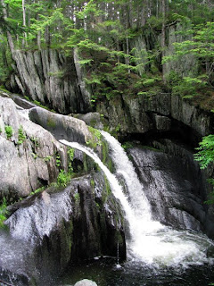 We passed through Gulf Hagas on this section. I nice loop hike round the "Grand Canyon" of Maine. We didn't have time to hike the entire loop, but did wander as far down as the first waterfall. It's a pretty area, and very popular with day hikers. We saw more people and familes today than we have since leaving Baxter State Park.
After our close call with the heat our old enemy, the rain, resurfaced. We had entire days of rain and cold. This time, rather than just being inconvenienced and wet, we were concerned about the large and frequent rivers that we have to cross before we reach Monson. The ford at Big Wilson stream concerned us most as it is a wide and fast flowing river. We crossed it in pouring rain, after a full day and two nights of pouring rain, but we were concerned that it would rise even higher and swifter if we waited another night to ford it. It turned out that it was waist deep on me, and took me a couple of attempts to cross it: My first was aborted about a third of the distance across because the current was too swift for me. My hiking pole was vibrating and hyperextended in the swift water. I backed out and finally made it across on the second attempt.
After all that, it was the second ford, at Thompson Brook that caused my worst problem of the day. It was just upstream of a 20 foot waterfall. The trail crosses this brook at a narrow point which is probably great at low water, but in high water it was a deep torrent. I decided to go upstream to a wider shallower point and successfully crossed there with water only up to my knees. After I had crossed, refastened my hip belt and sternum strap (always undone for fording in case I need to get out of the pack quickly) and was making my way back along the bank to the trail crossing, I slipped on the muddy bank and slid all the way down some slickrock totally out of control and back into the deep water. I managed to wedge myself into a rock before I was totally under water, but I and my pack were submerged up to my chest. I don't think l'd have had any chance to get myself and the pack out up the slickrock if I had been alone, in fact I had already unbuckled my straps and was prepared to jettison it if necessary. Fortunately though, Brian was almost across and managed to finish crossing, shuck his pack and scramble across the slickrock to my rescue. He provided the steady hand to hoist myself up on and boost me back up onto terra firma. This time when I gained the bank I bushwacked my way a couple of feet in from the edge before attempting to get back to the trail.
The last ford of this day was below the Little Wilson falls and this time was mercifully incident free. On the bank on the other side was a nice little campsite that we set up in for the night. We were glad to be through all the big fords, and evne more so when the rain continue heavily all night. The next morning we ascended the cliff next to Little Wilson Falls. It was an awesome sight with all the storm water flowing over the high falls.
And then we reached Monson; tired, dirty, wet and stinky, and very happy to be close to civilization. A very nice young man in a pickup stopped to pick us up at the trailhead. He was a volunteer fireman, and river rafting guide. He was on the way back from a river trip and it took him quite an effort to move all his gear around to make room for us and our packs. We were very grateful for the effort and the short ride. We arrived in Monson in time to pick up mail at the post office, get a nice greasy philly cheese steak sandwich to tide us over to dinner time, and a long hot shower. Ahhhh town!
View more photos in my Picasa album
It was challenging, gruelling, wet, muddy, buggy and overgrown. And it was lots of fun.
When we left White House Landing after another great breakfast our first stop was to pick up our next five days of food at Jo Mary road. It was dropped off their by Kathy Preble, and was very heavy. We are very glad we hadn't tried to carry all our food all the way. We saw our first moose today, a yearling that wasn't quite sure what to make of us. Then, despite the blue skies and sunshine we had had for most of the day, it ended in a downpour before we made it to Cooper Brook Falls.
Surprisingly the next day first day that I kept my feet dry. Especially as there was a ford crossing right before the shelter. We were lucky enough that we could pick a way across on rocks, though I had a very close call with some mud just after the crossing. At East Branch shelter there were only 2 hikers sleeping in it, Chris and Wes who have been hiking at the same pace as us. I decided to try shelter life. For the record, I slept OK but it was rather buggy.
To contiue with "fisrts" trend, I took my first potentially hike ending fall. It was just after summitting Whitecap Mtn. Going up was steep and hot, but the view from the top was extensive and impressive: we could see back all the way we had already come and forward to what was still to be hiked. On the way down I took a fall on the ravine like trail of microwave sized boulders. It could easily have ended my hike, or worse, but somehow I managed to flip over when I saw the jagged point of a rock coming straight at my face and I landed hard but on my pack and cushioned from any harm. Amazingly I didn't even get a scratch or a bruise. Talk about luck! The day after that we both attempted another first - Heatstroke. This time ascending Chairback mountain on another hot humid afternoon. Fortunately. just as we were both really starting to collapse we crossed a crystal clear cold mountain spring. We sat in the cool shade and filled up on cold fresh water and snacks. Just in the nick of time. The ascent up Chairback was like reliving Mt Katahdin, scrambling over huge boulders. I'm glad we were both cooled down and thinking strainght before we reached that.
 We passed through Gulf Hagas on this section. I nice loop hike round the "Grand Canyon" of Maine. We didn't have time to hike the entire loop, but did wander as far down as the first waterfall. It's a pretty area, and very popular with day hikers. We saw more people and familes today than we have since leaving Baxter State Park.
After our close call with the heat our old enemy, the rain, resurfaced. We had entire days of rain and cold. This time, rather than just being inconvenienced and wet, we were concerned about the large and frequent rivers that we have to cross before we reach Monson. The ford at Big Wilson stream concerned us most as it is a wide and fast flowing river. We crossed it in pouring rain, after a full day and two nights of pouring rain, but we were concerned that it would rise even higher and swifter if we waited another night to ford it. It turned out that it was waist deep on me, and took me a couple of attempts to cross it: My first was aborted about a third of the distance across because the current was too swift for me. My hiking pole was vibrating and hyperextended in the swift water. I backed out and finally made it across on the second attempt.
After all that, it was the second ford, at Thompson Brook that caused my worst problem of the day. It was just upstream of a 20 foot waterfall. The trail crosses this brook at a narrow point which is probably great at low water, but in high water it was a deep torrent. I decided to go upstream to a wider shallower point and successfully crossed there with water only up to my knees. After I had crossed, refastened my hip belt and sternum strap (always undone for fording in case I need to get out of the pack quickly) and was making my way back along the bank to the trail crossing, I slipped on the muddy bank and slid all the way down some slickrock totally out of control and back into the deep water. I managed to wedge myself into a rock before I was totally under water, but I and my pack were submerged up to my chest. I don't think l'd have had any chance to get myself and the pack out up the slickrock if I had been alone, in fact I had already unbuckled my straps and was prepared to jettison it if necessary. Fortunately though, Brian was almost across and managed to finish crossing, shuck his pack and scramble across the slickrock to my rescue. He provided the steady hand to hoist myself up on and boost me back up onto terra firma. This time when I gained the bank I bushwacked my way a couple of feet in from the edge before attempting to get back to the trail.
The last ford of this day was below the Little Wilson falls and this time was mercifully incident free. On the bank on the other side was a nice little campsite that we set up in for the night. We were glad to be through all the big fords, and evne more so when the rain continue heavily all night. The next morning we ascended the cliff next to Little Wilson Falls. It was an awesome sight with all the storm water flowing over the high falls.
And then we reached Monson; tired, dirty, wet and stinky, and very happy to be close to civilization. A very nice young man in a pickup stopped to pick us up at the trailhead. He was a volunteer fireman, and river rafting guide. He was on the way back from a river trip and it took him quite an effort to move all his gear around to make room for us and our packs. We were very grateful for the effort and the short ride. We arrived in Monson in time to pick up mail at the post office, get a nice greasy philly cheese steak sandwich to tide us over to dinner time, and a long hot shower. Ahhhh town!
View more photos in my Picasa album
Monday, June 23, 2008
off the grid -White House Landing

Our first three days in the 100 mile wilderness have been rainy, muddy, buggy and downright gruelling at times. This hike is much harder than I imagined that it would be. There is little opportunity to establish a rhythm to the hiking, and too much stepping over roots, rocks and thick black muddy bogs to consider it normal hiking. The swarms of mosquitoes that home in whenever you pause for anything are annoying. Fortunately we have Lemon Eucalyptus bug spray. This stuff, unlike deet , which just masks your scent from the bugs, this actually repels them. If there are multiple people around you can see instantly the effect it has on the bugs. It's become a race to see who can get the spray on first when a particularly voracious bug cloud drifts upon us.
The upside however is that the scenery is wonderful, and in the occasional moments when it's not pouring with rain the vistas are immense and beautiful. One such moment was the summit of Nesuntabunt mountain. We had arrived at the top in the late evening and had a last light glimpse og Mt Katahdin in the distance. It was enough of a thrill to see it at last that we decided to risk a night on the top of the mountain. It was an awesome night for it: cool, dry and clear. It was so quiet up there we could hear the slight breeze coming up the back side of the mountain and voices from the fishing camp below drifting over the lake. Later in the night we heard loons and coyotes calling. A perfect lullaby. Wakeup call was very early, 3:30am to be precise. It was defintely worth it for the view of the sun coming up, lighting up Mt Katahdin and the lake below us.
 We arrived yesterday afternoon here at White House Landing. It's an old Maine logging camp, and it's amazing. Not only is the location on Pemadumcock lake beautiful, but the camp is entirely off grid. No phone lines, no grid electric service or city water. The power is supplied by windmill and batteries, and a well spring provides clear fresh water. The owners provided a bunkroom, hot showers, and meals to hikers. They also have primitive laundry facilities, a tub, washboard and mangle, and they let us use their canoe to take a paddle out on the lake for the afternoon. The main food fare is a 1lb cheeseburger with all the trimmings. Yes, I actually ate a burger, the first time in who knows how long, and it contained a whole pound of meat! It was delicious, as was the home made brownie I ate as an appetiser. Today we've also enjoyed an all you can eat pancake breakfast and a home made pizza for lunch. We were the only guests here last night, but today more hikers have been trickling in since breakfast and now there is quitre a large group of SOBOs here.
View more photos in my Picasa album
Thursday, June 19, 2008
Abol Bridge, ME
Hiking in the rain is obviously going to be a theme on this trip. Today we made the short and relatively easy trip from Katahdin Stream Campground to Abol Bridge.
We actually didn't get rained on for the first couple of miles. We crossed our first non-bridged stream crossing. Maine has the "wildest" trail on the AT. The mountains generally do not have switchbacks, trails are not "groomed" and the majority of stream and river crossings are "au naturel" as in, they do not have bridges. Hikers have to get across these rivers by crossing in the water, or fording, them. Many of the crossings are over small streams, but there are also some sizeable rivers which must be crossed. Some of these can be dangerous to cross in high water, but in low water it may be possible to pick a route across using rocks and logs to traverse. Our fords today were mild compared to many of the fords we will have to make, but I was still nervous about them. It has been raining hard for several days, and I knew I'd probably be getting wet.
 The first crossing of the stream was actually dry, but pretty unstable. There was a log jam of fallen trees, about the size of my wrist, caught up on a couple of large rocks in midstream. Not an official bridge, but, if it held, at least a way to stay dry as I crossed. Lucky for me, it did!
The next crossing, to get us back off the island was a different matter. It had started raining hard shortly before the river, and it was cold too. The river water was ice cold. We watched two other hikers crossing as we arrived at the near bank. They were teenage boys, and the older had already crossed once with his pack and returned to the bank to collect his brother's backpack so the younger boy could cross unencumbered. He was shivering hard and they began crossing immediately before he chilled too much. The water was waist high on both boys until almost on the other bank when it suddenly reached mid chest. That got me a little worried.
Rather than cross immediatley, I decided to look upstream a little to see if there was an easier crossing. I walked maybe 1/10th of a mile upstream, seeing several places where you could probably get most of the way across on rocks, but nothing that would get me all the way. As the distance from the trail crossing increased, I also realised I would have difficulty getting back to it on the opposite bank, which was steep and heavily wooded. Returning to the trail crossing I wondered if maybe there was an easier possibility just downstream. Granted it was closer to where this stream joined an even larger river, however it looked like there may be a possible crossing, not dry but it looked shallower, and seemed to avoid the very deep hole near the opposite bank. That assumption turned out to be correct. I crossed safely, with the water between knee and thigh level, and only one tricky spot around some rocks and onto some deadfall at the opposite bank.
Later in the day we arrived at our last bastion of "civilization" for a while, the Abol Bridge campsite. It's not much to write about, but there is a small general store and coin operated hot showers. Arriving and setting up camp in pouring rain, nothing felt so good as 10 minutes worth of hot shower!
We never saw the two young boys again today, or any other hikers, but late this afternoon three other southbound (SOBO) AT hikers that we had met yesterday arrived: Chris, Wes and Bob.
View more photos in my Picasa album
We actually didn't get rained on for the first couple of miles. We crossed our first non-bridged stream crossing. Maine has the "wildest" trail on the AT. The mountains generally do not have switchbacks, trails are not "groomed" and the majority of stream and river crossings are "au naturel" as in, they do not have bridges. Hikers have to get across these rivers by crossing in the water, or fording, them. Many of the crossings are over small streams, but there are also some sizeable rivers which must be crossed. Some of these can be dangerous to cross in high water, but in low water it may be possible to pick a route across using rocks and logs to traverse. Our fords today were mild compared to many of the fords we will have to make, but I was still nervous about them. It has been raining hard for several days, and I knew I'd probably be getting wet.
 The first crossing of the stream was actually dry, but pretty unstable. There was a log jam of fallen trees, about the size of my wrist, caught up on a couple of large rocks in midstream. Not an official bridge, but, if it held, at least a way to stay dry as I crossed. Lucky for me, it did!
The next crossing, to get us back off the island was a different matter. It had started raining hard shortly before the river, and it was cold too. The river water was ice cold. We watched two other hikers crossing as we arrived at the near bank. They were teenage boys, and the older had already crossed once with his pack and returned to the bank to collect his brother's backpack so the younger boy could cross unencumbered. He was shivering hard and they began crossing immediately before he chilled too much. The water was waist high on both boys until almost on the other bank when it suddenly reached mid chest. That got me a little worried.
Rather than cross immediatley, I decided to look upstream a little to see if there was an easier crossing. I walked maybe 1/10th of a mile upstream, seeing several places where you could probably get most of the way across on rocks, but nothing that would get me all the way. As the distance from the trail crossing increased, I also realised I would have difficulty getting back to it on the opposite bank, which was steep and heavily wooded. Returning to the trail crossing I wondered if maybe there was an easier possibility just downstream. Granted it was closer to where this stream joined an even larger river, however it looked like there may be a possible crossing, not dry but it looked shallower, and seemed to avoid the very deep hole near the opposite bank. That assumption turned out to be correct. I crossed safely, with the water between knee and thigh level, and only one tricky spot around some rocks and onto some deadfall at the opposite bank.
Later in the day we arrived at our last bastion of "civilization" for a while, the Abol Bridge campsite. It's not much to write about, but there is a small general store and coin operated hot showers. Arriving and setting up camp in pouring rain, nothing felt so good as 10 minutes worth of hot shower!
We never saw the two young boys again today, or any other hikers, but late this afternoon three other southbound (SOBO) AT hikers that we had met yesterday arrived: Chris, Wes and Bob.
View more photos in my Picasa album
Wednesday, June 18, 2008
Baxter State Park, ME
 I summitted Mt Katahdin!
 It was quite a climb, which started out in the pouring rain. The main effect of the rain, other than making wet hikers, is that the trai, which is generally the lowest point in the immediate area, becomes a stream. In the case of the ascent of Mt Katahdin was steep mountain boulder filled stream.

By the time we reached the treeline the rain had slowed to a drizzly mist with occasional heavier outbursts. But the weather wasn't the problem at this stage,it was the rocks. The rocks that I had to climb up and over on this thing they call a trail up the mountain! They ranged from huge slabs of slickrock that had iron rungs to assist clambering up them, to steep cliffs of rough limestone, to boulders of all sizes.
 The mist obscured the mountain we were climbing, and mainly we could only see the next outcrop to be climbed. For several hours my utterances were mainly "there is no way they're expecting me to climb THAT" and "this has got to be the last one" and "we must be at the top after this", but there was always another steep pile of rocks waiting for me in the mist.
 Maybe it was a good thing that the mist was there. This mountain was high - over 4000 ft of elevation change from the campsite at the bottom to the summit, in a little over 5 miles of hiking. The top, when we got there, was cold, wet, misty, and totally worth the hike!
The sign at the summit is the official start of the Appalachian Trail for me. Apparently the five mile uphill slog doesn't even count in my mileage. We spent a short while on the summit, during which time the sky brightened for a few moments and it seemed to get warmer. Of course, as soon as I had removed a few outer clothing layers the mist turned to hail and I immediately bundled up again.
 As we descended down on the the plateau below the summit the sun did actually break through briefly. Even better, the hole in the cloud revealed the landscape below, far below us. It is very high up! Fortunately the cloud closed up again for the descent back down to the treeline. I think not being able to see around and below me during the descent was probably easier.
View more photos in my Picasa album
Monday, June 16, 2008
Millinocket, ME
We made it to Maine. It was kind of long and involved a taxi, two planes, a rental car, an overnight in Bangor, a bus, and a shutle provided by the Appalachian Trail Lodge in Millinocket. The most nerve racking part was hoping the boxes with our backpacks and their contents made the same flight cnnections as we did. It may be anal, but I actually stood in the window of both airports watching the baggage loading and unloading processes for the boxes. It worked. They made it.
The AT Lodge is great, a hiker bunkhouse which at this time of year caters mainly to hopeful southboud (SOBO) hikers headed for Katahdin. The lodge provides shuttles from the bus stop out on Interstate 95, and to Baxter State park for hikers. They owners also own a cafe in town, the AT Cafe, which provides a great breakfast and other meals. Our driver Paul handed us menus when we got in his truck then called in our dinner orders so our food was ready when we arrived. They provide a great service.
We spent today hunting down more bug protection. We have bug spray, but we met a hiker here who is absolutely covered in mosquito bites. Both of us had considered bug net clothing for the hike, but had rejected the idea as overkill. We've kind of changed our policy on that, and were fortunate to find suitable bug shirts, pants and headnets in the local hardware store. We aslo picked up the last few things we needed for the hike, and our fuel canisters which had been mailed ground to ourselves.
The adventure begins...
View more photos in my Picasa album
The AT Lodge is great, a hiker bunkhouse which at this time of year caters mainly to hopeful southboud (SOBO) hikers headed for Katahdin. The lodge provides shuttles from the bus stop out on Interstate 95, and to Baxter State park for hikers. They owners also own a cafe in town, the AT Cafe, which provides a great breakfast and other meals. Our driver Paul handed us menus when we got in his truck then called in our dinner orders so our food was ready when we arrived. They provide a great service.
We spent today hunting down more bug protection. We have bug spray, but we met a hiker here who is absolutely covered in mosquito bites. Both of us had considered bug net clothing for the hike, but had rejected the idea as overkill. We've kind of changed our policy on that, and were fortunate to find suitable bug shirts, pants and headnets in the local hardware store. We aslo picked up the last few things we needed for the hike, and our fuel canisters which had been mailed ground to ourselves.
The adventure begins...
View more photos in my Picasa album
Subscribe to:
Posts (Atom)