Thursday, January 24, 2008

Apalachicola National Forest

We made to to Apalachicola. This is a big milestone for me. When we drove up here a year or so ago for the Monkey Creek F-Troop project I remember thinking that it seemed like a long way from home and it would take forever to hike to here. It is, and it was!

The pines of the southern Apalachicola NF range from mature to young trees. Throw in a couple of burned out areas, and a very damp, dark mixed forest and you've got a very pleasant forest hike that emerged on the banks of the Sopchoppy River.

The Sopchoppy seemed to be flowing fairly fast. We sat for a while at lunchtime watching the bubbles flowing rapidly downstream and a couple of leaves running back upstream on a powerful eddy. The hike along the Sopchoppy ravine was great: Lots of bridges, and many great views of the river and the massive cypresses.

Soon we crossed Monkey Creek, a small creek which flows into the Sopchoppy just downstream of the bridge. The bridge is significant to us because we spent a week with Florida Trail’s F-Troop last year helping to build this 80’ bridge over the creek. It felt pretty good walking over the completed bridge, as we had had to leave before it was completed. Monkey Creek was flowing surprisingly low and slow compared to the Sopchoppy, which was good news for us, as it means that Bradwell Bay, which is drained by Monkey Creek, may be drier than we were expecting.

Nonetheless, we set out to hike the Bradwell Bay Wilderness with some trepidation. We are camped on the Sopchoppy river, which had risen several feet since we arrived a couple days before. Bradwell Bay is a 3 mile wilderness swamp area which is drained by Monkey creek, it’s only outlet. Despite seeing Monkey Creek in a fairly low flow, we are rather concerned that there may be a lot of water in the swamp, but that it just hasn’t started draining yet. As it turns out, our fears were unfounded. Six miles into the hike we crossed Monkey Creek easily. It was a mere trickle past the dreaded “hole” and we barely got the soles of our boots wet. After that the swamp was very dry, though rather overgrown and in need of some maintenance.

I was rather disappointed that the trail itself was in such overgrown condition. I understand that this is a very wet area usually, and therefore hard to maintain, but to my knowledge it has now been dry for several months, maybe historically dry, and I think it would have been a prime opportunity to get into this section to improve the trail conditions for when it becomes flooded again. It was a good hike, but I would have enjoyed the massive virgin tree stands more if I wasn't having to spend so much time looking for blazes, fending off branches and concentrating on footing.

View more photos in my Picasa album
Tuesday, January 22, 2008

St Marks Natioanl Wildlife Refuge

Another great hiking section, and this time again all in the woods, of St Mark’s National Wildlife refuge and away from traffic. It was good trail, and we saw a fair amount of wildlife, including deer, hogs, lots of alligators, and more birds than I can name.

Starting out at the beginning of St Marks we crossed paths with what was most likely a poacher. He was entirely non threatening, but was on the St Mark’s non hunting area, and was too quick with his “I’m lost, I think I’m on the wrong side of the boundary” for my suspicious nature. His gun was in it’s case though, and he didn’t have anything dead with him, and he appeared to go back in the direction we pointed him when we explained where the boundary was. Shortly after meeting him, we came across the first deer of the day, so I’m rather glad we saw him (or he saw us) when we did.

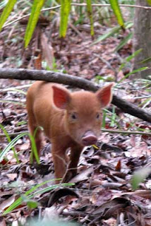
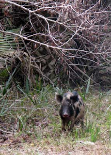
At one stage I was taking a water break and waiting for Ian to catch up to me, and four hogs calmly walked up the trail rooting around as they did. It took me a few minutes to come to my senses enough to grab the camera, and most had disappeared off into the brush by then, but I think I got a fairly decent picture of one of them.

At one point we were hiking along the levee separating the freshwater marshes from the saltwater flats of the Gulf of Mexico. the panorama view was of the west coast of the northern Florida peninsula to our east, and the south coast of the panhandle to our west. At a break in the marsh around an island we could see the blue water of the gulf in the distance. We had originally planned to camp overnight at the Ring Levee campsite, which is the closest to the gulf, on the outside of the main levee, but the weather was forecast to turn to torrential rain tonight and and below freezing temperatures after that for the next couple of days while a major winter storm system passes just to the north of us, so we took refuge inland again.

The forecast didn't lie. It did indeed turn very wet, then very cold. We started out all dressed in winter gear, and stayed that way. The biggest problem was that this was the day we would cross the St Mark’s river. The river is too deep and swift to ford, and there is no bridge. Usually hikers can hail a passing boat to carry them across, but of course on a cold day like today there was absolutely no traffic on the river! After 30 minutes we called a local resort for a shuttle across. They said it would take them 10 minutes to get someone out to us. It was actually almost an hour. That 90 minutes or so was spent sitting in the full blast of the wind roaring down the St Mark’s and in the shade of the trees that come all the way down to the water level. It was cold! I’m not complaining too loud though. We had originally planned to do this section the day before. It was absolutely pouring with rain all day, so we called a no hiking day. We’re told there was no traffic at all on the river yesterday, and even the resort would not have sent someone out in the rain! That wouldn’t have been a whole lot of fun.

After the cold wait, we had the boat driver drop us at the Riverside café, where a couple of cups of hot spiced cider and a bowl of chowder for lunch helped thaw me out. From the café the trail utilizes the St Mark’s paved multi-use rail trail for about 3 miles. This was the first rail line in Florida, from Tallahassee to Port Leon. It is now a trail for the 16 miles from St Marks to Tallahassee.

Interestingly, after not seeing another actual hiker on the trail, on this section, and not on the paved trail, we saw 4 hikers out of the day. One lady was out looking for orchids. She showed us the specific orchid she was here for. It’s not a native, and quite common in Florida, but is not listed in the orchid books as ever having been seen in this county, so needless to say was quite a find. They (there were four little stems) were beautiful, but absolutely tiny and growing smack in the middle of the dirt berm/trail/road. The one bloom that was apparently very pretty yesterday had been affected by last night’s hard frost and was laid down dying, but there were two additional new stems. Later, at Shepherd Spring we ran into two men out dayhiking. The spring was very pretty, and crystal clear. They shared their lunch spot with us and we spent a very enjoyable hour with them. Shortly after that we passed through an area called the Cathedral, a virgin stand of palms, which was quite impressive and beautiful with the sun streaming through the leaves.

On our last day in St Mark’s NWR we crossed some swamp with bog bridges. Real nice bridges, but I assume that either the lower steps had washed away at sometime in the past, or there has been major erosion around the bridge pilings, as some of them took a 3’ step up to the bridge surface. Luckily they were attainable with log assists, a minor tree clamber, and a reverse mount! At the end of the swamp, the forest suddenly ended at the salt marshes of the gulf. It was quite a contrast to stand on the edge of both.

The most surprising find of the day was a perfect undamaged sand dollar in the middle of the forest. The most incredible thing we saw on this section has to be the sunsets borne of the cold weather front. For two nights while we were out on the levees and marshes we saw the most spectalar sunsets. It made the cold worthwhile.

View more photos in my Picasa album

Thursday, January 17, 2008

San Pedro and Aucilla

Hooray. Hiking again! Of course, after 4 or 5 absolutely perfect hiking weather days when we weren't hiking, the last few actual hiking days have been crappy.

This section of hiking was fast paced, at least until we reached the Aucilla River. We left the Suwannee, and walked across San Pedro Bay WMA, about 50 miles of sand roads across an active logging and hunting area. We walk faster, but there is not so much to see.

The swansong for the Suwanne river was a neat little natural stone bridge with a tree growing over it right at our last trail point with the river. Moments after, in a green tree tunnel ahead of me I saw a doe who stood for several minutes while I got the camera out, and finally “huffed” and sprang off.

Sometime during our shuttling around the back roads to trailheads we saw a farmer’s field with literally hundreds of sandhill cranes seemingly in a line about half a mile long. We were not particularly close to them. I’m sure it would have created a chaotic scene of flight-taking if we had been. As it was we just enjoyed the silhouetted along the skyline. Other wildlife included a tiny ringneck snake, and lots of cat prints. Another day a military C130 flew over, then return a few minutes later escorted by a couple of helicopters preparing to mid air refuel, then again on a third pass over actually refueling.

Then we reached the Aucilla River, and to our pleasant surprise it actually had water in it. We had to stop for a coffee and play break at our first sight of in, and it had us wondering if during the entire course of this hike we will actually ever reach a pleasant swimmimg hole like this on an actual sunny warm day at a suitable time for a lunch or afternoon play stop. We saw an otter playing in the water and really enjoyed the walk along the steep banks until the river sank back below ground in a sink hole. After that we were back to walking in the woods along the course of the river now flowing mainly underground and making frequent appearances in sinkholes scattered along the trail. Each sinkhole had it’s own character: some appeared stagnant and lifeless at first, but closer inspection revealed almost crystal clear water, minnows and other water life, others were longer, like tree lined lakes, with colonies of ducks that scattered on approach. As the river progressed, the forest turned from swamp to pine forest, and finally the Aucilla reappeared above ground in a “normal” riverbed. At that point we turned away from the river and along more stone strewn trail, eventually emerging from the swamp and pine forest on a sand road, and highway 98.

During the brief roadwalk we stopped by JR’s Aucilla River store for snacks and refreshment and bumped into someone I had met at the recent F-Troop project at Three Lakes. Liz restated her previous invite to stop by at her place for laundry, showers, etc as we passed through this area. We still had miles to hike today so could not accept, but may take her up at the weekend.

View more photos in my Picasa album
Tuesday, January 1, 2008

Along the Suwannee River


What a great hike along the Suwannee River. It was marred only by a couple of damp and cool days, and by an ignorant or aggressive landowner who allowed his six large dogs to harass us while we walked the couple of hundred feet of trail at the bottom of his property. He was on his porch, as were 5 of the 6 dogs, as we approached. Rather than call back or secure his dogs, he just allowed or encouraged them to run down, surround and bark at us. I tried to ignore them and walk on, but the most aggressive, a pit bull was too close to comfort for Ian and had to be pepper sprayed.

We started out at the White Springs Nature and Heritage Tourism Center, Mainly becasue it was warm in there, and freezing outside, but once inside spent the time to look at all the exhibits and collect loads of brochures.

A couple of non river milestones on this leg were my fourth and final crossing of Interstate 75 (first crossing was way down south in Big Cypress, an additional twice on the western corridor) and Interstate 10 for the second time. We will have two additional croosings of I10 before we finish.

The hike along the river was a nice workout up and down the banks, along switchbacks, and steep and slippery ravines. One ravine we crossed, Swift creek was running with a good flow of clean clear water. It was interesting to see it mixing with the tannin colored Suwannee water at the confluence. On the bluff above Swift Creek was a perfect backpack campsite; just enough level packed sand for one tent, easy access to the clear stream, and a great view.


For an entire day we played leapfrog with a group of canoers on the Suwannee. They had to do all the twists and turns, which the trail mainly rounded off, but we got all the ups and downs in the gullies and ravines. I think they may have had the easier choice! I had a nice, but brief conversation with them from the old US129 highway bridge at the end of the day.

The terrain around Holton creek is very potholed, with creeks appearing and disappearing from predominantly algae filled pools right now. There is very little water flowing, and the Alapaha River is just a dried up sand riverbed. We saw a large doe, who we must have disturbed drinking from the only flowing water we saw all day, the source of Holton Creek. A little further down the trail was a young diamondback rattler who posed for pictures for a while.

On our first rainy day since Lake Okeechobee over a year ago we stumbled on a pack of wild hog piglets, without mama. They were very cute, rooting around and not really sure what to do with themselves. Later in the day we spoke to a kayaker who had see a large hog dead in the water. Probably our piglets' mother. I doubt they'll survive long alone.

In the Holton Creek WMA we came across a new remote campground put in by the Suwannee River Water Management District. It's part of the Suwannee Valley Canie Trail, and very nice: at least six large raised screened platforms for sleeping, a large covered pavilion, lots of picnic tables, grills and fire rings, and toilets and hot showers.

Two more rivers join the Suwannee during this section, the Alapaha, which was mainly just a sand riverbed with standing water, and the Withlacoochee, which flows into the Suwannee at Suwannee River State Park. We ate lunch at the confluence and watched the trains going by on the trestle over the river, then hiked upstream by the east bank of the Withlacoochee, and downstream again on the west bank almost back down to the confluence before breaking away from the rivers and passing through the old site of the town of Ellaville (no sign of it today). When we rejoined the Suwannee downstream of the confluence it's a much wider river, and seemed shallower, with several areas of shoals.

We’re headed for somewhere warm and a couple days off for now.

Happy New Year.

View more photos in my Picasa album