Thursday, February 28, 2008

Long straight road

Forty miles of road walking. Yuk!

It should have only been about half that much, but we doubled the road walk by a hard, but necessary for our safety decision. The final part of the Eglin East hike includes at least two river crossings that are at dangerously high levels and uncrossable, or requiring a road walk around. The recent heavy rains, or deluge as the locals are referring to it, have left several rivers in the area running in very high flood. We had another storm system on top of us bring heavy rain, high winds and cold temperatures for a couple of days. As hard as it was to voluntarily replace beautiful trail miles with more road walk, risking drowning or hypothermia from hiking in thigh high fast flowing cold water in cold temperatures were not on the agenda for this week. We are too close to finishing this hike to start taking health or life threatening risks. So the road walk it was.

Actually once we had made the decision and started hiking it wasn’t too bad a hike. Just long and straight, lots of traffic, and cold and windy weather. The forecasted storms actually passed more to the north of us, dumping their rain into the watersheds of the rivers we had feared. We crossed a couple of them, and were very glad with our decision: the rivers here are running high, wide and swift. One rather long bridge had the narrowest sidewalk I’ve ever attempted to walk on, made of concrete rough than coarse grain sandpaper, that resulted in a hole in each side pocket of my hiking skirt!

We passed through the town of Crestview on the second day, notable mainly for the local MacDonalds that was nicely positioned just in time for a fast food lunch. The next day we lucked out on lunch again, with hot meals at a convenience store in Holt. I guess there is some advantage to be had from road walking!

The only real wildlife on this long roadwalk, but we enjoyed watching a couple of hawks climbing on thermals then diving fast down to earth before climbing again, and I was hassled by a couple of problem loose pitbulls, one of which nearly got hit by a car as he finally backed off from me.

Tomorrow we go backin the woods. Yeh!!

View more photos in my Picasa album

Monday, February 25, 2008

Woods, Water and Munitions!!!

Off the roads and into the woods again. It felt good to be walking on trail.

We have hiked across the first part of Eglin AFB. Eglin used to be a State forest before it was reassigned to the military to use for munitions testion. We had to have a permit to hike across the base. Of course the thrail route stays away from any particularly sensitive areas, but we did have to sit through a video of how to identify unexploded munitions from bullets to bombs to missiles!

We found nothing unusual or unexploded, but did experience some new firsts for our FL Trail hike: First 17+ mile day (jointly anyway, I had had one longer last spring), first blue blaze high water route, and first headlamp hiking. The middle first was the reason for the other two. We set off knowing we had 15 miles to cover. The first couple of miles had lots of small streams that showed obvious signs of flooding due to the recent heavy rains, but were now merrily gurgling with crystal clear water and well within in their banks. There were several streams that were actually dry again, and very little standing water. When we reached the alternate high water route blue blazes we both agreed there seemed little cause to take it. Boy, were we ever wrong. A mile later, a slow, up and down the ravines and several blowdowns later, mile we came to the Alaqua Creek, a raging swollen torrent with an underwater plank bridge disappearing into the turmoil. Ther was no way we were crossing that! So we doubled back and took our first high water route of the hike, and adding 2 miles and more than an hour to our already long (for us) day.

Crossing the creek on the alternate road route we could see that the creek had indeed actually dropped from it’s former flood stage. It appears that even the road bridge was underwater within the past couple of days but the water had receded enough for us to continue dry, and most of all safe.

Joining back to the main trail we realized that we were now going to be short of time to complete the hike in daylight. There are very few options for bailing out of the Eglin base anyway, so we decided to continue, but pick up the pace a little to try to finish before dark. Of course, being in the forest, especially with somany creeks and swamps, there are always more photo opportunities, and we ultimately finished up the last mile or so of hiking by headlamp.


On the second day of hiking we still didn't spot any UXB's but did encounter an area of pungent smelling smoke. Afraid there was a fire we hurried to the next road crossing. On the way we heard heavy vehicles driving ahead which we assumed would be military fire trucks, but saw only civilian dump trucks. The smoke had cleared by then anyway, so we just hiked on.

But, did I mention it really was great to be back in the woods again?

View more photos in my Picasa album

Saturday, February 23, 2008

And the Road Goes On!

Impossible as it may seem, I dragged myself away from a warm sunny beach in Jamaica a couple of days ago, and we’re back hiking today. The hike to greet me home, all road walk. Apparently there was 5-7 inches of rainfall here in the past couple of days, and the drive back to Freeport yesterday was extremely wet. We noticed lots of standing water by the roadsides, so were not particularly looking forward to the hike: flooded roadside ditches give us no alternative other than to hike on the road shoulder, which is much more stressful and less relaxing than being able to be 10-15 ft off to the side.

Fortunately the first three miles into Freeport was very light traffic, so even the frequent on road walking was not too bad, then north of Freeport the roadside widened and flattened out, leaving lots of shallow damp areas, but not much to prevent us walking off road. Shortly before the intersection of the new US331 spur road and the old road we found a sand utility line maintenance road running parallel with the highway. We spent the majority of the afternoon walking it, and were very grateful for it. US331 is a very busy highway on a Saturday afternoon, and again has only narrow steep embankments to offer for an alternative to walking on the narrow road shoulder. On the few occasions the utility road became too overgrown or wet to hike we ventured out to the road and were always glad to be back off it as soon as possible.

On a side note, I passed fellow Florida Trail hiker T-Back hiking on the road walk between Blountstown and Econfina Creek yesterday as I drove back here.

View more photos in my Picasa album

Thursday, February 21, 2008

Jamaica, Mon!

Ahhhh, the beach.

I've spent the past five dasy lounging on a sunbed by beautiful turquoise water, under blue skies, sipping on fruity rum concoctions, and enjoying the sun. Except when it was raining!

The vacation was courtesy of good friend Mark, who invited me to join him at Firefly Cottages when his wife wasn't able to travel. That conversation went somthing like this:

M: Hey, I'm still going to Jamaica in a couple weeks. Want to come. The room's already paid for, you just have to get the flight.

J: Hmmm. Don't know. I'm supposed to be hiking along a long roadwalk stretch in the cold wind and rain that week.

M: OK. Just thought I'd ask.

J: OK. Give me 10 minutes to get some flights booked. I'll be there.

After the cold weather last week, and the drudgery of the roadwalk, I was ready for a week of just lounging in the sunshine. Mark had all these plans for active stuff like snorkelling and long beach walks. As if a hiker on a break from hiking really wants to walk ANYWHERE? I would have done it though. The walking at least.

Unfortunately I am a klutz. Having walked about a thousand miles of the FL Trail over roots, through mud, etc., without injury, I managed to bust that trend by tripping over a wheelchair in the airport when they called my boarding group for the flight. I didn't think it ws serious at teh time, just a couple of bloody grazed knees and rug burns. I even managed to get an ultra last minute upgrade to first class when I asked the flight attendant for some ice and it was obvious that I needed to sit with my legs up. (Might have to try that on again some time!) So I arrived in Montego Bay and hobbled out to the arrivals area to meet Mark all swollen and blooded! Sure he appreciated that.

So, I'm not sure what exactly I did to my right knee. The left is OK, but the right is still swollen and tender and doesn't really like having my weight on it. I did everything I could for it to rest it, which basically involved laying flat on my back with my legs up, resting and relaxing, for the entire vacation. I had to. My hike depends on it! Mark did his snorkelling and walking, and we did managed a day trip to Hedonism II for a change of scenery for me to sit in for a day. We both had a great vacation.

Tomorrow I'll drive back to north Florida and we'll see if the knee wants to hike.

Thursday, February 14, 2008

"Bigger Than a Bob, Ma'am!"

We're back on the road again. This time SR20 for a couple of days.

Despite SR20 being such a busy road the walk actually wasn’t too bad: for a lot of it's length there is a nice wide grassy area on either side of the road, with a fairly level walkable strip along the furthest point from the road. When this lucky level strip disappeared the walking was miserable. Either “one leg higher” hiking on the steep slope, or down in the the bottom of the roadside ditches which contained a couple of inches of standing rain water. When the road wasn’t too busy I hiked on the edge of the blacktop. That brings it's own discomfort, from stepping exactly the same place in your shoe on each step. A recipe for blisters. I'll admit I even junped a fence for a 5 or 6 mile of this stretch so I could walk on a dirt road on the ohter side of the fence.

The weather has been flaky, drizzly rain, follwed by a day of bitterly cold wind, then a cool and breezy but sunny day. I know most would say that mid 40's is not really cold, but when it is accompanied by a stiff breeze it’s tough on those of us that were hiking in the bare minimum of clothes 2 days ago!

Swwetest part of the last couple of days was Valentine's morning. My usual coffee in bed, supplied by Ian, my very capable Cabana Boy, was accompanied by a Valentine’s gift of chocolates and a Shrek card that burped when it was opened. You have to know Ian to truly understand this gesture, but how can you fault a day that starts out like that? I ate some of the candy for a breakfast appetizer, drank the coffee, and finally forced myself out of my nice warm bed to a frosty morning. The temperatures were below freezing until after 9 am, but fortunately for us we had plans to do some running around before starting our hike for the day. By the time we had driven to Eglin Air Force base to pick up the permits we will need for next weekends hike through there the temperature was up to a wonderful sunny 50 degrees.

Most notable point of this roadwalk was Ian passing his 1000 mile mark on the FL Trail. Go Ian. (Now catch up the 222 miles of Western Corridor you skipped!) We celebrated with a couple of sodas at that point. Weirdest event of the day, the week, and possibly even the entire hike? Around mid afternoon a guy pulled over in a really messy car, acting very shady, and claiming to be an off duty Sheriff’s Deputy and advised me that he had just seen a very large cat “too big to be a bob (bobcat)”. He seemed to want to drive me past where he had seen the "cat", but when I mentionned my hiking partner and turned to see how far back Ian was he got jumpy and took off in his car like a maniac, almost causing an accident in the process. Very weird. I waited for Ian to catch up to me, just to be cautious, but of course we saw neither the large cat or any sign of cat prints.

Hiking will resume in a week or so. I’m taking a week off to go sun myself on a beach in Jamaica.

View more photos in my Picasa album

Tuesday, February 12, 2008

Econfina

What a gorgeous couple of days to be off the roads again and hiking the very scenic Econfina Creek. We must have spent a couple of hours taking pictures at the Two Penny bridge ( basically a log with hand cables), and the Sweetwater Creek waterfall. Shortly after that we crossed the Fender bridge, which is in the process of being replaced by a new suspension bridge by the F-Troop (Fl Trail's maintenance crew). We had been warned that the old bridge might already be down by the time we arrived, and we might have to wade, or find an alternate way across the creek, so we were very glad to find the old bridge still intact, but we were rather cautious crossing it, not knowing if the dismantling process had already begun.

We celebrated Ian's birthday on our second day in Econfina. He doesn't like to make a big deal about his birthday, so I just picked up my pace a bit to be well in front of him, then wrote "Happy Birthday" in two foot high letters in the sand roads we crossed.

The trail winds through the woods along the creek, then along the side of a steep ravine before hiking a couple of miles through a pine forest. The last mile or so of the off road hike was through a logged and replanted area which had also had a recent fire. It was the first time we had come across an area like this with such new growth pines and we really enjoyed the hike across the high valley. The small trees were just finishing the grassy phase and becoming tree like and were very lush and green. Some had been affected by the fire and had half scorched brown needles and the other half green. The trail here is one of the few places we have hiked so far where you can see ahead and behind for a considerable distance.

View more photos in my Picasa album

Sunday, February 10, 2008

Planes, Trains and Automobiles

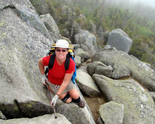
It's been a while since we had to do a long road walk, but we knew it would be coming back, and that we'd have a lot more of it from this point on. The road from where we exited the Appalachicola National Forest to Blountstown actually wasn't a bad walk starting out on the relatively lightly traveled CR12. We were surpreised to be stopped twice by local folks out driving that wanted to offer to help out with shuttles, resupply, laundry etc. I guess the must be used to bedraggled hikers emerging from the Forest after 80 something miles of no services and desperate for real food and a shower, etc. Lucky for us, with having the two cars to shuttle, we are in a better position than most. We did appreciate their offers though, and told them so, and gave them notice about the hikiers we know of that are behind us and might be in greater need of their services.

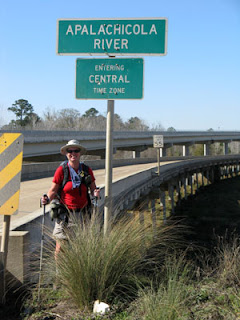
Bristol and it’s supply of convenience stores and restaurants was perfectly positioned for a lunch stop before we set out across the Apalachicola River bridge. The river is the time zone divider, so we walked into the Central zone here. The bridge is almost 2 mile long, and has a nice wide pedestrian walkway separated from the high speed traffic by a concrete divider. It was a fairly relaxing pleasant walk and I even took a short break in the middle of it, but I still made it to the other side before I'd set off!

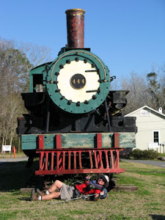
Right as we arrived at the edge of Blountstown a couple of Air Force jets flew over quite low, and following the road. My friend Marti works for the Chamber of Commerce here, and we were sure she had laid on the "fly by" to welcome us to town. It turns out she didn't actually do that, but she did meet us at the railway depot armed with a couple of ice cold sodas. That's even better.

Through Blountstown the trail is on the newly opened paved bike trail. I'd walked this several times this past summer during the inaugural hike/bike event for the opening of the rail trail, but I didn't bail out and make Ian hike it alone. After Blountstown is an entirely different beast: Roadwalk on a very busy two lane highway with only a 2 foot blacktop edge and little or no grass available to take refuge on, only water filled ditches. We walked close together and against traffic for safety, but it was really quite harrowing seeing how little attention and space drivers give pedestrians. The majority of the Saturday morning traffic appeared to be grey haired old ladies who had no idea what to do when they saw a hiker, except ignore them and look straight forward, or soccer moms in SUVs and talking on cell phones. Add to that a smattering of teenagers, trucks towing boats, etc and it amounted to a constant parade of high speed vehicles riding the white side line of the road. In three ahours of almost constatnt traffic I noticed 4 vehicles that actually pulled over the center line to give us a little space. They all got a wave of thanks, I almost got a stiff neck from shaking my head at the remainder.

The road was full of roadkill, including a deer, a fox, a rat, someone’s ex family Labrador pet, several cats, a raccoon and some unitendifiables. I’m just glad we got off the road without adding to the list. In addition to the roadkill, Ian found a wallet on the roadside. It looked like it had been lost fairly recently. It contained no cash, but someone’s license, credit cards, social security card, etc., and some nitro glycerin medication. Shortly after finding it we passed an older gentleman cutting grass, who looked about the same age as the woman on the DL. Ian asked him if he knew where the address was, and the man actually knew the lady, and promised to get the wallet to her that afternoon.

Fortunately it was only 8 miles before we turned off the busy highway onto quieter roads with a wider grassy area to give us more room to parallel the road. A couple of cars actually pulled over to ask what we were doing. Only one vehicle was aware there was a trail here. That road took us over some high (for Florida) hilly country and we had some quite extensive views over the hills and forests of north Florida for the past couple of days. Now we're at the Scott Rd trailhead for the Econfina WMA. We'll only be off the roads for a couple of days, but we'll take any real trail we can get.

View more photos in my Picasa album

Thursday, February 7, 2008

Apalachicola National Forest - Part 2


We returned to the trail at Bradwell Bay to find that we have pretty good timing. Returning to the exact spot we finished hiking a week or so ago, we found smoldering brush and signs stating that the trail behind us is closed for a scheduled burn. There was also a lot of roadside water that definitely had not been any here when we left a week ago. I guess there must have been substantial rain here during the week we took off.

The hike was a good mix of forest and swamp. We hiked along the ravines of the Ochlocknee River, stretches of forest, everything from newly planted pines to established forest, and along sandy forest roads in between.

We have based ourselves at a remote campground at Camel Lake and we're continuing through the forest in perfect weather, clear blue skies with an occasional puffy white cloud, abundant sunshine and mid 70 degrees. The not so distant memories of cold starts, wool sweaters, buffs and gators are just that, memories. This was weather for exposing skin to sunshine!

We did have one day in the middle of this section where the weather didn't quite cooperate. We woke to dire predictions of tornadoes, high winds and lightning for the afternoon, so we opted to cut our day short. We were a couple of miles short of our end point, in a very swampy area with a 2000 ft puncheon bridge and lots of various types of Pitcher plants. It appeared that pitcher plants must not be frost resistant, as there were many fallen and dried out. It must have been impressive in here before the freeze hit. We did see plenty of new young plants though. As we neared the end we started to hear thunder and increased the pace a little. One of us must have some good karma built up, because we made it back to the car dry, changed quickly into driving clothes, and before we even got pulled away the rain was pouring down and trees bending over almost double. That was close.

This was a really great several days of hiking. Hunting season is over, so we have the forest back to ourselves again. I enjoy the woods much more that way. I did have a couple of little misphaps: One potentially nasty little fall when I stepped on a wooden log step up onto a bog bridge. The log was slick and my foot shot out from under me and I ended up turtle style on my backpack. The other was when I outhiked myself on one sand road. I managed to miss a turn blaze off the sand road while day dreaming and hiked a good ¾ mile before realizing my error. Lucky for me, by the time I doubled back and caught up to Ian, he had managed to single-handedly clear about a half mile of trail that had been covered by impassable blowdowns. How is that for teamwork?

Great hike, but now we're headed for some roadwalking for a couple of days again.

View more photos in my Picasa album

Saturday, February 2, 2008

Slow Boats and Fast Cars

I took a couple of weeks off from hiking to spend some time with my friend Javier while he is in Florida on a business trip. After his meetings were over we spent a couple of days relaxing in Ocala National Forest. We visited Blue Springs to walk and watch the Manatees, then spent a day canoeing at Juniper Springs. I have run Juniper many times in a kayak, but paddling a heavy aluminum rental canoe is a whole different experience. Especially when the paddler in the rear thinks they are an outboard motor! We had a lot of laughs and great fun.

After a day of walking and visiting the Marjorie Kinnan Rawlings homestead I think Javi had had enough of the "real" Florida and was ready for something more fast paced. Unbelievably, we ended up at Daytona Raceway where I watched cars going round and round in circles for several hours.

Hiking will resume in a couple of days.