Sunday, November 26, 2006

Big O

The "Big O" is a nine day series of 9 to 14 mile day hikes that circumnavigates Lake Okeechobee, the second largest lake entirely within the US. The trail around the Lake is called the Lake Okeechobee Sceneic Trail (LOST). It is located on the top of the Herbert Hoover Dike which completely surrounds the lake and protects the local area from flooding during a hurricane. The Florida Trail utilizes the LOST. Florida Trail hikers have the choice of hiking the East or West side of the Lake. I decided I would do the complete circumnavigation of the Lake instead of choosing sides.

There is no shade on the trail, so it is preferable to hike it in cooler weather. While there is a good amount of birds and wildlife, the scenery is basically the same for 110 miles. I decided to hike the lake section with the Florida Trail group that hikes it annually during Thanksgiving week. Friend Ian also wanted to get this section out of the way so he will not have to tackle it in warmer weather during his thru hike.

View more photos in my Picasa album

Wednesday, November 15, 2006

Building Monkey Creek Bridge

Monkey Creek is in the Apalachicola National Forest. Florida Trail's F-Troop trail crew is rebuilding an 80' bridge that will take the trail over the creek replacing an old washed out bridge. They have called for volinteers to assist with the project, so I thought it would make a nice first time F-Troop volunteer week for me. A base camp has been set up a short distance from the work site. Some volunteers will spend the entire 10 days at the prtoject, others will spend the weekend, a couple of days, or travel in daily. Before the construction starts will be a Ropes and Rigging training starting early Saturday morning. It's a good 6 - 7 hour drive for me to get to the site, so I planned to arriving on Friday night, then camp for a week and leave the following Thursday or Friday.

The project started with a rigging training involving a presentation of what can be achieved without machinery, but utilizing human labor and rigging techniques, rigging terminology, equipment, etc. After learning some of the theories of using rigging to use limited muscle power, and maximum brain power to move objects larger than could be moved using strength alone. We had a demonstration of how many pounds of pull strength the average person has. It was about equal to body weight. To show how rigging can increase that pull strength, a full size truck was attached to a tree with a wire rope, rope pulleys, and anchors, then I pulled it several inches just by pulling the center of the rope.

The base camp was either 1/2 mile, or almost 2 miles walk through the forest from the bridge site, depending who you ask, and whether they guesstimated or actually measured with a GPS! It's a pleasant walk, and most walked it at least once. Additionally, the Forest Service had "improved" a dirt road into the site that was suitable for high clearance vehicles. There were enough trucks available to provide rides to and from the worksite daily.

Monkey Creek has an existing bridge crossing, but it was washed off its foundations during a high flow several years ago, and now sits at a precarious angle, wedged in a tree. Hikers are currently advised to wade the creek as long as the water is not high. The new bridge is 80' long, and will sit on top of the creek's banks, well clear of regular water levels, and about 1/4 mile downstream of the old bridge site. Part of the weeks work will involved dismantling the old bridge and rerouting the trail to the new crossing point.

The water level in the creek is currently very low. That's great news from the construction point of view, as we won't have to risk life and limb to struggle across the creek. Two large steps would easily get a hiker across the water, but rugged construction experts that we are, we placed a 12' 2 x 10 plank or two across the water to save us even having to get our boots wet! I have to admit, it did seem rather funny to me to be replacing this with an 80' bridge! However, construction was obviously planned for the time of year when water levels are lowest. I have not seen the creek in flood, and it does have fairly steep banks. I'm sure that at higher water levels there would be considerable risk to crossing due to the water depth.

The area of the creek is a pleasant gently flowing backwater, with still, clear, tannin colored pools lined by white sand, gnarled twisted cypress knees, and shady pine forest. Reflections of blue skies on the brown water, and the occasional mushrooms just completed the picture. It's a beatuiful spot, and would have been very serene if there were not 30 construction workers immediately overhead and around.

Serenity was not too far though. About 1/4 mile downstream of the bridge site Monkey Creek flows into the Sopchoppy River. The ten minute walk down to the confluence was a popular lunchtime activity. If anything, the Sopchoppy seemed even darker tannin stained than Monkey Creek, almost to a deep red tea. The river turns a 90 degree bend immediately before the confluence. The river level is low right now, giving access to the flat white sand edges of the river, below the steep 10' - 15' banks. This minature gorge is filled with the exposed roots and limbs of Cypress trees that are evidence of scouring when the water is higher.

About 1/4 mile upstream of the bridge site the trail crosses the creek at the site or the old bridge which was washed off it's support several years ago in a flood and has been wedged up against a tree since. A small crew spent a day dismantling the old bridge and relocating the used timbers up to the new bridge site. Some of the old material will be used temporarily during the construction process, some will be used for construction of a ramp up onto the new bridge, and the remainder will be removed at the end of the project. The Florida Trail will be re-routed to the new bridge location when it is completed.

At the construction site, on the first day, was organized chaos! The ground was strewn with piles of the bridge kit pieces that will eventually become the 80’ free spanning bridge. The pieces are made of a light-weight fiberglass composite material, precut and predrilled. Lightweight is a relative term, many of the pieces are large and/or long, and flexible. They require several bodies to move them. Our job is to take the piles of pieces, the instructions, and a couple of boxes of bolts and joints and make a bridge out of it all.

The plan was: Assemble the two 80' side trusses first, and utilize the rigging training to hoist each side truss over the river with a highline system, set them into place onto the abutments that have already been built by the trail crew, then add the extra side supports and the foot tread between. Sounds easy enough!

Except no-one realy knew what they were doing, or supposed to be doing. We swarmed the truss pieces, grabbing uprights, joints, bolts, washer and nuts and began putting everything together. Everyone was anxious to do something, and the way we were working you'd think we thought we could get it built in a day. As the afternoon wore on, those smart enough to take a break sat on the abutment on the far side of the creek, looking longingly like they were expecting a bridge to come over any moment.

As the bulk of the crew worked on the bridge pieces, work was also progressing on the other element of the construction: Creating a rigging system to move the partially completed 80' long, heavy but very flexible trusses down the bank and across the creek. An essential part of that system is the spar, a tall strong pole which will bear the weight of the bridge. For this job, two spars, one on each side of the creek, and a sky line strung between. Suitable tall straight pine trees are identified, cut down, branches removed, and then the bark is shaved to allow the tree to be checked for cracks, etc, and to make a smoother surface for the straps that will hold winches, cables, etc. The end product looks like a telphone pole. A hole is then dug at the location the spar will be raised, and ropes, cables, and winches used to lift it into place.

Meanwhile, the piles of bridge pieces dwindle as the side trusses take shape. First one side, then the other, the kit is bolted together, tightened, torqued, jacked up and cambered. Finally we had two complete trusses ready to move. The trusses are temporarily supported upright with braces and ropes. The permanent side supports will not be added until after the bridge is in place. The 80' trusses are solid and stable while they are supported upright, but flex like a wet noodle when moved unsupported. An additional issue that was not anticipated, is that the uprights of the bridge extend about 6" below the lower support beam. This means that the truss will not be able to slide along the ground, but will have to be supported so the uprights do not dig into the ground, then moved along on roller logs until the truss is far enough forward along the sky line to be lifted completely off the ground.

A final check is made of the spar poles, guy lines checked and tightened, and we're ready to lift the bridge. This is the most complex part of the construction, and the most dangerous. Once the winch is tightened and bearing the weight of part, and then all of the truss, care must be taken at each of the wire ropes. They will all be under differing stress depending on where the weight is placed at any given moment. We are all given constant safety briefings and warnings. People are stationed at each pole and guy wire, and others are positioned to brace the bridge with ropes to prevent lateral movement as the bridge moves forward. ...and we're off! At first the leading edge is lifted off the ground, and the rear is rolled forward inches or feet at a time. Once the front half of the first truss is "flying". With a brakeman in the rear to prevent the entire truss from flying down the line out of control, the rear is also lifted up on the skyline and the entire truss is airborne. A crew on the far side pulls, the brakeman releases slowly, and the truss inches it's way to the other side of the creek.

As the truss progressed down into the creek, those 6' lower extensions of the uprights became an issue again, and additional bracing, log rolling, and a little manual jacking and lifting was needed to complete the journey over the creek. But the pulling contined, and the creek was soon crossed, and both ends of the truss steered to their abutments. The first truss was positioned, bolted, and braced into position.

Now the process just has to be repeated for the second truss. Before starting the second movement the crew practiced on the winches and ropes by moving the wooden footing planks cross the creek on the skyline. Unfortunately, the great weather we have had so far for construction failed us at this stage. Just as the second truss was attached to the skyline and began it's ariel journey a storm was approaching. Severe weather was reported west of us. High winds and tornadoes were possible. Debris and small branches were already falling from the trees above us, and the Forest Service declared the worksite was to be cleared. We secured the half moved truss as tight as possible, cleared up the worksite to remove or secure and potentail flying objects, and returned to camp.

And that was where my first F-Troop project had to end. I was supposed to leave the next day anyway, but with the threat of severe weather, the sleepless night that would ensue trying to sleep in a windblown tent, and especially the idea of having to pack up a wet tent in the morning, I decided to pack up and head for home tonight instead. I would have loved to stay another day, especially if it meant seeing the bridge completed, but I have a hiking trip planned starting early Saturday morning. I doubt at this stage that I would see the bridge completed before Friday afternoon, which would be the very latest I could leave to do the 400 mile drive down to the start point, and get my laundry done too.

But that's OK. I now have an excuse to return soon to this trail section to hike it and cross the newly completed bridge myself. I won't have the experience or the pictures of the final stages of completion, but I know which bolts I put in myself, and I'll be able to come visit them and still feel the accomplishment of being a small part of the construction.

View more photos in my Picasa album

Monday, October 23, 2006

Grand Canyon Raft Trip

This trip is a 16 day Geology focused raft trip. It is double the length in days of my previous trips, travelling 226 miles of the Canyon by man (and woman) powered oar boats rather than the motorized rafts I have previously taken. As with previous trips, there are lots of photos here of river, rocks, and sky. I'm not even going to attempt to journalize the trip, nor keep the pictures in any chronological order, but group a few of my favorites by type, and add some descriptions.

We started out the trip on a beautiful, sunny, if a little cool, early October morning. At the early pickup in Flagstaff there was a light frost on the ground, so we were all rather relieved to reach the lower elevation of Lees Ferry and warmer temperatures. There had been rain storms and flash flooding in this area over the past several days, but we started out into the rising Marble Canyon in sunshine, and the clear blue green water coming from Glen Canyon Dam. However, that was the last blue water we saw! Within the first mile, the muddy flow of the Paria River joined the Colorado.

The trip transportation was seven 18' passenger oar rafts, one dory, and one gear raft. Our crew was very experienced, and included Trip Leader Brian, who has over 300 canyon trips, Bill driving the Dory, part owner of the company, but would never own up to how many trips, Gil driving the baggage boat, two Ericka's (actually one with a C, and one with a K), Robbie, Walt, Tom, and Trey, who was the second boatman on my first motorized trip back in 2004 (so I blame him for a part of this addiction!). As well as being great boatman, they were also good cooks, and displayed other musical and artistic talents. An awesome bunch. In addition to the crew was "work along", Rich, and Ross in an inflatable kayak, who hiked out at Phantom Ranch. The trip was led by Geologist Ivo Lucchita, and an additional 24 passsengers. It was a large group, but never really felt that way as we were spread out over the 9 boats. This was a great group of folks to travel with.

Mud played a big part in the trip. It's hard to imagine just how much, unless you were there, slipping and sliding, and gingerly trying to hop from rock to rock without getting sucked into it. In general there were several inches of slippery slimy silt covering the more solid base sand at the water's edge. My shoes were sucked off my feet several times while embarking/disembarking, collecting water, etc. Fortunately I was able to recover them, and a half pound of sticky red brown goo, each time. I actually managed to never slip and fall all the way down into the mud, confining myself just to several slides, but many did end up down in it.

The mud and sand gets in everything, and it was futile trying to wash it out during the trip. The river water we used for washing was the same muddy brown concoction that was making everything muddy in the first place. By the time we returned to Flagstaff my clothes bag was probably a pound or so heavier with it. The first hot water laundry run through the washing mahine just spread the mud around in orange splotches, several runs through later, there is still sand in the washing machine and dryer afterwards. I'm sure eventually it will wash out.

We saw only a couple of Big Horn sheep, but a variety of other wildlife. There were several Blue Herons (or one that followed us all the way), some Mule Deer, a RoadRunner, and a wild Turkey. I missed the picture of the road runner and turkey. We even had a small bird hitch a ride on an oar as we approached Duebendorf rapid. Boatman Tom was reluctant to dip the oar and dislodge the bird, but fortunately for us, it decided to fly off before the critical moment when steering was required.

As mentioned, after the first mile the river was brown. Actual hues ranged from slightly muddy, through chocolate milk, to deep red. Beautiful, but messy.


And then there were the rapids. They look so much more violent in brown! Every trip deserves a good Lava story, so here is ours. After 170 miles of river, we all think we are getting good at this rafting stuff: No-one had involuntarily entered the water yet, and apart from Trey's close up inspection of the Muav limestone outcrop early in the trip, Erica's little detour round the left side of Bedrock, and a couple of other little bumps and scrapes, we have had no mishaps. But you can't underestimate Lava Falls. So the boats all stop and scout the best route. The water is apparently at about 12k cfs (cubic feet per second) and as at Crystal Rapid, "it's a little crunchy", there is no really great obvious run. Eventually though, the boatman are reasonably happy with the run they have picked - all are going right. Us passengers are once again given the "sit down, shut up, hang on, prepare to bail" speach, and we're ready to run. Our boat has Walt driving, and three passengers up front to put the weight up there to help us punch through the waves: Joe, Genie, and Shan. I'm safely ensconced in the back, with instructions not to fly out, but if I do, try to miss hitting the oarsman and other passengers on the way out!

So the run is lined up, and we're sucked rapidly into the melee. Suddenly there is this towering wall of V wave hanging above us, and coming our way. Everyone ducks (it's reflexive) and we when come back out I look up. I'm still hanging on, and still in the boat. Unfortunately Walt (remember him, he's the one supposed to be getting us out of this alive) is gone! In my own words "Oh shit! We lost our rower!" Now despite the fact that no-one up front is really sure what a "rower" is, (maybe I could have said "boatman", "captain", "oarsman", or something more descriptive), they got the message anyway. They all turn around and also discover that we're missing something quite crucial. So the next 10 seconds are a chaotic panic: Joe went to jump in the driver's seat, and at the same time saw Walt hanging on the side of the boat and attempted to pull him in. The waves are still crashing over us, and now Joe is down on the low side of the raft pulling weight, when what we should be doing is high siding into the wave to prevent us from flipping. The upper oar is waving around dangerously. I'm pretty darn useless in any way, cause I'm hanging on in the back, out of reach, but also out of the way of the flapping oar. Shan is yelling "HI-side" and "grab the oar", and Genie is apparently feeling as shell shocked and useless as I am. I think I managed the high side when it was yelled. We didn't flip anyway.

Joe and Shan finally haul Walt back in the boat, but our left oar is jammed in the oarlock and useless. During the attempt to free it, Joe takes a serious oar crack to the jaw, spurring the next great quote of the day "Dude, I think you just broke my jaw.". Fortunately, we drifted helplessly but harmlessly out of the way of the holes, the waves, and the rocks. The oar was recovered, and with a few strokes we washed out at the bottom of Lava. Joe's jaw was not broken, but nicely bruised, and Walt lost only a flip flop and suffered only a jarred back. After a brief "Yee-Ha" yell at the bottom, with adrenaline running strong, and needless to say, a fair amount of water in the boat, we were issued the command to "BAIL". By the time we could come up for air almost all the boats were through. They all seemed to get pretty good rides, and apparently the passengers in the front Dory seats hardly even got splashed. Go figure!

At Nankoweap, one of my favorite places in the Canyon because it is so photogenic, I skipped out on the afternoon group hike up to Granaries for some sun worshipping on a small beach, but hiked up alone later in the evening hoping for some photos without people in. Unfortunately for me, I was caught and passed by another lone hiker from a private group camped in Lower Nankoweap. His name was Gabriel, and by the time I finally made it to the Granaries he was sitting drawing. I didn't disturb him. I guess I'll have to go back again to get my peopleless photos!

Did I mention the rain? We had a couple of cold and wet rainy days in the first week or the trip. Now it may seem strange to even have to mention cold and wet on a rafting trip. After all, the river is always cold, and you know and expect you'll get wet in the rapids! So why even mention it? Because it rained the day we traversed the Upper Granite Gorge, from Hance Rapid to Phantom Ranch. The Canyon in this area is hard steep rock, and when it rains, red water pours down the black gorge rocks in temporary waterfalls. It is incredibly beautiful watching and hearing this canyon erosion at work. Despite being cold and wet, we were loving it!

Even on the days it didn't rain on us, the sky was sometimes quite threatening or pretty with storm clouds at night. All the creeks running from the north side of the gorge were flowing with deep red water, and as we passed by the bottom of Clear Creek a wall of rocks, tree limbs, mud and debris flashed out of the side canyon.
As the rain eased off after lunch we arrived at Phantom Ranch. Several of us made a quick trip up to the Canteen. Bright Angel Creek was flooding vigorously and dramatically red (unfortunately I had left the camera on the raft). The foot trail to the Ranch was a muddy slosh of rainwater and mule dung. After completing the postcard and phone call chores, I hurried back down the trail, scaring up a wild Turkey as I did so. I think it interpreted my quickened pace as a chase. After running down the trail in front of me for a while, it turned to make a stand, then ran at me with feathers flapping. I'm very glad to have been the last to leave, there was no-one else around to have caught in glorious color the battle of a rock hopping, dung avoiding, bedraggled woman defending herself against a flapping turkey while determinedly protecting the slightly drier outer clothes in one hand and a lidless cup of hot Earl Grey in other!

We spent two nights at Bass Camp, and hiked to the old Bass site on the day in between. The camp was a major Grand Canyon tourist site in the past. Tourists would hike down from the South rim, be carried over the river in a cable car, then hike into and stay at Bass Camp. Old metal and glass artifacts from the tourist heyday are displayed under an overhang at the site.

Aside from the impromptu red on black waterfall display in the Upper Gorge, we did not get a chance to see as many waterfalls on this trip as I had in the past. Slot Canyons are not a great place to play when it is stormy! But after the runoff had calmed down, and the creeks returned to clear babbling streams we managed to squeeze in a few permanent falls.

Around the middle of the trip, on a sunny day, but in a shaded and cold part of the canyon we stopped at the Ledges for lunch. The Ledges was in the sun, and there was a small but clear spring flowing over the edge of the canyon above us, dropping in steps down to the edge of the river below. The final drop was directly onto the sand (and mud) about 3 feet from the river's edge. By standing on a rock it wasn't even too muddy on the feet. If this had been an overnight spot it would have made a perfect shower of clean and cool (but not as cold as the river) water, and there would have been a line of all the females on the trip waiting to wash their hair. Probably most of the men too. I don't think anyone else saw it, and I didn't have any soap handy, but I managed a quick refreshing soapless shower in it anyway.

All In all, an awesome trip. When can I go back?

View more photos in my Picasa album

Sunday, September 24, 2006

Withlacoochee State Trail

Spent the weekend on the Withlacoochee State Trail, a paved bicycle trail that the Florida Trail shares for about 30 miles.

It's an old rail trail, so fairly straight, and gently graded up and down through this hilly area. I forgot the camera, so no pictures. Did see two turkeys, one peahen, one deer, and one silver fox, plus lots of squirrels. The trail was very busy with bicycles on Saturday morning and I spent a nice rest break at a pagoda in Floral city talking to some ex-Brits from a local cycling club. As the day started warming up though, the cyclists diminished and only us crazies were out!

Spent the night at Fort Cooper SP primitive camping area, which I shared with a Frat party. They were a little noisy late into the night, but other than that it was a good night.

The trail parrallels US41 for a lot of it's length, and there are plenty of businesses to stop by in for sodas, icecream, snacks etc., so I'm sure I didn't lose much weight this weekend!

I was hoping to make it all the way to the end of the bike trail at Gulf Jct on Sunday, but as the day started to heat up I changed plans and wimped out at Holder. I've been spending too much hiking time this summer hanging out where there is cool water, kayaking etc., and don't have the stamina for this hot blacktop stuff. Roll on cool weather!

View more photos in my Picasa album

Saturday, August 19, 2006

Orlando Wetlands Park

Nice trail round the water impoundment ponds. Saw lots of birds and a couple of gators, then ran for our lives back to the car when we saw a very large thunderstorm coming at us.

View photos in my Picasa album

Saturday, June 3, 2006

Northern Arizona trip

North Rim
My intended destination was Point Imperial, but that plan was cut short when the Park Service closed the road due to very high winds and falling trees. I spent some time at the North Rim viewpoints (carefully hanging on) instead. As my trip to Point Imperial had been cut short I had some time to wander around at Lee's Ferry where I was camped.

The timing of this trip is to attend a Grand Canyon Field Institute Photography workshop. The first hike was into Cathedral Wash for the afternoon where we all took some basic pictures to be critiqued later that evening. Stupid me fell on a rock during this hike, severely curtailing my activities for the remainder of the week. By the time we returned to the Marble Canyon Lodge my foot was bruised, swollen, and extremely painful. I stopped at the gas station to buy ice, then attempted to sleep that night in the car with my foot in a cooler. Yeah, that was comfortable!

The next day's hike was into Buckskin Gulch. I wasn't even sure if I could make it, but I had wanted to do this hike for so long that I just had to try. I used my tripod more as a crutch than a base for the camera, and I didn't get near as far down the canyon as everyone else, but I did get some decent pictures, and learned a lot about lighting techniques, which would be very useful later in the trip.

The next day I was a lot more mobile again, enough so that I led the charge up our next destination, Yellow Mountain. This location was a lot of fun for me: we were out int he sunshine, in terrain that was totally new to me and unique. I loved it. I have to add this to my bucket list of places to hike more and explore. It's an area of eroded cross bedded sandstones with limestone fins that were originally casued by higher rock layers leached down through the sandstone and depositing limestone in the cracks between sandstone blocks. As the sandstone has eroded the harder limestone erodes more slowly and leaves angular fins protruding. The fins are very fragile, requiring careful footing to prevent breakage, but they make for some interesting photographs. The mainly areas light colored rock in this area is very stained by mineral desposits leaching through the existing rock, or from layers that have since eroded away, leaving interesting patches of reds and yellows.

The news about the last day of the photo class was very disappointing to me. I was hoping to visit one of the Coyote Buttes sites, or another dramatic area such as yesterday. When I found out the plan was to visit a stream loction to photograph trees I decided to abandon the remainder of the seminar and go my own way for the next couple of days. It was too late to get my own permit for Coyote Buttes so I decided to visit a couple of nearby areas that I'd wanted to visit.

Lower Antelope Canyon is a very narrow sinuous slot canyon of sandstone. The Navajo guide led us into the slot by sitting on the edge of a crack int he sandstone and stepping down into the narrow entrance. The canyon is very quite narrow in places and has some fairly steep natural drops which have metal steps to assist getting down into the depths of the canyon. The entire 1/2 mile length is a wonderful twisted experience of wind and water eroded sandstone. Most of the sandstone is smoothly weathered, but the are occasional stone embedded layers that add texture in the wall patterns. The footing is sometime a level sandy layer, but occasionally the slot walls slope all the way down to the floor, requiring careful footing. The Lower Canyon does not seem as popular as the Upper Canyon, but is uniquely different, quieter, and definitely worth a visit at any time of day. In 1997, eleven tourists were drowned during a flash flood in Lower Antelope Canyon. Obviously, the canyon is now closed during any chance of rain or flood.

Upper Antelope Canyon is wider at the bottom than the lower canyon, but the very narrow top allows light to shine directly into the canyon only in a few small places, and only when the sun is directly overhead during the middle of the day. This causes shafts or beams of intense light in the very dark canyon. Breezes from above cause sand and dust to filter down through the cracks enhancing the shafts. The canyon is beautiful, has a much more level and wider floor than Lower Antelope canyon, and is very different. It is extremely busy in the canyon during the 2 hours of most intense lighting, and very difficult to get unobstructed photographs, but a beautiful place, and definitely worth a visit.

Next, I knew there was a place somewhere on the Colorado Rim somewhere in the 15 miles between Glen Canyon Dam and Lees Ferry where there was an overlook of Horseshoe Bend, so I set out to find it, starting at Glen Canyon Dam and working my way downriver. I eventually found a trailhead with a couple of miles hike to the overlook, again well worth it.

Next day I visited Walnut Canyon to see the Sinagua Cliff Dwellings. I did not find these neraly as dramatic as the ruins at Sierra Ancha I had seen last year. I also visited the South Rim of the Grand Canyon, but decided to forego the South Rim village as I'd already been there, and stopped at Desert View WatchTower instead. I enjoyed the river views available here that you don't get at the Village, and particuarly being able to look down on the wide beach at Furnace Flats where I'd slept on a rafting trip.

Last stop was at Coal Mine Canyon. It is like a miniature Bryce Canyon. I would have loved to hike down into the canyon, but the canyon is remote, and there were no other vehicles around at the parking area so it seemed prudent not to venture down alone. I satisfied myself with pictures from the rim.

View more photos in my Picasa album

Sunday, May 7, 2006

Rodman Dam

It was a hot, humid, sticky night, and the attempts to get into the breeze didn't work! We were up fairly early in the morning, it had been a fairly restless night anyway, due to the heat, and once again we knew that the southbound hiking group would be out much earlier than we could possibly manage. They stay at civilized campgrounds, and don't have to pack up camp and load up backpacks before starting out in the morning. And they get up much earlier! We will get a chance to experience their style of hiking tomorrow as we will be shuttling up to their campground today after our hike, camping with them ,and shuttling back to todays end point to hike with them tomorrow. Today is Jack Hailman's 70th birthday and he is having a birthday dinner celebration which we don't want to miss out on. Deb Blick of the Florida Trail Association is GPS'ing a section of the trail from Lake Delancy campground this morning, and has agreed to wait for us at the trail crossing and will shuttle us to Rodman campground where the main group of day hikers will be camped.
Once again, I met up with the lead hikers very shortly after getting started out. I didn't stop for long, as I knew I'd be seeing them and have an opportunity to socialize tonight. At Grassy Pond, I took the blue blaze into the now abandoned campsite for a look around. When I returned to the trail I had no idea if Ian was now still behind me, or up in front. The morning air was already very humid, and even the early sunshine beginning to feel hot. The trail here is a “tunnel” between scrub and brush walls about 12’ high on both sides through pine forest. Visibility is mostly limited to straight ahead, and restricted by twists and turns of the trail. I was looking for a fallen tree in the shade for a suitable place for a quick water break, when I disturbed an animal that was very close, or possibly even on the trail. There was a bend in the trail at that point, and it was very shaded, but the noise receding off to the east was of a large animal, very unlike the bounding sound of a startled deer, more of a crashing, thunderous stomp. My obvious thought was “Bear”. I stopped, peered into the dense understorey, hoping to at least glimpse the famous “bear butt disappearing into the woods”, but saw nothing, no sign at all. Whatever it was had clearly retreated quite far off, but I decided to continue on a little way before I took my break. Just in case. After a fairly brisk quarter mile I decided I had put enough distance between me and my “probably a bear” to take a break, and came around a large bush to a widening of the trail where an old and apparently non-maintained trail crossed. There was no log to sit on, but the less dense cross trail allowed a little more of the cooling breeze to flow down to ground level. Removing my pack, I perched on the pack on the west side of the crossing. Ten minutes or so later, I reached around me to re-secure to the water bottle. While looking down, I heard movement coming up the trail behind the large bush. I couldn’t see round the bush, but made the natural assumption it was Ian. Surprise! Bear! Head on, on all fours, and about 3 feet tall at the withers, with a blue collar and radio transmitter. He saw me at the same time I saw him. It was a split second encounter. We were both as surprised as the other. He crashed off again to the east, I picked up and hastily shouldered the pack.

I remember thinking several things at once: “Bear!”, “That’s not Ian - Run”, “Where’s my camera?”, “Forget the water bottle – Run”, “Wish I’d had my camera ready for that”, “Run”, “Wow, I should warn Ian there’s bear”. I hastily scrawled the word “BEAR” in 12 inch high letters in the sand with my hiking pole, and set off up the trail at a fast pace. In my hurry, with my pack not properly balanced, and trying to look behind while making forward progress, I stumbled into the trailside brush, narrowly missed poking my eye out on protruding branch, and wrenching my right hamstring. After limping along a little further I came to a fallen tree at just the right height, angle, and position to take the weight of the pack while I readjusted it, and check out the minor damage, while still having a reasonable view back down the trail. I had just readjusted the backpack and was bending down to massage the back of my right thigh when I caught a glimpse of something black and moving on the shaded trail behind me. I ignored the 40lbs on my back, my straining hamstring, and my heart pounding. I ran. I think I ran for about half a mile before I reach the junction a road and ATV dirt trail, and the terrain changed from dense understoried pine to sparse/clear cut open pine. I collapsed on the grass by the road. With a clear view of open space around me, I grabbed my full 2 liter water bladder from the pack, almost drained it, then lay sprawled and cooling, heart gradually slowing, in the shade. Distance, and drop in adrenaline increases rationality. By now I was pretty sure the bear was probably just ambling along the trail minding his own business, as scared of me as I was of him. I may or may not have seen him reappear at the log, it could have just been a moving dense shadow. All I heard now were ATV motors in the distance, coming closer, headed in my direction. Ian caught up to me at my next break, around 10am as we had discussed. He had not seen any sign of the bear, but had seen my sign in the sand. As a classic example of how men think differently to women. I wrote “BEAR”, he read “BEER” and spent a few moments looking round the trail crossing for a cooler of cold ones! I’m just glad there wasn’t a hungry bear waiting in the brush for an unsuspecting, beer hunting hiker! As we approached Lake Delancy the trail enters an area of old clay pits, making it very reminiscent of the "trenches" in the beech woods near where I grew up. It was a little hilly, very pretty and would have been a pleasant place to hang out for while. Unfortunately, my wrenched hamstring was starting to bother me, as I changed my foot angle to bear my weight going downhill on the slippery oak leaf covered slope, I pulled the muscle again. At the same time, the revenge of last night's reheated prefrozen sandwich also made it's presence known. I was not a happer backpacker for a few minutes. Ian was ahead of me at this point, and must have been concerned that I hadn't caught up to him, as he kept calling down the trail to see if I was OK, but I finally caught up when he promised it was only another 1/4 mile. He lied! We saw an old blue blaze, but only a few steps down the unused trail made us think the trail marking was wrong. We turned back to the main trail and continued north. This area has ATV trails running everywhere. Thankfully, some of these have been blocked and are starting to recover from the "sandy pit" stage and start to look more like hiking trails. A little way down the trail was one of these recovering trails, and I could see the campground road at the end of it. Thinking that if the blue trail we saw was actually correct, we should go down to the road to look for Deb's truck, I set off down it. No sign of Deb or the truck, but there was a bend in the road, so I walked back east on the road for a while, but still no sign. We set off west again, Ian on the trail, and me paralleling him, hobbling along the dirt road. After a while Ian joined me down on the road. We walked west on the road a while, still no sign, so we turned round and walked east again, back the way I had come,and past where I had walked down to the road again. At the point where the road totally disintegrated into a sand pit I asked a passing ATv'er where the campground entrance was, and of course, it was back to the west, and he said it was "a long way". I'm sure I could have got a ride if I'd wanted too, but we trudged back west and picked up the trail again.

Finally, actually not too far down, but far enough for my leg, we came out to another dirt road, and found Deb and truck, and cold fresh water (thanks Deb), and cold diet Pepsi (thanks Deb), and cool shade to sit in.Deb drove us to Rodman Campground and we claimed our campsite and collapsed in the shade for afternoon siesta. Later, we set up our tents and had a shower to clean up. The birthday dinner was very enjoyable. I finally got to chat with some of the day hikers I had been crossing paths with and playing tag with over the past couple of sections The food was good, and the company pleasant. We discussed my full frontal bear sighting, and that's when I founf out that others had seen or heard him earlier as they had passed through too. I wish I'd known that, I might not have run so fast if I'd known he was just hanging out and wasn't some starved rogue bear looking for a tasty hiker morsel!


After dinner, back to the campsite, the bugs weren't too bad, and it did not seem as sticky as the previous night. We headed into the tents for an early night. I was right, the day hikers DO get up early. They are starting out for the trail at 5:30am! That means a 4:30am start for those of us that want to get tents repacked before hiking.Well we did it, we woke up at 4:30, packed everything we didn't need in my car, and snacks, water cameras, etc, in the now very light backpacks, jumped in the car and followed Jack back to the Lake Delancy trail crossing.

We started out hiking at 6am, and boy do those folkls hike fast, and without stopping. Personally I'm a stop for a water break every hour, and stop if you see something nice, unusual, etc., hiker. I knew we needed to make fairly quick time this morning, as I needed Jack and Liz's assistance to get me back to my car at the end of the hike, but I was determined to enjoy the hike too. At my first stop the majority of the pack of hikers passed me. I leapfrogged a couple of them again when I started back up again, but by my second stop I had caught up to Ian, and we both had been passed by everyone else. We have our own slow and steady, "enjoy the scenery" pace.

I set off again leaving Ian to follow. He finally caught up to me just before we reached the lake at Rodman Dam, and together we caught up to the last day hiker who was just leaving the lake after a break as we arrived. And what a place for a break. The shallow clear lake is edged by a sandy beach covered in huge drfitwood logs. I couldn't resist going in for a swim, then relaxing a while on a log. Once we get up on the dam there will be no shade. We rested and cooled off for a while before tackling the dam road, across the dam, and then the last little shady forest stretch into the campground.

After cooling off, realxing a while and showering, we were about to set off in Jack and Liz's van when we realized it had a flat tire. Not a big deal with five of us acting co-operatively. After the slight delay, a bit of dust and a little bit of effort we were on our way back to civilization.

I've said it several times on the last couple of hot weekend sections. It's too hot for backpacking! Seeing how the remainder of the group base camped and day hiked made a lot of sense to me after spending the past several weekend sections dragging my fully loaded pack and water around in the heat. Day hiking is definitely the way to go for the remainder of the summer!

Having got to know Ian better, he seems like a really nice guy. I'm glad I took the chance to backpack with him, on Charles and Mary's recommendation. He is also planning to hike the entire FL Trail as time allows. He is retired from the military and does not work, so has much more time available to hike than I do, but hopefully I will be able to catch up to him for some weekend hikes occasionally.

View more photos in my Picasa album

Friday, May 5, 2006

Store 88

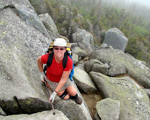
At the Florida Trail conference a couple of weeks ago I met several really nice people who indicated a desire to hike the FL Trail. One of these was a guy named Ian, who knows my friends Charles and Mary well. Since then he heard of a group intending to hike the length of the Ocala National Forest. They will be doing day hikes, but Ian had decided to backpack the same distance, and roughly matching his daily hiking to the same sections as theirs so he will at least bump into them, or hike a short while with them each day.

I could not get the entire week off due to an out of town business trip, but joined in at Juniper Springs, preferring to backpack it with Ian than join the day hikers. We set off northbound from Juniper Springs campground around 6pm for the short hike into Hidden Pond where we intended to spend the night.

The trail passes through the Juniper Wilderness area, where no vehicles, bicycles, etc are allowed, and no motorized equipment is used to maintain the trail. As a result, the trail is a little rougher than most of the FL trail system, with grasses, brush, and several blown down trees, encroaching on the trail. It was a pleasant hike though, especially once the heat disappeared from the sun. We spotted a coral snake on the trail, which I mistook for a scarlett kingsnake, at least until I got home and saw the photos of it. Lucky I didn't try to pick it up! After that, we arrived at Hidden the pond and campsite quite quickly, just as it was getting dark. We quickly got camp set up, etc. I returned to the pond to collect water and wash up for the night, apparently totally oblivious to the alligator who was hanging out with me while I did so, but the next person down to the pond saw only two big red eyes staring out from a few feet out in the water. I guess I need to wear my glasses when I'm bathing!

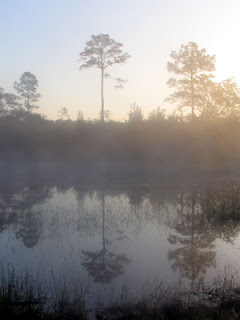
We sat around for several hours talking, and getting eaten alive by mosquitos, then retired for the night. The night was fairly cool, but I'm told byt those that had been out camping the previous night that it was a big improvement. Next morning was cool and misty, but that just made Hidden Pond prettier as the sun rose.

We were fairly slow getting started off in the morning. The fastest of the southbound group of hikers, hiking back to Juniper Springs campground, approached us as we filled up our water for the day. I set off again northbound as he left, and over the next 10 - 15 mins met up with the remainder of the southbound group. They had set off from the Hopkins Prairie campground crossing, and must get up early and hustle first thing in the morning!

The hiking was pleasant while the trail was shaded, and there were many small ponds to rest by. Late morning I scared up something very large in the scrub off to the east of the trail, but could not tell what it was. After the trail left the wilderness area was an area of a mile or so that was apparently very damaged by 2004's hurricanes, and was subsequently clear cut/recovered to remove the blown down trees. It was approaching noon, the sun hot, and only a very light breeze. Fortunately, we arrived at FR86 and the Hopkins Prairie campground sinkhole. We had already decided that if the day turned out to be too hot for hiking, that we would find somewhere shady and pleasant to siesta in the heat of the day. The sinkhole was perfect. Cool water and light shade. We headed down the steps to the sinkhole. I swam a while to cool off, then we ate lunch, and napped for a while. A water snake was hanging around where I had accessed the water, but I didn't get a photo of it. Eventually, the shade moved, and our little piece of paradise became hot and sunny, so we filled up on water again, and moved back into the forest and denser shade for the remainder of the afternoon.

As the shadows moved around during the remainder of the afternoon, we kept moving our gear and our napping selves around to stay in the shade. At one stage, afetr moving to a new shady spot, we noticed a wasp buziing around us, but clearly not interested in us as much as in my pack, and the sandy ground around it. We watched it curiously for a while as it dug around on the ground shoving leaves and tree debris pieces around, obviously looking for something. Shortly afterwards, when we moved again to set up and cook dinner, I found the reason why the wasp had been so interested in my pack. I had put the cak down on the wasp's hole, and it obviously knew it was there, but just could not figure out what had happened to it.
After dinner, hoping that the heat would dissipate quickly in the breeze that had picked, we set off hiking again into Hopkins Prairie. The trail around the Prairie had been closed until very recently due to high water from the hurricanes of the past couple of years. Due to the lack of maintenance the grasses were very overgrown, over head height for the most part, and there were a couple of areas where trail markers had blown away etc. The trail was a little had to follow in places, but as the water was rarely more than 20 - 30 feet from the trees there was usually a good indication of where the trail should go. Any inconvenience on the trail was more than compensated by the beauty of the prairie. The setting sun and the wonderful cooling breeze, with no-one else around made this an idyllic hiking evening.

Around the middle of the prairie I lost the trail blazes and doubled back to the last blaze a couple of times to look for the next one. After several times around and across a clearing, I just could not spot the trail. One possible direction would take me through sludgy sticky looking mud, and another through the edge of the lake, neither of which I was particularly keen to tackle with the light starting to fade. Other options would take me through thick overgrown brush, and just didn't look right. All the possible options would take me out of sight of this last obvious trail marker, and not knowing how far behind me Ian was, the last thing I wanted was for him to reach the same point and magically see the trail, while I was off blaze hunting out of sight. I doubled back a little, hoping to meet up with him and/or see a suitable place to camp for the night. When we did meet up, obviously he did not think the light was fading as fast as I, as we decided to return to where I had lost the trail, and attempt to pick it up again.
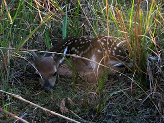
As we skirted round the clearing again to look for the blaze, Ian happened to look down, and at his feet was a tiny fawn resting at the base of some tall grasses. We both pulled out our cameras and spent several minutes up close photographing it. It never moved except to flare it's nostrils a couple of times. We speculated that it's Momma had told it to stay put, and staying put it was. I'm just glad we weren't a couple of gators!
Despite the distraction of the fawn, Ian managed to find the next trail blaze up close to the trees on the opposite side of the clearing (I had been looking too far out towards the water), and we continued on the trail. A short while later, we found a nice breezy, short grass spot among the tall grasses to set up camp for the night. A nearby recently sawed blown down tree provided convenient log seats that were easily rolled the short distance to camp. We had no access to water, but were carrying sufficient to last overnight and for our initail morning needs anyway. It was perfect, and the breeze held most of the mosquitos at bay too! Just before retinring for the night Ian saw the headlights of a car in the area of the clearing where we had seen the fawn. I couldn't see the lights, but did hear the sound of engine and wheels squealing as they driver attempted to release vehicle from the mud he was obviously stuck in! The noise continued for a while, and shortly after we had settled in our respective tents, we heard the sounds of cussing and shouting, as the vehicles occupants returned back on the road they had driven in on, this time on foot! Other than that disturbance, it was a great night for camping, warmer than the previous night, but with the pleasant breeze moderating the temperature. Next morning, the sunrise was as beautiful as the sunset the night before.

We had decided we needed an early start today as the remainder of the group would likely start out very early, and we wanted to hike with them for a while. After a quick breakfast and easy pack up we were on the trail. The trail turned muddy and wet very quickly after we started out. I am in two minds about whether I would have rather have covered the wet section late in the day last night, to give my boots an opportunity to dry out, but the spot we had camped in had been so pleasant that I am glad we stopped. It may also have been not too pleasant to hike through the wet in the dark. Though apparently, last night had not been quite as dark for Ian as it had for me. When I woke this morning and reached for my glasses, I found only my sunglasses. I was sure I had changed out of them when we stopped to photograph the fawn, but obviously had not. That explains why I thought it was getting too dark to hike, and also why I couldn't see the stuck car headlights. Ian had apparently just thought I was trying to be "cool" keeping them on after dark! Thanks hon!

In any case, if we had night hiked this section we might have missed the wild blueberry bushes in the dark and as we discovered this morning, we would have had to hike at least a couple more miles before we would reach another spot suitable for camping.

Not knowing what the water situation would be for the remainder of the day, we stopped at the first fairly easily accessible water and collected, filtered and treated enough for the remainder of the day. While we were stopped the first of the day hikers passed us, stopped for a while to talk, then continued ahead. The next passed us just as I was filled up, repacked and preparing to leave. Shortly after commencing hiking again I came to the wettest area of the trail, with water around mid calf deep. It mainly had a nice packed sandy bottom though, with only a few muddy spots where there were blown down trees, so wasn't too much hassle, just the inconvenience of wet feet.

I passed the second day hiker resting on a blow down before I left the prairie, and leapfrogged with him for a while as I came off the prairie and back into the forest. I also crossed paths with two unknown backpakers. We exchanged only "Hi's", so I'm not sure how long they had been hiking, or how long they were intending to hike, but they sure looked loaded up, yet extremely fresh and clean, so I'm sure they must have just set out. A little while later I arrived at CR314, and met up with the lead day hikers again. As we sat and rested in the shade the remainder of the group trickled in, talked a while and eventually everyone shuttled off.

We arrived at CR314 while the day was still too hot to hike in the sun. However, it wasn't particularly pleasant sitting on the side of the road with trucks racing past either, so we set off northbound into the forest for just a short distance before locating a suitable shady spot to wait until the heat died down a little. At around 6pm it hadn't cooled off much, but we started up for the evening anyway. There was quite a nice breeze blowing up in the tops of the trees, but unfortunately not much was making it down to trail level, except at the frequent dirt road crossings, which we took advantage of for cooling breaks. We were hoping to stop at Store 88, a convenience store and hiker institution where we hoped to stock up on fresh commercial water, as we were uncertain where we would find the next potable water source, and knew we had a long hot dry day ahead tomorrow. At 7pm, with a couple of miles still to cover, we stopped for a dirt road break, and while checking the hiker guide, were confused by the reference to the store as available 11am - 8pm. So we put a little rush on for the next couple of miles, then encountered a blue blaze paited on a tree. The connector trail to Store 88 is marked with blue blazes, but as we had not yet passed the convergence of the East and West Connector trails, we were a little confused. We finally decided that the blue blaze was old, and ignoring it, continued on. Shortly after that we did indeed come to the trail convergence, and very shortly after that, the correct blue blazed side trail.


So we arrived at Store 88, just a little before 8pm, very sweaty, and found that the reference in the book had been to the barbeque store, which we had known was closed anyway. Store 88 is a convenience store attached to a bar, and is open till 2am. So much for rushing!

Store 88 is great. The bartender came out and offered us cold beverages, that were much appreciated. There are picnic tables outside where we could dump and spread out our gear and collapse on to recover from past hour's humid, sticky, rush. We chatted a while with the occupants of another picnic table whose opening comment had been "Are you hiking?". They were very interested and pleasant though. After cooling off a little we decided to eat here instead of worrying about cooking at camp, unfortunately the bar had no food available except re-heated pre frozen sandwiches. We managed with a selection of those, desserts and candy, but there were repercussions from that the next day! When we had eaten dinner and filled up on water and snacks we set out back down the link trail to find somewhere to camp for the night. It was now dark and we had our headlamps on to see. If you've never hiked in the forest at night with a LED headlamp, you probably have no idea how many spiders there are in a forest. But with an LED headlamp, it's like walking into a Warner Brothers cartoon scene. You know, the one where there is a darkened room, and the only thing you see are pairs of white eyes staring back at you. We investigated the closest set of eyes, to find a big wolf spider sittong on the ground. Apparently the compound eyes of a spider glow like neon in reaction to LED light. The rest of the eyes we just tried ignore or avoid! Despite the spiders we decided we would rather camp close by here, than try to get up towards grassy pond. We had full water anyway, so did not need to worry about dry camping, and it was quite late by this time. The trail was under long leaf pines and open understorey here, which would make for a decent campsite, but could make following the trail in the dark a lot more difficult: all those spider eyes would be distracting and make finding the orange blazes harder! So we headed back up the trail and uphill for a while, hoping to get some advantage from the breeze by being up on the hill, set up camp and immediately straight into the tents to avoid the mosquitos.

View more photos in my Picasa album

Sunday, April 9, 2006

Green Swamp West - Lacoochee

The weather is getting hotter and more humid, and prime Florida backpacking time is drawing to an end. There is a missing piece of the Florida Trail through Green Swamp that I was determined to complete before it becomes too hot, so I decided to try to get it done this weekend. Looking at the maps, it appears that there may be a road access in the middle of the missing section, but after last weekends 8+ mile addition to a day hike when the "road" turned out to be locked, I decided to just throw on the backpack and hike through from 471 where Deb and I left off back in early March, to the first place I knew for sure I could get the car into at Lacoochee Clay Sink Road, camping overnight somewhere in the middle. This route would duplicate about 6 miles of last weekend's hike, but I could take more time over the pieces we had hurried, and take the loop hike along the river for the last part.

The day started off cloudy, but warm and humid. The early part of the trail is through open grasslands with sparse shade, so I was grateful for the hazy cloud cover. I startled a deer in the first couple of miles, actually it was a mutual startling, and he bounded away before I had the presence of mind to grab for the camera. Today was the first time while hiking in the Green Swamp and Richloam swamp areas that I have actually encountered other hikers on the trail. My first meeting was with a Boy Scouts of America group out for a five mile hike. We arrived together at a trail junction, and thinking these young men, unencumbered and only day hiking would be travelling at a faster pace than me weighted down with backpack and about 20 lbs of spare water I stopped for a brief drink break and let their group get ahead of me. That was a mistake, as I was soon on the heels of and practically falling over their slower members. Fairly soon I got the opportunity to put on a burst of speed to re-pass them. My next encounter was lone day-hiker who passed while I was taking my lunchbreak in a shady, breezy spot slightly off the trail.

As the day got hotter the sparse shade and high humidity was very draining, and I began to wish I was day hiking. The forest road portions of the trail were on sandy roads, and the lack of rain in this area for the past month or so made for some slow and dusty slogging through the sand.

Early afternoon the trail crossed Ranch Road. This was the road that I thought may have been accesible by car, but had decided not to risk as it was marked exactly the same way as last week's fiasco at Main Line Road. Of course, having not tried it the road was indeed accessible, and there were lots of cars on it! The really bad part was that it was HORRIBLY dusty, and I had to walk along it for about 1/4 of a mile. Every car that went past kicked up a big cloud of choking dust. Several of the more courteous drivers slowed down when they saw me, but it didn't lessen the dust much. I was very thankful when the trail headed back into the woods. The next hour or so was through a beautiful deeply shaded wood of massive mature oaks dripping with spanish moss. It was wonderful cool relief after the sparse shade and the dust. I scared up a very fast black snake that was lazing in the trial, but again the encounter was too brief for the camera.
Mid afternoon I arrived at the Foster Bridge campsite, my home for the night. As soon as I arrived I collapsed on the bench and stretched out for a cool break. The mosquitos immediately homed in. There were enough of them out in broad daylight that I realized I was going to have to get my camp all set up and dinner, etc. completed before the sun went down so I could take refuge in the tent when the bugs really came out! I set up the tent, but it was warm enough and with little enough chance it would rain that I decided to forego the rain fly tonight so I could be out of the bugs, but hopefully get some breeze relief from the humidity too. Next chore was to go down to the river to refill my water bottles and take a cool dip if possible. As I set off for the river I immediately came to another recently burnt area. The wildfires have been quite bad recently due to all the dry weather we have been having. I had walked through so many burnt out patches today I had just not noticed the burnt smell here. As I continued I noticed that the fire here had been very recent. In fact, several areas were still smoldering. My tent was now set up less than 1/10th of a mile downwind on this smoldering burnt area, and it was extermely breezy. Knowing that, I used my hiking pole to rake through smoldering patches until they were no longer smoking. Around the next corner was a fallen burnt out tree, not just smoking, but actually burning with 3 small fires. I used an unburned log I found nearby to beat at the burning areas, and my hiking pole to rake through the dropped embers until the fire was out and nothing was smoking. Eventually I made it down to river to refill my water and wash up, which was even more needed now I was black and sooty! On the return to the campsite I checked all the previously smoking areas and the burnt out tree, but there was now no sign of smoke. I seriously considered repacking my tent and moving elsewhere to camp, but the next marked campsite was a further 6 miles up the trail, and I was not sure of the non site camping restrictions here. Knowing that it was turkey hunting season made me not too keen on remote camping, and seeing as the underbrush in this area was already all burnt out I decided to stay where I was. There are so many burnt out patches in this area anyway, and I hadn't noticed this one smoking until I was almost on top of it, so it is highly likely that anywhere else I chose to camp may also have the same danger anyway.
So I set up my own small fire in the fire ring to cook dinner, and enjoyed the early evening. My assumption had been correct, and as soon as the sun droppd the bugs began to increase, so I took refuge in the tent. The wind has also died down a lot, relieving my fire fears somewhat. Not having the rain fly on increased my visibility outside too, and as it got dark I took another careful look out into the darkness for signs of flames, but there were none. I pottered around in the tent for a while then tried to settle down for the night. It was hot and sticky, and the whining sound of mosquitos was all around the tent.

Of course, a night without the rain fly is a guaranteed drought breaker, and I was awoken by the first shower a little after midnight. I scrambled for the rain fly, jumped out of the tent to attach and stake it out. The most persistent of the mosquitos who had hung around waiting for me to leave the safety of my mesh cocoon were rewarded by my few unprotected minutes outside the tent, but I was fortunate not to let any back in there with me. The rain continued lightly for a while and I must have drifted back to sleep, but was awoken at 3am by an outright downpour accompanied by lightning and thunder. It was hot and humid in the tent, but I was dry and the rain was cooling the tent down rapidly. I got inside the sleeping bag for the first time and eventually managed a couple more hours of broken sleep.
The rain had stopped by the time I got up, but everything was soaked and very muddy and it was extremely humid. The areas around trhe campsite that had looked drab, dirty and dusty yesterday were now somewhat brightened by the overnight soaking. I am fascinated at the way the palmettos recover so quickly after ebing burned and this morning is no different. I had noticed the new green growth yesterday, but this morning it seems liker all the re-growing plants had sprouted the green beginnings of flowerheads. Maybe they had been there before and I just had not noticed. The contrast between burnt black, rust brown damage, and vibrant was beautiful. Anyway, I couldn't resist a few pictures.

I soon reached and crossed Main Line Road, and was now hiking the same area we hiked last weekend. Today however, it is still early, and I have time to enjoy the views and take short breaks on the buffs above the Withlacoochee. On one such break I took off my shoes to dangle my feet in the river and find a tick that has embedded itself in my toe! Nice!
Another break was at a small rapid on the river. There was a Cypress growing against the bank with all its roots and knees exposed and hanging out over the river. I climbed out onto the exposed roots and sat 15 feet above the rapid watching the water flowing underneath me. A much nicer experience than the tick removal.

Despite the rain last night the swamp areas are still very dry, thought there seems to be much more grass than last week. It is above knee high in a lot of places, and I do not remember that from last week, though it seems like it couldn't have grown that high just since last night! There is one little stream crossing on this stretch, and surprisingly the water level actually seems lower this morning.

My final stops for today are along the river loop trail. I'm not sure which river this is, it didn't seem to have enough flow to be the Withlacoochee, but more likely a feeder. The swamp area around the river was a vibrant mas off green grass carpeting around the Cypress trees. The river was serene and clear and seemed to have a good amount of flow. I could hear children's voices and expected to see a canoe appear at any time, but never saw the actual source of the noise, nor anyone for that matter.

View more photos in my Picasa album

Saturday, April 1, 2006

The Fool's Hike


Just judging by the date, we should have known this was going to be one of those days.

First off, it was only supposed to be a short 7 - 8 mile walk, so I'd scoped out a road on the map that crossed the trail so we could shuttle a car to each end for an easy day. Unfortunately, when we turned onto the road in question, it had a locked gate across it! Ooops. Undaunted, we figured we could add the 4 - 5 miles to where I estimated the trail crossed the road, making the hike 12 - 13 miles, and still only take an extra couple of hours. So off we set....

30 minutes or so later when we saw a truck driving the road we're walking, curious, I waved and asked him if it was possible to drive the road instead of walking. Apparently you have to be a hunter with a padlock on the gate. Oh, and by the way, today is the first day of Turkey Hunting Season. Hmmm. how did I miss that one? Still, we decide to continue on, my backpack isn't blaze orange, but it is bright yellow, and we're going to be on the main road for some time anyway, the hunters are likely all off in the woods. So on we walk....

...and walk. You see, I thought we were going to be in the car driving down the road, and figured we'd see the place where the trail crossed the road fairly easily, and park nearby and set off with no problems. So I didn't measure or mark the actual loaction of the trail crossing very accurately on my map. All I vaguely remembered was 4 or 5 miles. After walking 6 miles I began to doubt myself. I hadn't seen any sign of the crossing, and surely we'd gone way too far by now. Perhaps it was the last trail that went off to the north, despite us having not seen the southbound trail, or an orange blaze in sight!

So we doubled back, set off on the trail to the north, and still no blazes in sight. I checked the map, The trail we were on looped northwest for a couple of miles, then back to Main Line Road. Surely it must cross the Florida Trail, and if not, when we get back to Main Line, we can just walk back to the car. We continued. We looked for potential trail crossings and orange blazes. We stopped to eat lunch (Did I mention I forgot my lunch? Thanks Olga for bringing extra). We crossed several sand roads, but nothing that is blazed. We even got into quite an indepth discussion about why some roads and trails are marked on the maps and some are not. We don't see anything orange.

Eventually we arrive back at Main Line Road, and still no sign of the trail! Hearing a train whistle, we stop for a break and take some GPS and map readings. We're now 7 1/2 miles from the car, but only 3 or 4 miles from Lacoochee and highway 301 in the same direction we're travelling. We have hiked 10 miles and not yet seen a sign of the Withlacoochee, or anything even close to the scenic walk we were expecting. We're hot, and more than halfway through our water. There was not a drop of water on the road walk in. The thought of a long break by the river (now only 1/2 mile away) and the chance to replenish water and a 4 mile walk out to the road is very tempting. So Plan B is hatched. We will continue on Main Line Road to US301 and call for a ride back to the cars.

Ever been following a road that you originally thought was a road, and turn a corner to where it crosses the river only to find that someone stole the bridge? No? Believe me, not a great sight when you're now 8 miles from the car, and salvation was a mere 3 or so away! The water level is currently very low. It was quite a challenge to find a spot where I could dangle over the water where it was deep enough to fill water bottles without stirring up the bottom sediment too much. Finally, when I found a suitable spot, the thought of crossing the low water obviously crossed my mind. And I tried. The water was indeed not too deep, and I probably could have got myself across, but the mud close under the shallow water was quite deep, and eventually I was persuaded to return to my companions on the bank. I think if I'd been alone I'd have just repacked the contents of my daypack safely into my garbage bag and swum across.

Decision reached, we begin the 8 mile trudge back to the car. We expect it to be hot, the old railroad grade provides little shade, and it's sandy and dry.

Of course, as we pass the sand road where we had returned to Main Line Road from our loop to the north, there, less than a couple of tenths of a mile, on either side of the road are the wonderfully obvious orange blazes marking the point where the Florida Trail crosses main line road. We had turned back exactly 1/2 mile too soon, but we're still confused how we could have looped around, and across this trail without seeing it!

So, now we are on Plan C, which is actually Plan A. The distance to either car is approximately the same, but the trail has shade, access to the river, etc. The road, while probably providing better footing and a more direct route is the less preferred route.

Once we actually got on the trail the hike was pleasant. We found the point where the trail had crossed our little side loop. We hadn't seen either the trail or the blazes because we were deep in conversation about why some dirt roads were on the maps and GPS and some were not. I guess we should have looked up occasionally! The newly discovered trail was nicely shaded, and very scenic in places. We reached the bluffs above the Withlacoochee River very quickly, but unfortunately we had all reached the "just walk" stage, and didn't get to enjoy it as much as we should have. We did stop for a short break on the river bank and dunked our feet for a while to cool off. I took the camera out only for this initial stop in the high river bluffs, but after the break we all just concentrated on hiking back to the car.

We finally reached the car at Ricloam Fire Tower around 6pm. Our total mileage was 17.4 miles. Hopefully Dick and Olga will still talk to me tomorrow!

View more photos in my Picasa album

Saturday, March 11, 2006

Green Swamp East

This is an impromptu day hike, and I'm joined by frind Deb who is staying a couple of days. She's not usually a hiker, but has agreed to come out for a short walk, so I Looked up the closest trail section of about 10 miles with a parking lot at each end. We shuttled a car to the SR471 parking lot and set out from the Green Swamp East trailhead.

The trail was a mixture of Cypress swamp, oak and pine forest, and crossed the Withlacoochee river several times. There were several sections of forest road walks. The weather was clear with a light breeze, and temps in the 80's. A couple of places were a little too sun exposed in the middle of the day, but for the most part the trail was nicely shaded.

After abot 3 miles we came across some trail signage where a loop trail joined the main trail. It listed the mileage for the thru trail as 10.8 miles. Exactly whatI had planned for the day, except we'd already walked almost 3 - ooops! We discussed just taking the loop trail then doubling back to the car, but Deb decided she was up to the full, now 14 mile hike, so we continued on, but just agreed to slow the pace a little and take a couple of nice long breaks in the shade as the heat increased.

We passed through several areas that had recently burned, but the new green regrowth of grass and Palmetto shows how quickly the forest begins to recover. We ended up taking several short water and snack breaks and two long lay down - shoes off breaks, including an hour long lunch and nap break. We ran short of water in the afternoon, so stopped at a flowing creek to collect and treat water. I actually managed to catch a small fish in my water bottle. I can't even imagine I'd have been able to do that if I'd been trying to catch a fish! We rescued him from the bottle before adding the iodine. I don't think Deb fancied having him swimming around in her water bottle anyway!

Late in the afternoon we crossed the Withlacoochee River once again at a road bridge. The worst of the day's heat had already passed, but the water still looked cool and inviting. We investigated the river bottom and found it was cool soft moss and firm sand, with no slimy mud. We could not resist the opportunity to strip down and enjoy a refreshing soak. We both wished we had been here for our lunchtime nap, but it was a great rest stop any time of day.
At the end of the day, after a wonderful day's hiking, albeit about 4 miles longer than expected, we reached the road, and the southbound register. We flipped open the lid, and found squatters have moved themselves into this nice cosy steel home!

View more photos in my Picasa album

Saturday, March 4, 2006

Hog Island

So my idea of a contiguous NOBO section hike obviously isn’t going to work. Having completed the first 7 or so miles of Big Cypress, the next section is a 3 day backpack trip with no accessible roads to split it up. I could take the time off an do it over a long weekend, but I can’t find anyone to go with me. The Rangers at Big Cypress are strongly advising against going solo. So to continue with my Florida Trail section hike I’ve picked out a couple of day/weekend segments close to home. I’ll just have to wait to finish Big Cypress. This weekend I’m hiking again with Mindy, who came on the Loop Road hike.

We started out the day at Hog Island campground, where we secured a camp site for the night, and left one vehicle, then drove to At River Junction where we left the second vehicle. After a brief false start we realized we had not actually seen an orange blaze since we left the car, and we doubled back and took the correct left turn (the one on the left!), actually headed down the correct sand road to River Junction and the start of the Croom Trail.

From the trailhead the trail skirts several small Cypress swamps. We really enjoyed the clear still water, with the sunshine flooding through the new spring green of the trees. Eventually the trail wound its way to the Withlacoochee River, back to the swamps, and then oak forest.

We saw plenty of wildlife throughout the day, from deer in the campgrounds, to birds, butterflies, a very fast black snake, and the little turtle. The butterfly would only allow me within a couple of feet, then would fly about 20 feet down the trail, let me within a couple of feet and fly 20 feet further. This went on for long enough that we thought it was hiking the trail with us! Eventually he flew off into the forest without us.

The last 1/4 mile of or so of the trail was through a pine forest, and we were home at our campsite for the night, complete with a campfire and steak dinner.

View more photos in my Picasa album

Saturday, February 11, 2006

Southern Arizona Trip

First stop for the trip was at Watson Hot Well just outside Thatcher, AZ. The well is on BLM land with free camping. The tub was empty when I arrived late afternoon, but soon filled with nice warm water. It was a cloudy day, and I had travelled through some cold drizzly rain earlier in the day, but the sky cleared off around sunset.

Chiricahua National Monument
Chiricahua is an area of volcanic rock that was uplifted causing vertical colmnar fragmentation. Erosion of the softer layers has caused unique reshaping of the columns. Some of the columns have eroded to the extent that big rock is left balancing on the top of the column, and some of the erosion gives the impression of facial or animal features. The raised rock area is known as a "Sky Island". There is no water around to make it a true island, but is sits out as a standalone mountain in the sea of surrounding desert. At a couple of places on the Heart of Rocks trail the surrounding desert was a vivid yellow and red flat contrast to the rocks and blue sky.

At the end of the day's hiking I wandered around Masai Point in the very windy cold for the sunset. It was so cold that the batteries in my camera registered as dead, a new set lasted only a couple of photos before also showing as empty. I was judicious with the camera, keeping it warm inside my jacket between photos and managed to squeeze off a few last shots.

Saguaro National Park is a Sonoran Desert landscape dominated by the uniquely recognizable Saguaro cactus.

Picacho
Final stop for this trip is a Hohokam petroglyph site not far from Picacho Peak State Park. The Petroglyphs are scattered over a large heap of boulders which involved scrambling around and over the rocks to get to the pictures. It was a very pleasant afternoon, and after climbing around a while I just found a comfortable rock to plant myself on and enjoy the late afternoon sunshine.

After enjoying the sunshine for a while I packed up the car and drove back to Phoenix, with one last stop for a picture of the moonrise over the Saguaros.

View photos in my Picasa album

Sunday, January 29, 2006

Starting at the Beginning

I started off with this idea that I wanted to hike the entire trail, albeit in sections, contiguously from South to North. However, the trail starts with one of the most remote sections, Big Cypress National Preserve. I had read in the Florida Trail literature, and other trip journals that the lower swamp sections are strenuous, and should not be attempted alone. The water level in the swamp is currently quite high from Hurricane Wilma’s passage over south Florida late last fall. As luck would have it, I stumbled across a group that annually hikes the Loop Rd to Oasis Visitor Center segment. I contacted them and they agreed to let me join them. At the last minute, Mindi, a recent acquaintance from an online Women's hiking group decided to join me too. We drove down to the meeting point at the Oasis Visitor center in the middle of the night. The highlight of our drive was on SR 29, shortly after exiting Interstate 75. Passing through the Florida Panther refuge area, we saw a panther on the side of the highway. An exciting first for both of us. It would have been nice if I had had the presence of mind to stop or double back to attempt a photo!

We arrived at Oasis visitor center at around 5:30am and settled down for a power nap. I managed an hour or so of sleep before birdsong and the sounds of the occupant of a nearby vehicle woke me. We boiled some water for coffee and oatmeal breakfast, then stopped by the gator pond to enjoy our morning coffee before the group assembled at 8:30ish.

At 9am we stopped by the visitor center, arranged for the permit, checked with the Ranger for current trail conditions, and watched the 15 minute video about the ecology of the Preserve. The Ranger advised that the trail was rough, and mostly under mud and likely knee high water. He warned about the large numbers of Cottonmouth snakes, but thought we should get through OK. We shuttled in one van about 13 miles by road to the trailhead where we were joined by the remainder of the group. We saw 3 gators and a deer on the lime road, the only wildlife we saw all day. In all there were eleven in the hiking group, Mindi and myself being the only women.

It was around 10:30 when we set off on the trail. The weather was great for hiking, warm enough to be comfortable with a minimum of clothes, but not hot, and with a gentle breeze. The cypress trees have no foliage at this time of year, and the bromeliads and other plants have just started to flower. The predominant colors are silver grey, with a lightly overcast blue sky. The trail for most of its length is potholed limestone base covered by varying depths of dark, slippery mud and puddles.

Within 20 feet the trail is muddy, and wet, and water was already over the tops of my shoes giving me wet feet. A previous swamp backpack trip 2 weeks ago had left me with large blisters on my left heel and toe. Neither were bothering me now, but I was a little concerned that with the immediate wet that I may be in for a recurrence of either, both, or more.

The three first mile of the hike is through a cypress grove and grassy prairie. There is little shade, and the sky cleared somewhat in the warmest part of the day, but was still pleasant. We saw bobcat and raccoon tracks, a variety of birds, signs of deer remains (presumably some cat's feast), and cypress trees that were obviously "cat scratch" posts, but no other wildlife. We intended to stop for lunch at Frog Hammock Camp (a "hammock" is a slightly elevated and therefore often drier island in the swamp) but it was already occupied when we arrived, so we continued on.

The trail at this 3 - 4 mile section becomes much more swamplike. Elevation changes of only a few feet make swampy pools of slowly moving water among slightly raised areas of brush, vines, ferns, and other undergrowth. There is much more green and brown. A compost like base to the trail means less mud and limestone directly underfoot, but to get to these raised areas the trail passes through the swamp pools. The water here covers the same several inches of mud over limestone, and was mainly around knee high. The water was clear for those lucky enough to traverse first. For those in the rear the slowly swirling mud obscured the potholes, cypress knees, fallen logs, roots, etc. A hiking pole is definitely an advantage here for probing ahead to gauge footing and depth, and for stability when a pothole, root, knee, stump, other unseen hazard, or just plain old mud causes imbalance. On the raised hammocks the water is no longer an issue, but the dense undergrowth means bushwhacking though vines, palmetto scrub, under and over fallen trees, limbs, etc.

This mile or so of trail has been heavily affected by Hurricane Wilma last fall. Many of the trees that have the trail marking orange blazes have fallen. Many more trees are down across the trail, and the undergrowth is thick and thorn covered. We frequently could not see the next orange marker and could not discern which direction the trail continued. At these places several of the front hikers would fan out looking for blazed trees, while the remainder waited back at the last known blaze. When someone discovered the next marker we would all attempt to follow their course, and seek out the next blaze.

It was only a fairly short stretch where this was a concern, but bushwacking hiking like this is tedious and time consuming. We had not yet even had lunch, and for a short period there was some discussion of maybe retracing our steps to return back the way we had come. Eventually though, we stumbled our way from blaze to blaze and somewhere around mile 4 got back to a fairly straight, though submerged trail that could be easily followed. Here, in a slightly raised area with not too much brush we stopped for lunch. There was no real dry ground. Some settled on a log or stump, but most (including me) just stood to eat.

The trail here turned to a channel of knee high water over the mud, limestone potholes, cypress roots and knees. There was little underbrush allowing a faster, though splashier pace. As we set off, someone noticed that we had shared our lunch spot with a snake. I was already several yards down the trail, and did not go back to see it, but those that did said it was a Cottonmouth. It was less than 2 feet from where one of the party had just rested for 20 minutes eating lunch, and not one of us had seen it!

The submerged trail continued as this slosh through muddy water. The mud underfoot was ever present, with the potholes, cypress knees, logs, etc., providing frequent obstacles. One step the water may be only 6 inches deep, the next maybe up to the knees. After about 1/2 mile the land elevated slightly and the terrain turned back to the cypress prairie that we had encountered for the first several miles. Most of the deep water disappeared, but the mud here was deeper than the start of the hike. Maybe it was just perception as now my legs were getting tired, and my shoes were now filled with and encased in several pounds of mud, but the mud seemed slippier too. The deepest, slippiest sections caused a vacuum to be created within my shoes at each step. This meant curling my toes to release the inner shoe vacuum. My feet were already kind of busy trying to move forward, stay gripped on the trail, lift pounds of slimy mud, avoid potholes, and attempt to keep my legs and body in a vertical position. Now I was asking them to curl up to de-suction too. They weren't very happy with me! Once again I was grateful for the hiking pole, which prevented me falling several times.

During this muddy mile, while concentrating almost exclusively on where feet were being placed we came across two more Cottonmouths lying right next to the trail. Seeing three in such a short distance made me wonder how many we hadn't seen!

The final mile or so of trail was less prairie and more Cypress trees. The trail was still as muddy, and the trudging through it slow. Finally, at the 7 mile mark the road and Oasis visitor center are visible through the leafless cypress trees. Just another 1/4 mile, and a couple of large mud holes (which were mercifully mainly dry) we were back on dry pavement at Oasis. The visitor center has an outdoor faucet, which was put to use de-mudding and shoe washing, and bathrooms, where I washed and combed up and tried to look human again. As hard as the hike had seemed on my feet they were totally blister free, and actually didn't feel at all bad once happy again in clean dry socks. I have decided to attribute my problems two weeks ago to wearing a different brand of sock, which must have compressed too much when wet and allowed my left foot to slide within the shoe. I'll stick to my wool socks and synthetic liner in future. We headed for home, stopping for a "greasy McBurger" on the way home. We had definitely worked off any additional calories and fat it might cause.

View more photos in my Picasa album