
Just judging by the date, we should have known this was going to be one of those days.
First off, it was only supposed to be a short 7 - 8 mile walk, so I'd scoped out a road on the map that crossed the trail so we could shuttle a car to each end for an easy day. Unfortunately, when we turned onto the road in question, it had a locked gate across it! Ooops. Undaunted, we figured we could add the 4 - 5 miles to where I estimated the trail crossed the road, making the hike 12 - 13 miles, and still only take an extra couple of hours. So off we set....
30 minutes or so later when we saw a truck driving the road we're walking, curious, I waved and asked him if it was possible to drive the road instead of walking. Apparently you have to be a hunter with a padlock on the gate. Oh, and by the way, today is the first day of Turkey Hunting Season. Hmmm. how did I miss that one? Still, we decide to continue on, my backpack isn't blaze orange, but it is bright yellow, and we're going to be on the main road for some time anyway, the hunters are likely all off in the woods. So on we walk....
...and walk. You see, I thought we were going to be in the car driving down the road, and figured we'd see the place where the trail crossed the road fairly easily, and park nearby and set off with no problems. So I didn't measure or mark the actual loaction of the trail crossing very accurately on my map. All I vaguely remembered was 4 or 5 miles. After walking 6 miles I began to doubt myself. I hadn't seen any sign of the crossing, and surely we'd gone way too far by now. Perhaps it was the last trail that went off to the north, despite us having not seen the southbound trail, or an orange blaze in sight!
So we doubled back, set off on the trail to the north, and still no blazes in sight. I checked the map, The trail we were on looped northwest for a couple of miles, then back to Main Line Road. Surely it must cross the Florida Trail, and if not, when we get back to Main Line, we can just walk back to the car. We continued. We looked for potential trail crossings and orange blazes. We stopped to eat lunch (Did I mention I forgot my lunch? Thanks Olga for bringing extra). We crossed several sand roads, but nothing that is blazed. We even got into quite an indepth discussion about why some roads and trails are marked on the maps and some are not. We don't see anything orange.
Eventually we arrive back at Main Line Road, and still no sign of the trail! Hearing a train whistle, we stop for a break and take some GPS and map readings. We're now 7 1/2 miles from the car, but only 3 or 4 miles from Lacoochee and highway 301 in the same direction we're travelling. We have hiked 10 miles and not yet seen a sign of the Withlacoochee, or anything even close to the scenic walk we were expecting. We're hot, and more than halfway through our water. There was not a drop of water on the road walk in. The thought of a long break by the river (now only 1/2 mile away) and the chance to replenish water and a 4 mile walk out to the road is very tempting. So Plan B is hatched. We will continue on Main Line Road to US301 and call for a ride back to the cars.
Ever been following a road that you originally thought was a road, and turn a corner to where it crosses the river only to find that someone stole the bridge? No? Believe me, not a great sight when you're now 8 miles from the car, and salvation was a mere 3 or so away! The water level is currently very low. It was quite a challenge to find a spot where I could dangle over the water where it was deep enough to fill water bottles without stirring up the bottom sediment too much. Finally, when I found a suitable spot, the thought of crossing the low water obviously crossed my mind. And I tried. The water was indeed not too deep, and I probably could have got myself across, but the mud close under the shallow water was quite deep, and eventually I was persuaded to return to my companions on the bank. I think if I'd been alone I'd have just repacked the contents of my daypack safely into my garbage bag and swum across.
Decision reached, we begin the 8 mile trudge back to the car. We expect it to be hot, the old railroad grade provides little shade, and it's sandy and dry.
Of course, as we pass the sand road where we had returned to Main Line Road from our loop to the north, there, less than a couple of tenths of a mile, on either side of the road are the wonderfully obvious orange blazes marking the point where the Florida Trail crosses main line road. We had turned back exactly 1/2 mile too soon, but we're still confused how we could have looped around, and across this trail without seeing it!
So, now we are on Plan C, which is actually Plan A. The distance to either car is approximately the same, but the trail has shade, access to the river, etc. The road, while probably providing better footing and a more direct route is the less preferred route.
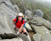
 Once we actually got on the trail the hike was pleasant. We found the point where the trail had crossed our little side loop. We hadn't seen either the trail or the blazes because we were deep in conversation about why some dirt roads were on the maps and GPS and some were not. I guess we should have looked up occasionally! The newly discovered trail was nicely shaded, and very scenic in places. We reached the bluffs above the Withlacoochee River very quickly, but unfortunately we had all reached the "just walk" stage, and didn't get to enjoy it as much as we should have. We did stop for a short break on the river bank and dunked our feet for a while to cool off. I took the camera out only for this initial stop in the high river bluffs, but after the break we all just concentrated on hiking back to the car.
We finally reached the car at Ricloam Fire Tower around 6pm. Our total mileage was 17.4 miles. Hopefully Dick and Olga will still talk to me tomorrow!
View more photos in my Picasa album
No comments:
Post a Comment